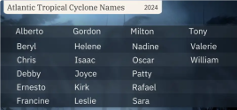
2024 Hurricane and Tropical Weather

DNA Solves
DNA Solves
DNA Solves

PayrollNerd

Well-Known Member
Joined
Feb 3, 2018
Messages
18,558
Reaction score
109,349

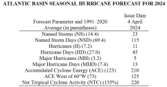
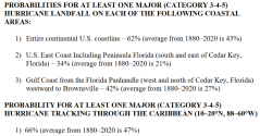
EXTENDED RANGE FORECAST OF ATLANTIC SEASONAL HURRICANE
ACTIVITY AND LANDFALL STRIKE PROBABILITY FOR 2024

We anticipate that the 2024 Atlantic basin hurricane season will be extremely active. Current El Niño conditions are likely to transition to La Niña conditions this summer/fall, leading to hurricane-favorable wind shear conditions. Sea surface temperatures in the eastern and central Atlantic are currently at record warm levels and are anticipated to remain well above average for the upcoming hurricane season. A warmer-than-normal tropical Atlantic provides a more conducive dynamic and thermodynamic environment for hurricane formation and intensification. This forecast is of above-normal confidence for an early April outlook. We anticipate a well above-average probability for major hurricanes making landfall along the continental United States coastline and in the Caribbean. As with all hurricane seasons, coastal residents are reminded that it only takes one hurricane making landfall to make it an active season. Thorough preparations should be made every season, regardless of predicted activity.
1714040741047.png

1714040790932.png
 

Current El Niño conditions are likely to transition to La Niña conditions this summer/fall, leading to hurricane-favorable wind shear conditions. Sea surface temperatures in the eastern and central Atlantic are currently at record warm levels and are anticipated to remain well above average for the upcoming hurricane season. A warmer-than-normal tropical Atlantic provides a more conducive dynamic and thermodynamic environment for hurricane formation and intensification. This forecast is of above-normal confidence for an early April outlook. We anticipate a well above-average probability for major hurricanes making landfall along the continental United States coastline and in the Caribbean. As with all hurricane seasons, coastal residents are reminded that it only takes one hurricane making landfall to make it an active season. Thorough preparations should be made every season, regardless of predicted activity.
 
Published 3/4/24


"We've got possibly extremely warm sea surface temperatures, especially in the main (hurricane) development region and the prospect of La Niña being in place," said Florida State climatologist David Zierden. "That's not good news for hurricane season."
 
Last edited:

An area of low pressure located approximately 900 miles northwest of the Cabo Verde Islands has been generating a limited yet consistent region of showers and thunderstorms east of its core since Wednesday.
 

USA TODAY

Unprecedented ocean temperatures make this hurricane season especially dangerous​

Dinah Voyles Pulver, USA TODAY
Sun, June 2, 2024, 5:06 AM EDT·6 min read
495

The world's oceans have consistently been breaking daily heat records since early 2023, a yearlong fever that has climate scientists, coral reef experts and even hurricane forecasters concerned and dismayed.

In the main region of the Atlantic Ocean where hurricanes develop, water temperatures are "absolutely stunning," said Brian McNoldy, a senior research associate studying hurricanes at the University of Miami's Rosenstiel School.

[More at link including the map below]

Water temperature anomalies in the Atlantic Ocean's main hurricane development region are now the warmest on record going into hurricane season, said Michael Lowry, a hurricane specialist at WPLG Local 10 in Miami, in a column for Yale Climate Connections.

Water temperature anomalies in the Atlantic Ocean's main hurricane development region are now the warmest on record going into hurricane season, said Michael Lowry, a hurricane specialist at WPLG Local 10 in Miami, in a column for Yale Climate Connections.
 
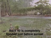
Yup, lots of rain in a short period of time. Half of my backyard flooded and I'm not in a flood zone.


A moisture-laden storm currently pummeling Florida has dumped more rain on Sarasota in only 24 hours than the city received over a five-day period during Hurricane Ian in 2022.

A plume of moisture from the Caribbean is bringing excessive rain to the region. Meteorologists previously expected the heaviest rains to occur from Wednesday to Friday, but downpours have already brought a deluge to southwestern Florida, including in Fort Myers and Sarasota. So much rain fell in only one hour in Sarasota that it broke a 52-year-old record by nearly an inch on Tuesday evening.
 

Attachments

  • IMG_4991.jpeg
    IMG_4991.jpeg
    128.4 KB · Views: 7
  • IMG_4992.jpeg
    IMG_4992.jpeg
    128.5 KB · Views: 7
  • IMG_4994.jpeg
    IMG_4994.jpeg
    145.1 KB · Views: 7

The National Weather Service said that one of its stations in Siesta Key, less than 7 miles from Sarasota, reported nearly a foot of rain with many areas getting over 5 inches within the past 24 hours. Sarasota and several other nearby areas saw even higher rainfall amounts, the agency said, with coastal Sarasota seeing between 6 and 10 inches of rain on Tuesday.
 

Staff online

Members online

Online statistics

Members online
178
Guests online
1,598
Total visitors
1,776

Forum statistics

Threads
599,882
Messages
18,100,723
Members
230,944
Latest member
Picle
Back
Top