The bottom line is that if there was CCTV of Mollie at some point during her run, police would be able to say what she was wearing. They can't. Also, if there was footage, it's very likely that it would be posted if only to give the public a better idea of what Mollie looked like that day.
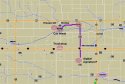
What we know is that Mollie went jogging at 7:30, and she was seen running East on W. Pershing Drive. We don't know where she was abducted, but presumably it was a short time after that sighting. Given the dots on the police map, a points of interest are W. Pershing Dr., and also directly East of Brooklyn. I think we can all agree that as soon as Mollie was abducted, she was taken out of Brooklyn on a road with less traffic.
The dots on the map relate to possible locations of the abductor, locations of Mollie, and possible locations where Mollie and the abductor were together. I think we can assume that the two dots on the right side of the map correspond to locations where Mollie and the abductor were together. People who live in Brooklyn need to think carefully about those five locations on the map.
How can those who don't live in Brooklyn figure out where the abductor took Mollie after the digital signature stopped near Guernsey? What do we know that helps us figure out his next move?