


kanzz
kanzz=kansas
- Joined
- Apr 22, 2008
- Messages
- 1,272
- Reaction score
- 66
Here's a different view of Platte Landing Park.
Blue star = boat ramp
Red star = vehicle recover location
White arrow = direction of river flow

Good map, thank you.
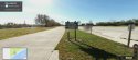
There isn't much available on Street View, but it's worth a peek.
Here's a possible scenario:
She might have been speeding, followed this road and gone around the curve to the left, which would have taken her (inadvertently) to the boat ramp. But there is NO WARNING posted that I can see.
https://www.google.com/maps/place/K...aa51a2!8m2!3d39.0997265!4d-94.5785667!6m1!1e1
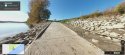
and then when she got to the boat ramp, she saw her mistake, applied the brakes, flipped her car, and went into the river:
https://www.google.com/maps/place/K...8525e66aaa51a2!8m2!3d39.0997265!4d-94.5785667
As the car rolled or flipped before it entered the water and the glass broke, the phone could have been thrown out. This would explain why it pinged that night. Maybe LE found her phone at the site.
")