


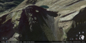
Pic de la Glère is the craggy peak in the left side of this image. Port de la Glère is just above the scree field to the right. The point of view here is southwest into Spain:I think I need to have a look on Google maps etc, I can't really visualise that Pic in relation to the planned circular route (or indeed the possible but less likely route across the ridge).
Google Earth
Port de la Glère was at the end of the loop through France according to DC's dossier, and the Pic just east and above it on the border ridge.
Attachments
Last edited:

 . She said "Tomorrow heading for Port de le Glere or something spelt like that" and she did spell it slightly wrong, though it was very clear what she meant. English speakers can struggle with le/la and all the diacritics.