I read this before you posted it, after you posted it and again when you posted this response and cannot see that anywhere in the piece, can you perhaps quote the piece you mean incase I am somehow missing that? It could be a formatting issue which I sometimes have issues with.The article suggests that SS was killed by a traveller living along the street where she was located.

You are using an out of date browser. It may not display this or other websites correctly.
You should upgrade or use an alternative browser.
You should upgrade or use an alternative browser.
UK UK- Sally Shepherd, 24, Worked @ Young Vic Theatre, Dragged through wire fence, Raped & beaten by ‘Beast of Peckham’, 1 Dec.'79 *Rootless Hair*
- Thread starter dotr
- Start date


My article refers to travelers living in the area. Kevin was a name mentioned on Facebook, however I can't link it here.I read this before you posted it, after you posted it and again when you posted this response and cannot see that anywhere in the piece, can you perhaps quote the piece you mean incase I am somehow missing that? It could be a formatting issue which I sometimes have issues with.
Because the rules of this forum are that things have to be fact based and backed up with an approved link, like the press or police, or somewhere who also have to back to facts with a link like Wikipedia, I think fb is only allowed if it's an open page ran by the police or with information supplied by the police or ran by victim's families...this is the gist of what I am getting...still learning as I go along. Also you can't just say so and so did it when it's unproven, any supposition has to be said in such a way as it's clear it's not a fact but in my opinion, or your opinion in this case. I try to infer when things are in my opinion in different ways as the group acronyms which I find hard to remember and unnatural when I do.My article refers to travelers living in the area. Kevin was a name mentioned on Facebook, however I can't link it here.
It is easy to get cases mixed up, refreshing Sally's thread with a link, not for the '' Yorkshire Ripper" part, just the known details. rbbm,

 southwarknews.co.uk
''Sally was 24-years-old in 1979 when she was working as a restaurant manager. In the early hours of the first day in December that year she stepped off a night bus at Clayton Road and began to walk across Peckham High Street, and Staffordshire Street to her flat when a man stepped out from the shadows and struck her on the back of her head with a blunt instrument.
southwarknews.co.uk
''Sally was 24-years-old in 1979 when she was working as a restaurant manager. In the early hours of the first day in December that year she stepped off a night bus at Clayton Road and began to walk across Peckham High Street, and Staffordshire Street to her flat when a man stepped out from the shadows and struck her on the back of her head with a blunt instrument.
After visiting friends in Essex that night, Sally was rushing home to prepare to move house the next day, away from Peckham, where she had told friends previously she was scared of being attacked. She bought an Indian takeaway and rushed for the last bus at New Cross just before 1am. When the bus arrived at its final stop in Clayton Road, Sally asked if she could stay on till the depot as it was closer to her home in Friary Road. The conductress told her that was against the rules so she got off the bus and walked towards her bloody fate. Dressed in a brown jacket, blue jeans, and tan knee length boots, Sally was just 600 yards from home when she was dragged into a builder's yard a stone's throw from Peckham police station. Sally was clubbed unconscious, stripped, stamped on so hard that her spine was severely damaged, and dragged through a ripped open wire fence.
This was a brutal attack which left blood spatters several feet from the place where two workmen found her body. The inspector leading the case said it must have been the work of a maniac and that he had never seen such a brutal attack in his 24 years as an officer.''
''The incident defies all the logic of the usual sex attack, DS John Hobden said at the time. Sally's savaged body was dumped at the back of Peckham police station and the pathologist, Iain West, gave the cause of death as shock due to multiple injuries. The killer, dubbed ?the beast of Peckham?, was never caught, but there were suspects. One witness saw a man weeping and banging his head against a wall where Sally died, and in September, 1991, a 55-year-old man was arrested and questioned about the killing. He was released on bail, but no charge was ever brought.''
Did the Yorkshire Ripper strike in Peckham? - Southwark News
Ex-police officer believes Sally Shepherd's killer was one of this country?s most prolific serial killers
After visiting friends in Essex that night, Sally was rushing home to prepare to move house the next day, away from Peckham, where she had told friends previously she was scared of being attacked. She bought an Indian takeaway and rushed for the last bus at New Cross just before 1am. When the bus arrived at its final stop in Clayton Road, Sally asked if she could stay on till the depot as it was closer to her home in Friary Road. The conductress told her that was against the rules so she got off the bus and walked towards her bloody fate. Dressed in a brown jacket, blue jeans, and tan knee length boots, Sally was just 600 yards from home when she was dragged into a builder's yard a stone's throw from Peckham police station. Sally was clubbed unconscious, stripped, stamped on so hard that her spine was severely damaged, and dragged through a ripped open wire fence.
This was a brutal attack which left blood spatters several feet from the place where two workmen found her body. The inspector leading the case said it must have been the work of a maniac and that he had never seen such a brutal attack in his 24 years as an officer.''
''The incident defies all the logic of the usual sex attack, DS John Hobden said at the time. Sally's savaged body was dumped at the back of Peckham police station and the pathologist, Iain West, gave the cause of death as shock due to multiple injuries. The killer, dubbed ?the beast of Peckham?, was never caught, but there were suspects. One witness saw a man weeping and banging his head against a wall where Sally died, and in September, 1991, a 55-year-old man was arrested and questioned about the killing. He was released on bail, but no charge was ever brought.''
Do you have proof that the police suspected this person? Because this is all supposition / hearsay.You can find sentencing remarks for R v Kevin Mulholland where he murdered a traveller, however the police cannot prove the traveller's guilt.
Also travellers often get blamed when there's a crime due to prejudice against them.
Btw I can't necessarily find proof of R v Kevin Mulholland as you're really supposed to find the proof since you raised this supposition. I have no clue where you're bringing this from.
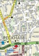
Setting the scene at the time a little. As obviously the area has changed and I can't find a map of that time.
 www.layersoflondon.org
 en.m.wikipedia.org
In the witness statement of the bus conducter/conductress, Sally had to get off the bus on the last stop Clayton Road, (unknown bus stop as bus stops can move so it's difficult to know from that long ago, however it's the opposite side of Peckham High St from Staffordshire Rd), one press story says she got off at a Top Rank Bingo, which I researched, it is no longer there, before becoming a bingo hall it was a cinema, a large building 169 Peckham High Street, straddling the openings of Marmont Road and Staffordshire St, with the main door opening on the corner of Marmont St, there's a large blue building there now. Sally requested to be let off at the bus Depot which was closer to home. I searched for the depot on google maps previously, when looking for where she died, got off the bus, lived etc and couldn't find it. Just a bus station a little further down Peckham High St, basically looks like a car park for buses. Made little sense to me if she meant there as it's no nearer her home.
Well I now find the bus Depot referred to is no more, it was demolished in the 1990s and part of the space it took up is now where Morrisons supermarket is in the Aylesham Centre, Layers of London refers to as Safeway, their supermarkets are defunct since around 2005 and their stores as far as I know mostly became Morrisons.
Again the location is not closer to Sally's home, maybe the reason Sally wanted to get out there was she not only avoided Staffordshire St, but also disliked that stretch of the High St too, despite there being a police station. Sometimes police stations were purposefully built in troublesome areas, I don't know if that's relevant here.
Anyway, the quickest way for Sally to get home was either Staffordshire St or the next road along Marmont Rd, Sally's street joined onto Staffordshire St, so she couldn't stray too far from it. I've not found her actual address on Friary Road, I only know it was above a vacant shop.
It would help to see how the area was at the time, the above layer, 1940s - 1970s covers such a long period and generally settles on some time in the 1950s, 1970s maps are almost impossible to find online. However you do get to see how much it's changed between then and now, that there were empty areas then, partly from bombing in the war, often due to austerity, those areas were left undeveloped for decades after the war.
Photo of how the Top Rank Bingo looked, angle is from Marmont Rd, Peckham High St side,
Another photo from the same angle 1989. The opening to Staffordshire St would be at the far end of the building to the right.
Also some press stories stated that Sally got her curry and boarded her bus in New Cross, that would suggest she caught two buses after leaving the central line at Tottenham Court Road.
Peckham Bus Garage
Bus Garage. Tillings occupied the premises in 1876, which was then called Bull Yard. In 1905 it was adapted by them as a garage for 35 buses and 4 petrol tanks - be the first example of bulk storage for a bus company. From 1911 it was Tillings’ engineering headquarters and bus bodies were built...
Safeway (UK) - Wikipedia
In the witness statement of the bus conducter/conductress, Sally had to get off the bus on the last stop Clayton Road, (unknown bus stop as bus stops can move so it's difficult to know from that long ago, however it's the opposite side of Peckham High St from Staffordshire Rd), one press story says she got off at a Top Rank Bingo, which I researched, it is no longer there, before becoming a bingo hall it was a cinema, a large building 169 Peckham High Street, straddling the openings of Marmont Road and Staffordshire St, with the main door opening on the corner of Marmont St, there's a large blue building there now. Sally requested to be let off at the bus Depot which was closer to home. I searched for the depot on google maps previously, when looking for where she died, got off the bus, lived etc and couldn't find it. Just a bus station a little further down Peckham High St, basically looks like a car park for buses. Made little sense to me if she meant there as it's no nearer her home.
Well I now find the bus Depot referred to is no more, it was demolished in the 1990s and part of the space it took up is now where Morrisons supermarket is in the Aylesham Centre, Layers of London refers to as Safeway, their supermarkets are defunct since around 2005 and their stores as far as I know mostly became Morrisons.
Again the location is not closer to Sally's home, maybe the reason Sally wanted to get out there was she not only avoided Staffordshire St, but also disliked that stretch of the High St too, despite there being a police station. Sometimes police stations were purposefully built in troublesome areas, I don't know if that's relevant here.
Anyway, the quickest way for Sally to get home was either Staffordshire St or the next road along Marmont Rd, Sally's street joined onto Staffordshire St, so she couldn't stray too far from it. I've not found her actual address on Friary Road, I only know it was above a vacant shop.
It would help to see how the area was at the time, the above layer, 1940s - 1970s covers such a long period and generally settles on some time in the 1950s, 1970s maps are almost impossible to find online. However you do get to see how much it's changed between then and now, that there were empty areas then, partly from bombing in the war, often due to austerity, those areas were left undeveloped for decades after the war.
Photo of how the Top Rank Bingo looked, angle is from Marmont Rd, Peckham High St side,
Another photo from the same angle 1989. The opening to Staffordshire St would be at the far end of the building to the right.
Also some press stories stated that Sally got her curry and boarded her bus in New Cross, that would suggest she caught two buses after leaving the central line at Tottenham Court Road.
Last edited:
Maybe there's a link limit, but one of my links seems to have vanished
The 1989 photo referred to towards the end of my last post
 database.theatrestrust.org.uk
The 1989 photo referred to towards the end of my last post
Site previously occupied by the Hippodrome, Peckham, 1989 | Theatres Trust
Maybe there's a link limit, but one of my links seems to have vanished
The 1989 photo referred to towards the end of my last post
Site previously occupied by the Hippodrome, Peckham, 1989 | Theatres Trust
Site previously occupied by the Hippodrome, Peckham, 1989 | Theatres Trust

''Site previously occupied by the Hippodrome, Peckham, 1989
DEPICTED THEATRE
Crown Theatre''


,
I found this map on pinterest, if you read up in locations, the street names are there, but I added the rough location of the bus Depot/ garage (now demolished) that Sally asked to be dropped off at rather than the Clayton Rd last stop, which the bus conductor stated Sally had said was closer to her home. As you can see, Friary Rd where she lived is further along Sutherland Rd and this location is no closer. Maybe she felt it a safer area to get off the bus and avoid going down or near Staffordshire St taking a safer route via Marmont Rd or even further out of her way, Peckham Hill St then doubling back to Friary Rd via Goldsmith Rd or Commercial Way. Generally if you're worried about your safety you'll give iffy areas a wide birth and try to stick to well lit places with people and houses nearby who can come to your aid. So anyway, had they allowed Sally to stay on then she could have probably got home safe. Buses still do this not allowing people to stay on at last stops, even if they are going to then turn around or head to a depot and keep vulnerable people safe.
I found this map on pinterest, if you read up in locations, the street names are there, but I added the rough location of the bus Depot/ garage (now demolished) that Sally asked to be dropped off at rather than the Clayton Rd last stop, which the bus conductor stated Sally had said was closer to her home. As you can see, Friary Rd where she lived is further along Sutherland Rd and this location is no closer. Maybe she felt it a safer area to get off the bus and avoid going down or near Staffordshire St taking a safer route via Marmont Rd or even further out of her way, Peckham Hill St then doubling back to Friary Rd via Goldsmith Rd or Commercial Way. Generally if you're worried about your safety you'll give iffy areas a wide birth and try to stick to well lit places with people and houses nearby who can come to your aid. So anyway, had they allowed Sally to stay on then she could have probably got home safe. Buses still do this not allowing people to stay on at last stops, even if they are going to then turn around or head to a depot and keep vulnerable people safe.
Attachments
From the description of how close to home Sally was, plus the fact she lived over a disused shop, I have narrowed down where she lived to the section of Friary Rd between the junctions of Fenham Rd and Holbeck Row.
There's a row of Victorian shops now converted into residential and two still existing shops in the tall building in the opposite side, one of which is labelled New Golden Wok, chinese takeaway on the satellite map. Both, including streetview from Google maps. This is also close to The Duke of Sussex pub where she was seen drinking in the previous week.
Sally was due to move out, apparently to a safer neighbourhood, the day she died, bearing in mind she died in the early hours of the morning.
Ford CortinaA white Ford Corrina could link the murder of Lynda Farrow with Sally Shepherd imo
I withhold judgement, Sally and Lynda's murders were very different. The only reason we connected them when looking at other possible victims of the murderer of Lynne Weedon and Eve Stratford, was that Sally had been attacked in a similar manner to LW and we know LW & ES were killed by the same person through DNA. We might never have connected Lynda or Eve to the others otherwise.A white Ford Corrina could link the murder of Lynda Farrow with Sally Shepherd imo
There's supposed to be DNA evidence for Lynda uncovered in the 2000s, there is a possibility of doing something with the 3 strands of rootless hair found with Sally, so there's a possibility of getting DNA. I just hope it's not going to be DNA with nobody on file to match it.
Cortinas were everywhere back then, even my brother's first car was a Cortina. It's a noticeable link, like the fact Sally travelled from seeing friends in Woodford where Lynda lived and died. However it could still just be coincidences.
The police sound equally flummoxed, one minute they are saying she may have been followed off the bus, the next it's a cruising car, another it could be someone lying in wait. Or two people (we know there was only one person with Lynda due to the footprints in the snow), or someone very strong (which the attacker of Lynne definitely was). I have noticed these working theories in many of these cases, changing, I wonder if it's the press that makes them sound like they are sure of contradictory things, as they are suggested, or rather just the police trying different leads to see if it nudges the public.
Maureen was a Yorkshire Ripper survivor and may have described one of the ripper's accomplices. One report suggests that the other killer was Jimmy Savile.

 www.scottishdailyexpress.co.uk
Maureen Long had remembered going to the cloak room at the club, and walking towards the city centre. She also remembered his white Ford with the black roof. But the description of her attacker that she was able to provide - white, well-built man, aged 36 or 37, about 6ft. 1in. tall, puffy cheeks, thickish eyebrows, collar-length wiry blond hair, with noticeably large hands
Jimmy Savile may have been involved in Yorkshire Ripper murder
Jimmy Savile had a cast made of his teeth by police who thought he might have been involved in the murder of Irene Richardson
Maureen Long had remembered going to the cloak room at the club, and walking towards the city centre. She also remembered his white Ford with the black roof. But the description of her attacker that she was able to provide - white, well-built man, aged 36 or 37, about 6ft. 1in. tall, puffy cheeks, thickish eyebrows, collar-length wiry blond hair, with noticeably large hands
Last edited:
Btw in your one link, I haven't finished reading yet, but the mis-identification of PS car by the witness, as a white Ford Cortina, he at one time owned a white Ford Corsair, there are lists available of what cars he owned and when,Maureen was a Yorkshire Ripper survivor and may have described one of the ripper's accomplices. One report suggests that the other killer was Jimmy Savile.
Jimmy Savile may have been involved in Yorkshire Ripper murder
Jimmy Savile had a cast made of his teeth by police who thought he might have been involved in the murder of Irene Richardson
Maureen Long had remembered going to the cloak room at the club, and walking towards the city centre. She also remembered his white Ford with the black roof. But the description of her attacker that she was able to provide - white, well-built man, aged 36 or 37, about 6ft. 1in. tall, puffy cheeks, thickish eyebrows, collar-length wiry blond hair, with noticeably large hands
Ford Corsair - KWT 721D owned by Peter Sutcliffe
Ford Corsair - KWT 721D owned by Peter Sutcliffe
 www.town-hall-online.com
Saville was famous and everywhere then, he would have been instantly recognisable. As a perp he relied on people who were either captive in institutions who were unable to speak or wouldn't be believed, disabled, mentally disturbed, people who couldn't fight back.
Or his fame to lure girls into out of public areas.
Children who want to be on tv who are two embarrassed or shy or shocked to say if he grabbed their body parts and made indecent suggestions, or might be seen as making up stories.
He would stand out like a sore thumb and be a liability on the street, even in a car.
Despite his marathon running, nobody has ever referred to Saville as abnormally strong and I don't recall any witness testimony that he was ever violent. More sleaze than mean. Prof Wilson has come up with some good theories, but some have definitely been proved to be wrong.
DNA exists for Lynda Farrow, (your previous belief that LF and SS were killed by the same person) so it would have been checked against PS as we have discussed previously. Plus only one person killed LF and they had a size 9 foot, PS had a size 7 foot also as previously discussed.
It's true PS may have killed in London, but as yet there have been no confirmed cases. Tbh I think that's quite telling. Maybe he didn't feel comfortable killing in London.
The people that PS students (some people do dedicate a lot of time to studying him) keep trying to link to him in London are getting less as they are ruled out by DNA. With how prolific he was, I would have thought a proven London victim would show up by now, *shrugs*.
MusicalMonkey
Well-Known Member
- Joined
- Feb 26, 2020
- Messages
- 201
- Reaction score
- 1,084
I think they've messed up the date in the article, this was in 1979.
I was wondering why I had not heard this on the news.
Disregarding the fact they got the date wrong, we should all have heard about this, even if we didn't follow true crime stories / sleuthing sites etc, because these cold cases are supposed to remain open and be revisited regularly for reviews. Which means appealing also to the public in the hope someone finally opens up about some key info that helps crack the case.I was wondering why I had not heard this on the news.
A neighbour, uncle, cousin, friend, friend of a friend who confided something that sounded dodgy. An ex partner of someone who mentioned some weird stuff their ex did. As police also often mention maybe something said to a prison warden, therapist or priest.
They need to publicise now while there are still people alive from that period.
I can't even find Crimewatch reconstructions for some of these unsolved / cold cases. Press entries for Sally are mostly unavailable online except through a paywall because they're really old.
I hate to say it, but I think there is definately part of police work that refers to finding answers for family and if the person's family are dead or silent then it feels like there's much less interest in trying to solve cases.
Sally was adopted, it feels unlikely she has family pushing the police for answers.
DNASolves
Online statistics
- Members online
- 88
- Guests online
- 2,268
- Total visitors
- 2,356
Totals may include hidden visitors.