Hello all,
This is my first post on Matthew's thread. His story of disappearance saddens me. Poor guy.
After reading through his thread, watched several videos about Matthew's disappearance, and scanned over some of the drone photos, this past Saturday I made the 70 mile drive from my Orange County home to Rosa's lookout to see the place for myself. As many have already stated, unless you stay on the trail, the vast of the terrain is extremely difficult to explore. And I have done my share of hiking, such as reaching the peaks of Mt. San Gorgonio and Mt. Whitney.
After I walked along the lookout's surrounding path and scaled a few adjacent rock formations, I decided to take the risk and explore the eroded gully below where Matthew's BMW got stuck. From the photos of the BMW, it appears he spent considerable time trying to prop the rear right tire with some rocks. Unless someone else placed it there, his lugnut wrench was found in the passenger seat, indicating he even attempted to remove the wheel. It is therefore not hard to conclude that Matthew may have accidentally tumbled down that gully. I therefore started scanning through the drone photos of the lower gully. Unfortunately, although I tried to download the 14GB file of the higher resolution photos several times on two separate computers, the downloaded file was always corrupted. I therefore had to work with the online photos. Can the high-res photos of the gully be posted somewhere?
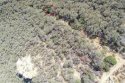
Drone photo -222 shows an area I wished to reach. The zoomed in drone photo -252, and several others consecutive photos of that area, show something that appears to be of red color. See the circles on these two attached images. Although my descent without a rope was manageable, had the slope been only slightly steeper, I would have needed a repelling rope or a camping shovel to dig some foot holds. (I did notice three electronic tea candles in the gully.) I made it about 2/3 down the gully to my target area when I came upon a large shrub spanning the entire width of the ditch. I was not able to pass that point and a machete would be needed to make way. I do plan on revisiting the lookout real soon with the necessary tools. Also, although the canopies of the shrubs make it impossible to see what is below them, once you get into the bushes and closer to the ground, the field of vision expands upto 20-30 feet.
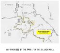
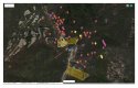
Finally, I've attached two maps of the search areas I was able to locate. The first, hand-drawn map may indicate the area around this gully was already searched, but the second Google map does not show that this area, nor where Matthew's hat was located, were searched. Was the gully area searched already?
For the sake of Matthew's family, I truly hope Matthew will come home, one way or another.