Some info on the trail.
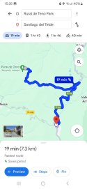
This trail is the ideal opportunity to cross the beautiful Teno Rural Park from east to west.

www.tenerifeon.es
That's helpful as I don't have my walking maps for the island to hand.
A couple of things to ponder:
- Manchester Evening News article mentions he intended to catch a bus back but he missed it. If that's correct then he should have been on a road when he set out that morning.
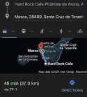
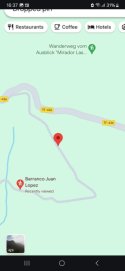
- Articles mention he was close (so not 'on', although phone locations aren't always precise) to the TF51 trail and above the village of Masca. That suggests that he left the road he was originally on for the trail.
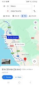
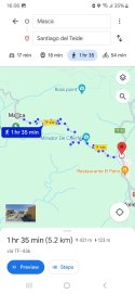
- The most likely place for that to happen would be (if he was heading south/southeast) on the TF436.
- It's windy road that runs north/south with the nearest villages being Las Lagunetas and Las Portelas. There is a bus that runs from those settlements that goes to Santiago del Tiede where it meets the TF1 major road and plenty of buses to get home.
- However the bus departures from those villages are such that - if the timings on the news article are correct - he'd have missed the early morning bus (circa 6.30am) with the next bus midmorning. (Circa 09.40am). That might indicate why he was walking.
- If he did start hiking the TF436 then the most likely turn off to the TF51 is at the Mirador Altos de Baranco. It's a popular tourist viewing spot, plenty of houses below you and the sign for the TR51 indicates only 3.6km to Casa de La Cumbre. (That name would indicate a house/village. However unfortunately it's the name for a barrranco or ravine).
A bit more specific information could put holes in some of the above.


 www.lancs.live