Malaysia airlines plane may have crashed 239 people on board #23

DNA Solves
DNA Solves
DNA Solves
Status
Not open for further replies.
Just look at the crisp clarity of this sat photo!

https://www.google.com/search?q=Geo...rg%2F2012%2F04%2Fpunggyeri042712%2F;1517;1098

and the ironies here stun, much clearer pics of nuclear power stuff is released to the public than images related to s "suppossed" search for survivors in an alledged plane crash .

Pretty wacko, no?

Actually, that can be relatively easily explained.

1: It’s far more likely that a satellite is ideally positioned (for surveillance) over land, than it is one would be ideally positioned over remote stretches of ocean. The better the position, the better the photos. That was discussed pretty heavily here early on.

2: Photos taken of land-based features are more likely to appear higher quality because there’s more detail and contrast to capture. An optical sensor has limitations, and trying to make sense of vast stretches of similar scenery (like big patches of ocean) is difficult so sensors can become confused, as can the software used to interpret the raw data.

3: The human eye and brain can better distinguish details when there’s some variety, as opposed to something with little variation like very small objects in a swath of ocean. If you were to place a photo of one of the nuclear sites from Google, next to a photo of a patch of ocean from the MH370 search, your brain is going to have an easier time deciphering the photo of the nuclear site.
 
Two years ago, researchers demonstrated that they could commandeer the controls of a remote-piloted drone by tricking it with fake GPS coordinates.....

.....rica's security and intelligence agencies are teaming up with airline manufacturers to defend against a catastrophic cyberattack that could cripple the air traffic control system, interfere with the computer systems used by modern aircraft,

....As part of a new program, which will be run from a federal facility outside Washington, U.S. government personnel will work alongside private-sector aviation employees.......... goal is to spot malicious hacker activity on computer networks could create entry points for hackers are installed on passenger aircraft.


....For years, cybersecurity experts and government officials have warned that the computer networks underpinning the U.S. air traffic control system could be penetrated by malicious hackers.

....There are a lot of attack surfaces there," said Fred Schwien, the director of Homeland Security at Boeing...

....center will be built at a Transportation Security Administration facility near Ft. Meade, Md., the headquarters of the National Security Agency and U.S. Cyber Command...

Cyber Command also would be involved in responding to a cyberattack on any critical infrastructure in the United States, including the air traffic control system.


...... new center "is going to make the information-sharing much tighter," said Schwien, the Boeing executive. "This will be a place where people will know each other and trust each other."

...Cyber threats to aviation are among the oldest and most feared,

.... the GPS system was "just the tip of the iceberg of a much bigger security issue we have in this country," Logan Scott, a GPS industry consultant..............

....former Homeland Security official, wrote last year that the hackable GPS system poses a risk for commercial aviation............

http://www.foreignpolicy.com/articles/2014/04/24/the_blue_screen_of_death_at_30000_feet

</SPAN></SPAN>
[ame="http://www.youtube.com/watch?v=mU3aDvryyeI&list=UUzznO4xSV8BKnUBPyswtCUw"]U.S to beef up security against airline cyberattacks - YouTube[/ame]
 
Is it odd that" bluefin" has done 12-13 missions and (as far as I know) there has not been one single picture of the ocean floor at all?
In such uncharted waters IMO they would've shown something on HLN. No one seems to be asking either. At least not the reporters I have listened to.
Moo

Sent from my LG-D801 using Tapatalk

From what I understand, the ocean floor in this area is very silty and murky.
I would imagine this would make it difficult to get proper images.
 
Is it odd that" bluefin" has done 12-13 missions and (as far as I know) there has not been one single picture of the ocean floor at all?
In such uncharted waters IMO they would've shown something on HLN. No one seems to be asking either. At least not the reporters I have listened to.
Moo

Sent from my LG-D801 using Tapatalk

I find that odd too now that you mention it. There was so much publicity about the Bluefin and waiting to finally release it to do its thing.

Welll.......It seems to be doing its thing and we can't get 1 lousy picture to look at.

They have to know we all are curious to see what it looks like even if it is barren murky mud. We still want to see what we have waited all this time for.

It is strange how CNN and other news sources dont seem to ask these kinds of obvious questions. I dont think the Bluefin is top secret or anything. It was used in the Air France disaster I believe and from what I remember we saw pictures of the debri on bottom from that.

I find it exremely odd.

If the pictures are coming out really lousy, I suppose I could understand them not wanting to embarrass themselves how bad it is working.

Heck even the guy who found the debris on the beach knew enough to give pictures out to media because he knew everyone wanted to see it.

Im sorry, but getting real frustrted lately and I refuse to accept any more "secret" stuff. Enough of that. Its time to be honest and find this plane and the poor souls on board.
 
If I&#8217;m not mistaken, there are no photos to show. Unless I missed the change, the Bluefin is searching and mapping using sonar, not cameras at this stage, right?
 
Todays Search


Joint Agency Coordination Centre
Media Release
26 April 2014&#8212;am

Up to 8 military aircraft and 11 ships are planned to assist in today's search for missing Malaysia Airlines flight MH370.

Today the Australian Maritime Safety Authority has planned a visual search area totaling approximately 57,311 square kilometres. The centre of the search area lies approximately 1584 kilometres north west of Perth.

The weather forecast for today is for isolated showers, with south easterly winds up to 20 knots, sea swells of two to 2.5 metres and visibility of one kilometre in thunderstorms and three kilometres in rain.

Early into mission 13 yesterday Bluefin-21 was recovered due to a software issue that required resetting. The AUV has technically sophisticated equipment and a reset is not uncommon. Overnight Phoenix technicians resolved the issue and mission 14 is now underway.

http://www.jacc.gov.au/media/releases/2014/april/mr038.aspx
 
My bad! I thought they were looking forward to having some sea floor pictures, but I do recall that it was not fitted with a camera.
I was under the impression it was more like a sonogram and the "pictures" came from sound waves.

I was wrong sorry.
Moo

Sent from my LG-D801 using Tapatalk
 
Not trying to say you are wrong, but, the phone calls made by the families to the passengers phones after the plane went missing, and the families hearing it ring IS possible without the cellphone being active, or powered on.
I've explained this before.
When the cell phone is turned on, it connects to the network and basically says hello network, i'm this phone and i'm connected. Some would call it a handshake, ping, or acknowledgement. Which is why the police and authorities are able to ping your cell phone and pull a GPS coordinates to find out where you are.
Now when you turn your cell phone off, it sends another message, basically saying i'm leaving the network and will no long be on to accept calls. So there will be no more ringing.
If you happen to pull your battery out or the battery dies, the phone has no time to send that goodbye message, and the network will assume the phone is still on and just not in network range, temporary signal loss, and to someone who is trying to call you, they will think you are ignoring their calls. Which is why the families still heard their loved ones phone ring when they called.

Also I've heard about people asking about the "find my phone" app. In order for that to work, you would need to have the cell phone in network range and with a data connection.
I just turned off my phone and then called it, and it rang and rang and would have kept ringing because I don't have voicemail service with my cell phone, but then my google voice voicemail picked up finally, so without voicemail it would continue to ring.
 
This is an example of a side scan sonar image (taken by the Canadian Navy). A pretty clear picture can be formed. But somehow I doubt the JACC will release any pics of their searches anyway. They don't seem to be releasing many pics lately ... even the recent debris photos were published because the finder gave his own pics to MSM, not because the JACC released them.

empress_sss_01.jpg


http://www.northernatlanticdive.com/empress_sss.htm
 
BEIJING: Dozens of relatives of passengers aboard missing Malaysia Airlines flight MH370 held an overnight protest outside the Malaysian embassy in Beijing demanding information from officials, two participants said on Friday.
The protest followed a chaotic meeting on Thursday between airline staff and relatives who have been waiting for nearly 50 days without any sighting of the plane, prompting police to step in to separate both sides.
About two-thirds of the 239 passengers aboard the missing plane came from China, and many of their relatives have waited with frustration at a hotel in Beijing for updates, often venting at airline or government officials who come to brief them.

http://www.freemalaysiatoday.com/ca...5/mh370-families-protest-at-malaysia-embassy/


"Tensions boiled over at a briefing on Thursday at a hotel where relatives are staying, after airline representatives said a Malaysian embassy official would not arrive to answer their often extremely combative questions.

"We want somebody from the embassy to come out and tell us why they didn't come," said relative Steven Wang.
He said about 100 people had waited outside the mission overnight.

Police fanned out around the embassy Friday morning.

Dozens of relatives had staged a noisy protest last month at the embassy - apparently sanctioned by Chinese authorities, who cleared streets for their approach - decrying Malaysian authorities and the national airline as "murderers"."

BBM :what:


http://www.sbs.com.au/news/storystream/mh370-malaysia-airlines-staff-held-families
 
This is an example of a side scan sonar image (taken by the Canadian Navy). A pretty clear picture can be formed. But somehow I doubt the JACC will release any pics of their searches anyway. They don't seem to be releasing many pics lately ... even the recent debris photos were published because the finder gave his own pics to MSM, not because the JACC released them.

empress_sss_01.jpg


http://www.northernatlanticdive.com/empress_sss.htm

Thanks for this example. You are correct that the Sidescan Sonar really does take "digital snapshots" or echos off the bottom but it does make a good "picture" of the bottom. It is different than a photograph but it is still a good picture nonethess. I am 100% sure they are obtaining these types of pictures of the bottom.

Its no different than a good Sonar Fish finder on a boat. You get a good picture or image of the bottom. It is just digitally done on a graph but shows the bottom outline and depending on quality of the Bluefin I am sure it is good sonar images of bottom.
 
BBM.
Some of us here on WS figured that it is/was a fire suppression bottle.
Specifically one from a Boeing plane.
But I guess authorities in Maldives have concluded it wasn't that but something else not related to the plane.
IMO, I don't think it was ever investigated.

My opinions only, no facts here:

My image did not post!!

Let me check its size and try again.
 
I think they were way too quick to discard the Maldives sighting of a low flying plane shortly after 6 AM. Its very possible that the plane was waiting for sunlight to try for an emergency landing. It could have been doing circles around maldives and when sun came up it tried for emergency landing near there. Are there any airports on Malidives because it could have purposely landed there too. Below is a map and I think its possible.

http://www.mapsofworld.com/maldives/maldives-location-map.html

Like someone else said, they saw a plane flying very low that they never saw so low before because of the roar it made. Multiple people saw it. Not just 1 person.


Yes Indeed there are airports on the Maldives! Info listed in Post #583 on this Thread, Page: 24. Please see listing there,
or for your convenience a very short recap here:

List of airports in the Maldives:
[ame="http://en.wikipedia.org/wiki/List_of_airports_in_the_Maldives"]List of airports in the Maldives - Wikipedia, the free encyclopedia[/ame]

Ibrahim Nasir International Airport:
[ame="http://en.wikipedia.org/wiki/Ibrahim_Nasir_International_Airport"]Ibrahim Nasir International Airport - Wikipedia, the free encyclopedia[/ame]
"Ibrahim Nasir International Airport (IATA: MLE, ICAO: VRMM), commonly known as Malé International Airport, previously known as Hulhulé Airport,
is the MAIN International airport in the Maldives. It is located on Hulhulé Island in the North Malé Atoll, nearby the capital island Malé.
Ibrahim Nasir International is well connected with major airports around the world, mostly serving as the main gateway into the Maldives for tourists.
Moreover, despite the upgrading of GAN Airport to international standard, Ibrahim Nasir International is currently the ONLY
INTERNATIONALLY ACTIVE airport in the country."

Gan International Airport:
[ame="http://en.wikipedia.org/wiki/Gan_International_Airport"]Gan International Airport - Wikipedia, the free encyclopedia[/ame]
"Gan International Airport (IATA: GAN, ICAO: VRMG) is located on the island of Gan in Addu Atoll (previously known as Seenu Atoll) in the Maldives.
First built by the Royal Navy, and transferred to the Royal Air Force as RAF Gan, it was a military airbase used during World War II and until 1976.
The British handed it over to the government and it was used as a domestic airport. Recently the airport has been upgraded to international standards
in preparation for international flights with the opening of tourist resorts in the area.
Gan International Airport (GIA) serves as a key tourism gateway to the Republic of Maldives and its luxury beach resorts and dive sites.
GIA is situated at the southern tip of the country, and allows international and domestic aircraft movements year-round."

List of airlines of the Maldives:
[ame="http://en.wikipedia.org/wiki/List_of_airlines_of_the_Maldives"]List of airlines of the Maldives - Wikipedia, the free encyclopedia[/ame]
Fore full/more Maledives Flight Information, visit http://www.fis.com.mv
:seeya:
 
BBM.
Some of us here on WS figured that it is/was a fire suppression bottle.
Specifically one from a Boeing plane.
But I guess authorities in Maldives have concluded it wasn't that but something else not related to the plane.
IMO, I don't think it was ever investigated.

My opinions only, no facts here:

As of today, I checked the main Maldivian news online, and I ascertain that the Maldivian authorities have not yet released any information about the supposed fire suppression bottle. Strange, isn't it? This apparent piece of random flotsam should have been identified a long time ago.

I saw several questions today on Websleuths about the object that washed up on a beach in the Maldives.

You know, if MH370 is not found around the current search sites (we need to wait at least a few more days to a week to know one way or another), it may become necessary to consider whether the plane simply flew west towards the Maldives. I am not promoting this theory, but the Maldives should at the very least, trump any northern route. Anyway, I have studied the metal sphere that washed up on a beach in the Maldives from every technical standpoint available to me, since the day it was found.

With a search that has spent a quarter of a billion dollars, I am perplexed that an expert representative of the search effort did not buy a plane ticket for several hundred dollars and fly to the Maldives immediately after this object was discovered. I am equally perplexed that once the mystery object was turned over to the Maldivian military, that we did not see almost immediate conclusive statements from associated parties (Maldivian authorities, competent scientists, airplane manufacturers) regarding the identity of this object. The mystery object (either made of stainless steel or titanium) looks somewhat weather-beaten and possibly too old to be associated with the disappearance of MH370. I cannot see any reason why this object was not studied and publicly dismissed within a day or two, like EVERY other piece of flotsam that has been found since the search first began in the Gulf of Thailand.

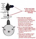
Below, I post a sketch of the object found in the Maldives, with my preliminary analysis. In order to be a fire bottle, it must be missing some parts (as shown in my sketch), and for some reason, it must also have not had a pressure gauge installed. The overall style of the object would be compatible with a fire bottle employed in the cargo hold.

In the one chance in a million that this object ever turned out to be from MH370, I could deduce a GREAT, GREAT deal.

Sleuth On!
 

Attachments

  • firebottle_final_for_post2.jpg
    firebottle_final_for_post2.jpg
    82.5 KB · Views: 28
Status
Not open for further replies.

Members online

Online statistics

Members online
147
Guests online
265
Total visitors
412

Forum statistics

Threads
609,222
Messages
18,251,173
Members
234,580
Latest member
Джои Соренсен
Back
Top