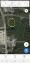
I'm trying to determine the actual location of where this UID was found. NamUs says 128 Rocky Point Road, Middle Island but there is not a sump there. The closest sump area is off of Bailey Rd behind the strip mall.
Water Resources of the United States—National Water Information System (NWIS) Mapper
This inactive well field is on property owned by SCWA.
ArcGIS Web Application
In searching more about this Bailey Rd. Well Field I found a
very interesting website with meticulously archived records about allege fraud concerning water quality testing in Suffolk County
http://www.gfxtechnology.com/Rn-Fraud.html
If you look on google street view this well field is gated (gates closed in 2013 shot, open in 2012)
For years there has been speculation that LISK could be some sort of public utility worker who could go undetected pulled over at dump sites. With this dump site being gated, I attempted to research SCWA personnel lists at these sites with no success (as well as reading old board meeting minutes and newsletters):
State employee salaries SeeThroughNY :: Payrolls
Interestingly, but probably not related is that the strip mall next to the well field to the West of this site on Rocky Point Rd is owned by an East Hampton mogul accused of having an affair with Martha Stewart
http://www.dailymail.co.uk/news/article-2426647/Socialite-47-tells-26-000-MONTH-allowance-cut-father-told-mom-affair-Martha-Stewart.ht
Some more specific location details could be very helpful here. I could be way off -maybe the gate is no longer there. If this UID was found in this area and it were still gated, that could direct our focus to a limited pool of individuals who would have had access to it,
recently!