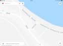
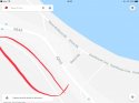
There is a little road that runs parallel to the High Street called Gortans rd. On streetview you can only accesss the eastern end and parts of it seem to unfinished (perhaps gravel). In early footage of the investigation forensics officers were working on this track and it runs along the woodland surround the Old Hotel. I wonder if it could have been the access point for the killer? There are long stretches without any houses and it connects back to High Street at the western end.
I do think a vehicle was used because, alive or dead, a child being carried in PJs (or a bag large enough to transport a child) is going to raise eyebrows.
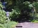
Here are some images of the road in question:
Map:
1B709E57-977D-444D-A6AA-19A200DF8CF5.jpeg
Satellite:
E295A38E-9F8C-4682-8F5A-8F691E150B62.jpeg
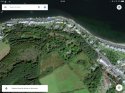
Eastern end (and limit of street view)
D406C2B2-A862-4A75-94CA-25E15D7B6BC6.jpeg
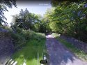
Western end:
09ED3BF1-467F-4AB5-A6B7-DBE7F7E765C8.jpeg