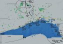
This is a tad off piste but in skimming the recent threads I've noted that maybe the people who are posting from out of area, and asking, for instance, about direct access to the Humber, could maybe do with something like this (apologies in advance to the Hullensians who will no doubt guffaw at its naivety)
The main roads into/out of Hull radiate like the spokes of a bike wheel - coming in from the west, Clive Sullivan way, which morphs into what used to be Hessle Road. Coming in from the north-west, Anlaby Road. The main north-south axis is Beverley Road (picked out in red). Leading off out to the north-east into the plain of Holderness is Holderness Road (the clue is in the title) and Hedon Road sets off due east past Hedon itself and eventually on to Spurn.
The crucial area for the case is inside that red ring with the crossroads of Clough Road and Beverley Road at its centre. That ring includes Haworth Avenue, the bench, Libby's street, and the Oak Road playing fields.
As far as the Humber waterfront is concerned, I've annotated the various access points and why, by and large, they are unsuitable. For my money, if Libby didn't float all the way down the River Hull and into the Humber, then the best bet would be the suggestion made by board member @winterhills who identified a place out at Paull which I have to say I was skeptical about at first but which draws me more and more - except that, for it to work:
If he did it the same night it's a long drive past places like the ferry terminal and BP's chemical complex out at Saltend which would undoubtedly have CCTV, and he would have to have known about the place in advance and known that the tide would be in. Or he waited and did it another night, which is even less feasible.
Anyway I offer this up in the hope it might be of some help to somebody. If not, just use it for origami practice.


")