- Joined
- Aug 9, 2012
- Messages
- 34,214
- Reaction score
- 340,177
Looking at the area maps (as I am not familiar), Mount Hotham is in the opposite direction from where Russell and Carol - and possibly the perps - live/d. This could be seen as another way for the perps to distance themselves from the crime. To travel 2½-3 hours further out of their way to dump evidence.
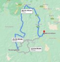
But there is a direct route/main roads from Mount Hotham back to the Drouin/Pakenham areas. So, an easy exit from the Mount Hotham area, IF the perps are known to Russell and Carol and came from their areas.


Google Maps
If I was the police, I would want to be searching those secondary roads between Wonnangatta and Mount Hotham - but what a task that would be.
But there is a direct route/main roads from Mount Hotham back to the Drouin/Pakenham areas. So, an easy exit from the Mount Hotham area, IF the perps are known to Russell and Carol and came from their areas.


Google Maps
If I was the police, I would want to be searching those secondary roads between Wonnangatta and Mount Hotham - but what a task that would be.
Last edited:
