

You are using an out of date browser. It may not display this or other websites correctly.
You should upgrade or use an alternative browser.
You should upgrade or use an alternative browser.
Australia Australia - Theo Hayez, 18, Belgian backpacker, Byron Bay, June 2019 #2
- Thread starter Beagle
- Start date
- Status
- Not open for further replies.
D
Deleted member 249471
Guest
Agree the ‘dirty’ pants aren’t relevant. We had this discussion a while back and the general consensus was that it’s a trick of light, exaggerating the natural folds and bagging around his knees, which exist but only slightly in other photos of him.
It’s night cctv footage after all, not proper well lit photography. You can also see the image is wildly distorted. Theo looks stout and full in the legs, yet tall and slender and back to normal in the images thereafter.
If you go back to images of him at the bottle shop, in some instances, he looks extremely gaunt in the face, but in other angles like his normal self. It’s just cctv. It can’t handle shadow.
Could be anything, including a mark being exaggerated in the dim light. It may be a water mark that dried, or a wine spill or something he cleaned up inside the bar. He had come from an hour long dinner and drinks at Wake Up surrounded by others. It happened before he went missing anyway and the police would’ve checked out his prior activity and interactions. Don’t reckon it’d be directly relevant just in my opinion.
Theo seemed quite confident in the direction he was heading. Considering the family have access to Google timeline I wonder can they tell what he was looking at on his phone when he took it out of his pocket.
Surely the guys discussed loosely where it is possible to buy recreational stuff especially as they bought beers and went to an offie.
It's been said here at the corner of marvel and tennyson is a place to hook up for stuff. We can't ignore this. Even if it's not for Theo himself then someone he's with. These seems the most plausible, uncomplicated explanation. If cops showed up they all might have ran as I said before 'off road' it explains the lost hat, the random Bush run and coming out on tallow beach relieved enough to relax and answer some messages. I'm still not convinced this messages aren't network stalls catching up. I for one always use YouTube as a torch rather than my phone torch because it wastes less battery.
From this point I think Theo tried to map to Wake Up. These are the ambiguous hours in afraid.
Yes, but he was in the company of people who do. It's a very common thing. Besides I think doing drugs and smoking pot are not seen as the save thing in today's culture. No more than drinking alcohol is for my generation. Its just that common.Don't forget all the information form TH's cousin that TH didn't do drugs and was a sensible person and traveler.
sparks030405
#TourismTrumpsTheo
- Joined
- Jul 15, 2019
- Messages
- 106
- Reaction score
- 338
Is starting to sound like undercover law enforcement (are they allowed to do entrapment?) more than gang chasing him, otherwise you would have thought he would call 000 or alert family for help. Makes sense to run off-road if police were chasing, and maybe he did try to sneak back via the lighthouse cliffs and stopped at CC to catch his breath and decide what to do next
Well, that would depend. If TH didn't ever smoke anything, why would he smoke weed? Why would he do it in the company of strangers? And in this situation. It seems like he had a place to be. It seems like he was running late, or he got a lift.
If others were using DMT or acid in the area, something could have gone very wrong. Their perception would be distorted. A stranger might be perceived as a threat. But I think it's something else. I lived there for 8 months. Granted 8 months is not a long time, but gangs. Most backpackers don't engage with the locals. I can't see him getting into trouble this way, and there's no suggestion of this being the situation in BB. Massive ice problem, and alcohol.
Well, that would depend. If TH didn't ever smoke anything, why would he smoke weed? Why would he do it in the company of strangers? And in this situation. It seems like he had a place to be. It seems like he was running late, or he got a lift.
I'm not saying he did. I'm saying he might have met up with someone who wanted to get a bag.
There's no love lost between tourists and cops.
- Joined
- Sep 6, 2015
- Messages
- 1,453
- Reaction score
- 7,655
Perhaps they dried? Maybe the stain was a liquid spill enroute to CM's. We are seriously lacking a narrative to Theo's 48 hours in Byron. He met people, connected, there should not be this gap. I can only guess that this will be a subject to future podcasts and I should not also be surprised to find more reasons for parallel investigation.
That is a really good suggestion about the stain being water that dried Rocket.
I dont think anyone has been able to confirm if it was a stain or simply the light playing tricks so we are all left to assume that it may have been a stain. maybe when leaving the hostel he grabbed quick drink of water from a bubbler or tap at the hostel and water split on him who knows.
He was definitely going somewhere and it wasn't to Wake Up. He may have felt very safe in Byron. He may have connected with someone in the bar or earlier who told him they were around. We still don't know what the WhatsApp messages are far as I know. They got messenger because it's linked to Facebook but not WhatsApp.
- Joined
- Sep 6, 2015
- Messages
- 1,453
- Reaction score
- 7,655
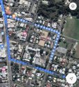
Theres also a lane and a street on the left side of that section of Tennyson Street that go straight to the populated main streets not far away.
The one thing I was able to do recently was recreate his movements from CM to end Tennyson.
I also recreated the suggested route from Kingsley to Wake up when he is seen looking at his phone. I put an address in equivalent to where he would been located on Kingsley at the time. The interesting thing is that on looking at both routes, it is a similar pattern. What I mean is the route he took to Tennyson if you flip and reverse it it looks very similar to the suggested from Kingsley to Wake up. I am talking only the route for the 500m odd. It made me think he was lost and possibly going the wrong direction which if he was under the influence drugs or alcohol he might have got his bearings mixed. It was to similar to ignore.
He was definitely going somewhere and it wasn't to Wake Up. He may have felt very safe in Byron. He may have connected with someone in the bar or earlier who told him they were around. We still don't know what the WhatsApp messages are far as I know. They got messenger because it's linked to Facebook but not WhatsApp.
“The last thing that can be said for certain about Theo’s location from Google is that he was at Cosy Corner at 12.05am. Further use of his phone after this time supports the theory it was Theo, not someone else with his phone.
At 12.20am, his phone sent a reply to a friend on Facebook Messenger in French. It was a continuation of an earlier conversation about an upcoming tour of Australia by the band U2. “Ugh, in September or something?” Theo’s message read.
At 12.55am, his phone also sent a WhatsApp message to his stepsister Emma in Belgium. It, too, was a reply to an earlier message and had a kiss emoji with one word in French — “Merci”.“
NoCookies | The Australian
Theo seemed quite confident in the direction he was heading. Considering the family have access to Google timeline I wonder can they tell what he was looking at on his phone when he took it out of his pocket.
Surely the guys discussed loosely where it is possible to buy recreational stuff especially as they bought beers and went to an offie.
It's been said here at the corner of marvel and tennyson is a place to hook up for stuff. We can't ignore this. Even if it's not for Theo himself then someone he's with. These seems the most plausible, uncomplicated explanation. If cops showed up they all might have ran as I said before 'off road' it explains the lost hat, the random Bush run and coming out on tallow beach relieved enough to relax and answer some messages. I'm still not convinced this messages aren't network stalls catching up. I for one always use YouTube as a torch rather than my phone torch because it wastes less battery.
From this point I think Theo tried to map to Wake Up. These are the ambiguous hours in afraid.
“Google’s My Activity also reveals Theo repeatedly used Google Maps after leaving Cheeky Monkey’s.
Each time he was searching for directions to his hostel, Wake Up! at Byron’s Belongil Beach, but he was going the opposite way.”
(btw Google maps directions from Kingsley Street to Wake Up take you up Tennyson Street.)
NoCookies | The Australian
Attachments
Is starting to sound like undercover law enforcement (are they allowed to do entrapment?) more than gang chasing him, otherwise you would have thought he would call 000 or alert family for help. Makes sense to run off-road if police were chasing, and maybe he did try to sneak back via the lighthouse cliffs and stopped at CC to catch his breath and decide what to do next
But that would be documented on the police system and known.
WOAH! Maps take you through tennyson St to Wake up? So why all the confusion as to why he went this way?“Google’s My Activity also reveals Theo repeatedly used Google Maps after leaving Cheeky Monkey’s.
Each time he was searching for directions to his hostel, Wake Up! at Byron’s Belongil Beach, but he was going the opposite way.”
(btw Google maps directions from Kingsley Street to Wake Up take you up Tennyson Street.)
NoCookies | The Australian
Why would maps take you this way? Is it quicker walking? It doesn't appear to be from aerial view. It seems counter intuitive.
He's only going the opposite way when he hits trouble at the top of tennyson from what you tell me. If hes correctly following maps to Wake up by tennyson then he's going the right way.But that would be documented on the police system and known.
He could have met someone on Kingsley or tennyson who left the bar before him, that he recognised or remained alone. Either way at the top of tennyson he's moving fast in the opposite direction and since we're happy with supporting evidence he made it to cosy corner relaxed enough to communicate online we must assume he went voluntarily if haphazard. Burger quiz seems to be released at regular slots with several posted on 31st May. How he might listen on beach is difficult to understand. I think he may use screen for lighting purposes. Have several tabs open and if video is playing screen will stay lit but chrome or safari will sleep. Is it possible to know if Theo's phone connected to Hot Spot? Will analytics show this I wonder?
sparks030405
#TourismTrumpsTheo
- Joined
- Jul 15, 2019
- Messages
- 106
- Reaction score
- 338
Makes me wonder if he was in an Uber and questioning direction he was being taken, but then again, he seems to want to be at CC“Google’s My Activity also reveals Theo repeatedly used Google Maps after leaving Cheeky Monkey’s.
Each time he was searching for directions to his hostel, Wake Up! at Byron’s Belongil Beach, but he was going the opposite way.”
(btw Google maps directions from Kingsley Street to Wake Up take you up Tennyson Street.
NoCookies | The Australian
WOAH! Maps take you through tennyson St to Wake up? So why all the confusion as to why he went this way?
Why would maps take you this way? Is it quicker walking? It doesn't appear to be from aerial view. It seems counter intuitive.
Because the obvious or expected route is to step out of the bar and walk straight up the Main Street into town then northwards to the hostel. Simple and straightforward.
Instead he came out of the bar and walked down the side street away from the main strip.
Maybe he was wobbly.
Maybe he was just meandering around the block to waste time and pull himself together.
Maybe he came in that way (from Kingsley) and just went out the same way. Did they get a lift to the bar or walk? Were they dropped off on Kingsley Street perhaps?
Anyway he was constantly looking for how to get back to Wake Up from the moment he left Cheeky’s.
But why go up Tennyson and not Middleton (the first street off Kingsley on the left)?
The other thing is that route to the Milne Track is very precise. You have to accurately wind through a few residential streets and between homes to navigate finding the entrance to (by the looks of it) a pretty dark, deserted, overgrown and eery path. This is what makes me strongly suspect he was with someone who knew exactly the way to go.
- Joined
- Jul 18, 2019
- Messages
- 91
- Reaction score
- 332
Unlikely he was in a car as he cut through the sports field, now if you look at the red return line coming back from Tennyson (as published by The Australian) he veers to the opposite side of the road (if this line is accurate). Now I had a look on satellite view and where he enters the sports field is a small gate, the rest is fenced. So would he be able to see this gate at night? And why not stay on that side of the road if he intended going through this way? Why walk and veer off on the other side then decide to cross over? Was he able to see this gate at night? If not then he was with someone or someone was with the phone and knew exactly where the gate was. Ok this is what confuses me some as well, he is said to have been looking at google maps while heading to Cosy. Ok how would he manage to be running and googling at same time, especially in the dark he would need to see where he is going, would be difficult to be running and looking at phone. Unless he was a passenger getting doubled on a bike, motorbike? The red line leads all the way from Tennyson to Cosy and most of it is not accessible by car but a bike or motorbike could go through there, but possibly too was running and used that kind of terrain deliberately if someone in a car was after him, though would make more sense to go and get help from a nearby house. Nothing seems to fit. I do not believe there was any party at Cosy either as if more than a few people there someone would have surely talked. If he/they went to see if there was a party well still does not explain why be in such a hurry and risk walking through scrub like he did, or his phone did. It's all so way out, way out of his character, way out of logical thinking, and this is the reason I think it is very possible someone else was with his phone. That makes more sense, someone in a hurry to take the phone out of the area by taking the most private route.
- Status
- Not open for further replies.
Similar threads
- Locked
- Replies
- 997
- Views
- 104K
- Replies
- 690
- Views
- 131K
- Locked
- Replies
- 1,345
- Views
- 228K
- Replies
- 2
- Views
- 3K
- Replies
- 2
- Views
- 1K
Guardians Monthly Goal

Goal Reached! We hit our target of 75 new Guardians!
New stretch goal: 100!
Our goal for the month is 75 new Guardians members to sign up. Have you been thinking about becoming a member?
Click here to find out how!
Online statistics
- Members online
- 77
- Guests online
- 1,108
- Total visitors
- 1,185
Totals may include hidden visitors.
Forum statistics
Community Rules
-
Be CivilTreat all members with respect. No personal attacks, harassment, or inflammatory language.
-
Victim FriendlyAlways show respect for victims and their families. No victim blaming or insensitive speculation.
-
Fact-based SourcingProvide credible sources for claims. Distinguish between verified facts and personal theories.
-
Social Media UseDo not post direct links to personal social media profiles of private individuals.
-
Copyright and PaywallsDo not copy full articles. Summarize and link to the original source instead.
-
Privacy and Personal InformationDo not post personal information such as addresses, phone numbers, or workplaces.
-
Registered Sex-OffendersDo not name or speculate about RSOs unless officially named in connection to a case.
-
Stay On TopicKeep discussions relevant to the case or topic at hand. Avoid off-topic tangents.
-
Accounts, Moderation, and DisputesOne account per person. Contact moderators privately for disputes or concerns.
-
Solicitation and FundraisingNo solicitation, fundraising, or promotion of personal ventures without approval.