- Joined
- Jul 8, 2012
- Messages
- 14,657
- Reaction score
- 138,314
Wow, just noticed it was over 8km away. How big was the search area for William again?
He travelled 2.6667 klms per day.
We see this often how young children can travel many klms away.


Wow, just noticed it was over 8km away. How big was the search area for William again?
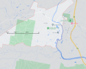
No, but this gives an idea of the distance (2.67km):Does anyone know how to show a 2.6 klm radius of 48 Beneroon Drive please?
At least. He might have walked in circles, backtracked etc, or not walked all three days.He travelled 2.6667 klms per day.
We see this often how young children can travel many klms away.
Wow, just noticed it was over 8km away. How big was the search area for William again?
18 square kilometres would be a radius of about 2.4km. Since a radius implies a circle, a 10km radius implies coverage of 314 square kilometres. I don't believe they searched anything like that amount of country. They probably searched some spot areas 10km from the start point in addition to the 1.5-2.5km radius circle.Police divers were called in to scour dams near the home, as the search, which widened to a 10 kilometre radius, became increasingly urgent on its third day.
However police concentrated on a 1.5 kilometre radius of the house, including dense scrub land.
Missing William Tyrell, 3, 'picked up by a car' police now believe | Daily Mail Online
This article says that the initial 10 day search covered 18 square kilometres.
https://www.theaustralian.com.au/ne...d/news-story/54f3086f0b252c56442ceac31763ddd9
Hi pkwis .... this is what has been reported about RP's car movements (with accompanying CCTV pics).
William disappeared on Sept 12th.
A recent document says in the two days after William vanished, Porter's car was recorded passing the Kew southbound camera on the morning of September 13, 2014, and the north- and south-bound cameras at Port Macquarie, the next day.
Significantly, investigators have also obtained evidence placing Porter at Port Macquarie Hospital the day William was last seen in the foster nanna's yard.
An undated police note signed by Detective Senior Constable Ari Barr said: 'Hospital records show that on the 12th September 2014, Porter was at dialysis at Port Macquarie Hospital between 9am and 3pm.
Porter's car wasn't picked up by highway cameras between his Wauchope home and the hospital that critical day.
But detectives suggested Porter had likely just used an alternative route, the Oxley Highway, to attend his clinic.
William Tyrrell abduction: Probe after dying man's confession | Daily Mail Online
It's not quite clear but I think a southbound camera means a camera in the southbound lane, so the car was travelling south at the time. Where do you think the camera was? I suggest it's at the north-most end of Kew. Are there cameras on this?Thanks South Aussie. That is great information.There is still my question as to where Porter accessed Pacific Highway to have the vehicle caught on cctv cameras as you have to drive under the said overbridge for that to happen. As far as I know you can't get onto Pacific Hwy unless you use an on ramp as it is a dual lane Hwy with wire barriers on north bound and south bound sides so that blocks access from bush tracks. IMO. From cursory google earth checks St John's south of Kendall appears to be the 1st place south of Kendall where you can drive onto Pacific Hwy. May be a local can post and let us know.
This could mean William was taken south or Porter was full of bull and used to put out a false story. IMO
Did they prove Porter was driving the vehicle when the cctv capture happened. Or is it possible number plates were swapped between same make and model of vehicle?
To get onto Pacific Hwy on ramp from where William disappeared from Google Earth directions take you down Laurel St which from memory is where that old man says he saw the 2 vehicles one with William in the back.
No, but this gives an idea of the distance (2.67km):
I forgot to add the link for the image and it's too late to edit. Google MapsIt's not quite clear but I think a southbound camera means a camera in the southbound lane, so the car was travelling south at the time. Where do you think the camera was? I suggest it's at the north-most end of Kew. Are there cameras on this?
View attachment 316879
It's possible someone other than Porter was driving his car, and it's possible he was confused (he was very sick) and the trip north with William didn't happen or didn't happen that Saturday.
bbmHi pkwis .... this is what has been reported about RP's car movements (with accompanying CCTV pics).
William disappeared on Sept 12th.
A recent document says in the two days after William vanished, Porter's car was recorded passing the Kew southbound camera on the morning of September 13, 2014, and the north- and south-bound cameras at Port Macquarie, the next day.
Significantly, investigators have also obtained evidence placing Porter at Port Macquarie Hospital the day William was last seen in the foster nanna's yard.
An undated police note signed by Detective Senior Constable Ari Barr said: 'Hospital records show that on the 12th September 2014, Porter was at dialysis at Port Macquarie Hospital between 9am and 3pm.
Porter's car wasn't picked up by highway cameras between his Wauchope home and the hospital that critical day.
But detectives suggested Porter had likely just used an alternative route, the Oxley Highway, to attend his clinic.
William Tyrrell abduction: Probe after dying man's confession | Daily Mail Online
thats a very interesting question ....I hope someone can answer that , as I'd love to know that too.bbm
Hearing "Wauchope" I'm remembering lovely TJ, who also lived there.
Do FA and TJ know each other? Did RP and TJ know each other?
According to TJ and this article they only met in prison - Grafton jail. However the inquest heard that the Jones home in Wauchope was on the same street as FA's son in law.bbm
Hearing "Wauchope" I'm remembering lovely TJ, who also lived there.
Do FA and TJ know each other? Did RP and TJ know each other?
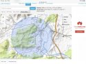
TGY, I tried to do it using a site I came across. I could do a 2.5km radius. But the screenshot couldn't be zoomed in without losing the boundary in the pic.Does anyone know how to show a 2.6 klm radius of 48 Beneroon Drive please?

That’s what I can come up withTGY, I tried to do it using a site I came across. I could do a 2.5km radius. But the screenshot couldn't be zoomed in without losing the boundary in the pic.
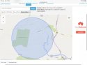
This is the website
2.5KM From Home
And you can search and pin an address.
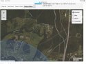
View attachment 317515
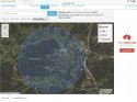
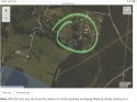
Here are better images of the 2.6km radius around 48 Benaroon Drive. I posted one above but it was kinda obscured but the “use two fingers to move” words Does anyone know how to show a 2.6 klm radius of 48 Beneroon Drive please?