AZ AZ - Jiyeon Lee, 33, Taehee Kim, 59, and Junghee Kim, 54 Missing After Leaving Grand Canyon

CrimeDawg123

Well-Known Member
Joined
May 6, 2016
Messages
3,083
Reaction score
27,659

Family of 3 missing after leaving Grand Canyon and driving through winter storm​

A family of three has gone missing in Arizona after leaving the Grand Canyon and driving through a winter storm, officials said.

The Coconino County Sheriff's Office is seeking currently seeking information on the whereabouts of a family of three -- Jiyeon Lee, 23, Taehee Kim, 69, and Junghee Kim, 64.

The family was last known to be traveling by road in a white BMW with California license plates when they were on vacation from the Grand Canyon area to Las Vegas last Thursday, police said, and GPS information from the rental car shows it was last traveling on westbound Interstate 40 at around 3:30 p.m.

 
1742485657669.webp

 
Here is a google map of the route driving from the Grand Canyon to Las Vegas.

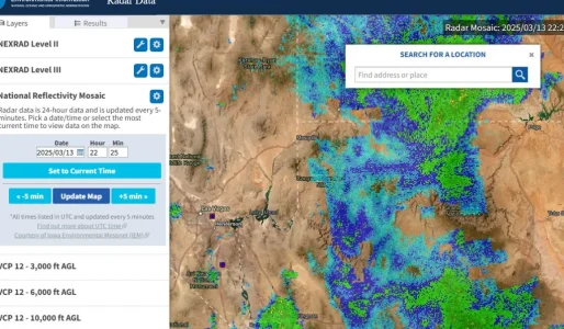
Attached is a screenshot of the weather radar in that area the afternoon of the 13th (last Thursday). The time is in zulu time, mid afternoon local time. It's a pretty large storm. The california plates may be a rental car - do we know what State they were from, or were they visiting from out of the country for vacation? The NOAA radar map. Radar Data
 

Attachments

  • grand canyon to LAS radar thursday afternoon 13th.webp
    grand canyon to LAS radar thursday afternoon 13th.webp
    149.6 KB · Views: 25
It seems odd that they can have such detailed GPS information from the rental car, but then not know where they are. I assume the area of the last GPS ping has been well searched. But is it possible for these things to be turned off? Or run out of battery? Or break in a collision? Or just lose signal? You would think if there was a crash and the GPS broke then that would be reflected in the data in some way, but maybe not.
 
It says their car’s GPS showed the family was last on the I40 westbound around 3:27 pm. And it says a big multi-vehicle crash happened on the I40 that day. But then it says they don’t know if they were involved in the crash??
The multi-vehicle accident happened Friday March 14th at 1:30pm near Holbrook, AZ which is about 126 miles east of where they would have gotten onto I-40 leaving the Grand Canyon almost 24 hours prior. And all 5 victims who passed in the crash have been identified as of reporting yesterday. No idea why they would say they don't know if they were involved. Seems pretty clear at this point they weren't involved, seeing as there are no unidentified victims from the crash.

And the timeline doesn't make sense. If they were still driving around almost 24 hours later, the GPS should have picked up on that, I think whatever happened took place before whenever the next update would have been to the GPS. Depending on the model of GPS data can be tracked real time or send data at customizable set intervals. If it was real time and the last update was 3:27pm, then something happened at that time to disable it. If it sends data at set intervals I don't see it being set at more than 1 hour intervals as it wouldn't be helpful to locating a lost/stolen car. So at most I think something happened within an hour of 3:27pm to disable the GPS. I also don't think it would be easy to disable because it wouldn't be helpful in recovering stolen cars if thieves could just turn it off. They would also typically have an internal battery so they still work when the car is off, but the internal battery could have been dead if the device were older. I think a crash could disable it depending the location of the device and how bad the crash is.
 
Is there water near the last ping? Unfortunately a crash into a body of water could be a likely reason to lose signal.
I’m local here in Vegas, coincidentally just got back from taking some relatives back and forth to the Grand Canyon. There is no logical place they would have ended up in water. It’s desert, minimal water. There are lakes in the Flagstaff area, but there’s nothing along I-40.

The storm was severe and I would guess they lost control and went off the road somewhere, obstructed by trees.
 
It says their car’s GPS showed the family was last on the I40 westbound around 3:27 pm. And it says a big multi-vehicle crash happened on the I40 that day. But then it says they don’t know if they were involved in the crash??
When there are storms in that area, cars are sliding all over the place until they plow or shut the road. The road gets dangerous very quickly. The article says there were several crashes that day. I am inferring from the report that authorities don’t know if they may have been involved in a minor accident and perhaps continued on their way. If they can’t verify they were not involved in any crash, it could have led to another vehicle issue later.
 
The multi-vehicle accident happened Friday March 14th at 1:30pm near Holbrook, AZ which is about 126 miles east of where they would have gotten onto I-40 leaving the Grand Canyon almost 24 hours prior. And all 5 victims who passed in the crash have been identified as of reporting yesterday. No idea why they would say they don't know if they were involved. Seems pretty clear at this point they weren't involved, seeing as there are no unidentified victims from the crash.

And the timeline doesn't make sense. If they were still driving around almost 24 hours later, the GPS should have picked up on that, I think whatever happened took place before whenever the next update would have been to the GPS. Depending on the model of GPS data can be tracked real time or send data at customizable set intervals. If it was real time and the last update was 3:27pm, then something happened at that time to disable it. If it sends data at set intervals I don't see it being set at more than 1 hour intervals as it wouldn't be helpful to locating a lost/stolen car. So at most I think something happened within an hour of 3:27pm to disable the GPS. I also don't think it would be easy to disable because it wouldn't be helpful in recovering stolen cars if thieves could just turn it off. They would also typically have an internal battery so they still work when the car is off, but the internal battery could have been dead if the device were older. I think a crash could disable it depending the location of the device and how bad the crash is.
Is this the multi-vehicle accident, or is this a different one? This one looks horrible!! A 22- car pileup on the I-40 in AZ, it says. Wow.

 
If they disappeared into water, could they have crashed into the Colorado River anywhere or Lake Mead? Especially if the weather was dicey?

It's been many, many years since I drove the route from Las Vegas to the South Rim & back, but it's a longer drive than you anticipate. And other than the Lake Mead/Hoover Dam area, mostly I remember lots & lots of flat roads & dirt. (Around Lake Mead/Hoover Dam, though, it was mountainous driving. I remember thinking that I would not want to be driving in bad weather along there, especially with so many semis on the road.) Of course it could have changed quite a bit since then too. Imo.

1742539018833.webp


Is this the multi-vehicle accident, or is this a different one? This one looks horrible!! A 22- car pileup on the I-40 in AZ, it says. Wow.

My goodness! Between this, the deadly Wyoming tunnel crash, and the dust storm crashes it's been a tough time on the roads. I didn't even hear/see about this one.
 
If they disappeared into water, could they have crashed into the Colorado River anywhere or Lake Mead? Especially if the weather was dicey?

It's been many, many years since I drove the route from Las Vegas to the South Rim & back, but it's a longer drive than you anticipate. And other than the Lake Mead/Hoover Dam area, mostly I remember lots & lots of flat roads & dirt. (Around Lake Mead/Hoover Dam, though, it was mountainous driving. I remember thinking that I would not want to be driving in bad weather along there, especially with so many semis on the road.) Of course it could have changed quite a bit since then too. Imo.

View attachment 572662

My opinion is they could not end up in water. Their GPS would have pinged if they made it as far as Lake Mead and the interstate (I-11) would have noticeable signs if they went off the bridge over water. At that time, someone would have witnessed a crash at the Colorado River or Lake Mead.

The storm and slippery roads near the Grand Canyon (Williams and I-40) are much more likely to blame based on GPS and the storm. It barely rained, if at all, at Lake Mead.

I am hoping they are holed up in Vegas having fun, although I don’t think it’s likely.
 
If that big crash on I-40 closed the highway, I wonder if their GPS took them on an alternate route. They may not have even realized that they were being diverted by their mapping software.

In that part of the country, there aren't a lot of alternate routes, and it's possible they could have found themselves on a forestry road. Those can get pretty hairy if you're not accustomed to driving on them, and you could run into some bad situations if you're not prepared. For example, if they ran out of gas while in the middle of nowhere.

Edit - Also, once you're off the highway there may no longer be a cell signal. That could be why there hasn't been a GPS ping since the 13th.
 
Last edited:
If that big crash on I-40 closed the highway, I wonder if their GPS took them on an alternate route. They may not have even realized that they were being diverted by their mapping software.

In that part of the country, there aren't a lot of alternate routes, and it's possible they could have found themselves on a forestry road. Those can get pretty hairy if you're not accustomed to driving on them, and you could run into some bad situations if you're not prepared. For example, if they ran out of gas while in the middle of nowhere.

Edit - Also, once you're off the highway there may no longer be a cell signal. That could be why there hasn't been a GPS ping since the 13th.
I was thinking of this when I saw the massive wreck seems to have coincided with the time the GPS stopped transmitting info. It’s a very good theory. I’m sure LE is looking into this, but who knows where they may have ended up in snowy conditions. They wouldn’t be able to see the “road,” if it was a road.

Mapping software has gotten much better in recent years, so I doubt it would send them into very unsafe conditions in that area, but if they were lost with limited cell coverage, they may have ended up anywhere.
 
Daily Mail article with some new info.


The sheriff's office is pursuing the GPS re-routing theory.

According to the sheriff's office, GPS data showed the BMW traveling westbound on I-40 at exactly 3:27pm on March 13 - the exact same highway and same time where the massive crash occurred.

'It was our concern that because of the weather conditions on that day and that major accident, their GPS may have rerouted them,' the sheriff's office told Fox 10.

'And if you've ever traveled up in northern Arizona, when you get rerouted, sometimes GPS will reroute you out into a forest service road without knowing that weather conditions are harsh.'
 

Members online

Online statistics

Members online
145
Guests online
572
Total visitors
717

Forum statistics

Threads
625,536
Messages
18,505,776
Members
240,812
Latest member
seanbrwh
Back
Top