Wow, this was very interesting to read. First off, welcome to Websleuths and your input it is very interesting and welcomed. I have a couple of questions for you.
(post trimmed by me)
Hi evey,
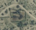
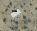
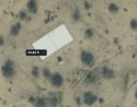
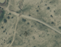
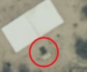
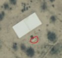
Thank you for the welcome and the engagement with my comment! You bring up some good questions, to me the rectangle looks like a door that almost appears to be partially sunken into the ground. I measured it with the tool and it was estimated to be 4 feet wide and about 7 feet tall. When I measured my own door at home it was 3'6" wide and 6'10" tall, so based on that I figured that's what it could be. It may also be stairs down to an entrance, I'm looking at the lighter shaded area towards the "front" of the black rectangle. I looked at a bunch of different properties/RVs/sheds at different angles in the Artesia area using the same program and with every one of them had some sort of a shadow. To me, it really looks like its flat on the ground. I am attaching some more images where you can see the rectangle a little better, let me know what you think.
Hey, hi, hello, and howdy; long-time reader, first-time poster. I've been following Artesia Doe's case for a while.
I respectfully disagree with the idea of these structures being bunkers.
Simply put, even if these buildings
were bunkers, their sheer inaccessibility would make them frustratingly inconvenient. The area is
very remote. Artesia itself seems to be barely more than a cluster of trailers; the only way out of town is a single two-lane road. The area is, however, home to a federal prison (as well as an Eastern Orthodox convent and an observatory) and doubtless has more law enforcement presence, for that reason alone, than countless similarly desolate places across the Southwest. There is nowhere to restock a clandestine bunker, and any regular visits by car would be noticed, either by bored locals, by the nuns, or by observatory staff tracking light pollution. Why not just hide out elsewhere?
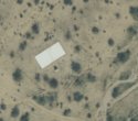
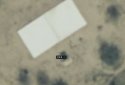
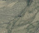
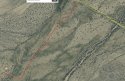
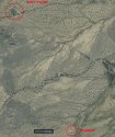
My second point- looking at the structures themselves, I don't see any facilities necessary for long-term use. There are no solar panels or wind turbines to provide power to the buildings. All are situated near small streams, as indicated by zigzagging lines of dense vegetation, and have a spring-fed trough or float tank (the "stairs" TheHighestPriestess is seeing) but don't have filtration systems that would make the water drinkable. The only plants are squat desert shrubs, and there are no gardens or greenhouses that could grow edible plants. Any human living in these buildings would be subject to 100-degree days and freezing nights with no heat, power, or drinkable water.
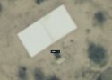
So, what are these places? Well, here's my opinion: livestock sheds. They are all roughly identical in terms of facilities: a rectangular building with an outdoor trough, surrounded by a square corral and accessed by dirt road. Each is in the middle of remote scrubland, but near enough to grazing that the herd won't wander too far. It's perfect for the occasional roundup by a rancher who otherwise lets their animals graze free-range. I can't access Graham County's land records, but chances are these are ranches raising cattle and/or sheep.
I wonder if the nuns at St. Paisius noticed anything. Sometimes convents will give alms-seekers shelter or money to get back on their feet. According to their website, there is a guest quarters open for free, provided you observe the sisters' schedule and do chores alongside them. Artesia Doe could have stayed there prior to her death. I've also read on another site (not sure if I can say where) that drifters sometimes gather at the hot springs near Safford. If Artesia were a runaway, she may have been killed there and her body transported to where it was dumped. Alternatively, she may have left (or been on the way to) the hot springs, been at the shed for a rest, and her killer attacked then.
I hope Artesia Doe's murderer is found, as well as her name. Nobody deserves to die like she did.