38,272 plants and 12 guns, yes, but 0 murders and, hence, no MSM coverage.
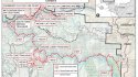
The murder woulda been five Sundays before the family took their walk, in the vicinity of their primary residence, in what the SO spokie described as a ‘cartel-type hit and major trafficking operation’.
Wow -- thanks for link to this Sept 2, 2021 "Inside the Office w/ Sheriff Jeremy Briese.
Here's the relevant portion of the YT transcription:
09:54
is august 9th august 10th you may have
09:57
seen a lot of activity in and around
10:01
your areas but
10:03
probably to this date this would be one
10:05
of the largest uh marijuana
10:08
operations that the sheriff's office
10:10
conducted it was a two-day operation
10:13
we utilized many allied resources and
10:16
and individuals um to
10:19
combat this as you know we've talked
10:21
about this from
10:23
you know just the mass quantities are
10:26
you know trying to keep up keep up with
10:27
everything so
10:29
for your uh viewing pleasure the the
10:32
total for both days we issued 23 search
10:36
warrants eradicated 38
10:39
272 plants confiscated 2 550 pounds of
10:43
processed we arrested 14 individuals
10:47
we took off 12 guns
10:49
in addition to that we had
10:51
methamphetamine sales cocaine sales
10:54
child endangerment animal cruelty
10:57
using a juvenile for the purpose of
10:59
cultivation
11:01
and then your other marijuana licensing
11:03
violations county code violations and
11:06
environmental crimes so hats off to the
11:08
marijuana enforcement team and sergeant
11:10
mike charman for coordinating all that
11:12
that was a lot of work
11:14
by everybody
11:15
and it was done safely and we got the
11:18
job done so thank you guys for that
11:21
and do we have any winners on shannon
11:24
clark
11:25
clark all right so our next winner is
11:28
shannon myers clark
11:32
the answer
11:33
was amigo del oro
11:37
or otherwise known as our golden friend
11:40
so your tickets are here thank you
11:44
and we will get into a couple other
11:46
i know uh highly looked at cases first
11:49
we will talk about the shooting at the
11:51
fifth street parking lot um the suspect
11:54
was a kenneth patterson
11:56
shot an another adult male in the back
11:58
fled the scene
12:00
after hours um detectives and
12:03
investigators worked through the evening
12:06
and safely kenneth turned himself in and
12:09
he remains in custody as the victim is
12:11
in the hospital
12:12
you know this incident was
12:15
in our downtown very scary but everybody
12:18
responded quickly and everything was
12:20
handled appropriately
12:21
and we had a quick conclusion for that
12:25
and
12:26
the big case probably everybody's
12:28
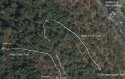
wanting to know about is our garrish
12:31
chung case and that is um
12:33
the family that was found deceased at
12:35
the
12:36
outside the heights cove area
12:38
and you know this case obviously got
12:41
national or international media
12:42
attention so
12:44
you know first our hearts are out like i
12:46
said from the beginning the family and
12:48
the friends um
12:50
you know our detectives are working when
12:52
i say working around the clock they are
12:54
working around the clock
12:55
uh working with so many different
12:57
agencies to try to you know find answers
13:01
establish timelines um
13:04
we have
13:06
i would say
13:08
lab testing lab facilities for all
13:10
different things
13:12
all across the nation there everybody's
13:14
helping us out including the fbi they're
13:16
helping us out a lot
13:18
um
13:19
and so
13:20
as we move through this case we are
13:22
going to continue to always be there for
13:24
the family first and then we're always
13:26
going to continue to update you the
13:28
public
13:29
um what's going on what what is
13:31
happening i know there was a lot of talk
13:33
with the
13:35
poisonous algae blooms in the river
13:38
those
13:41
tests some of those tests have came back
13:43
and
13:44
we have reported that as well to their
13:46
state water boards um there was
13:49
there was a um what would you call that
13:52
a positive test for
13:53
the um
13:56
what's that called ana
13:57
anatoxin a
13:59
and it was a high level so we have
14:01
definitely pushed that information out
14:03
as well for others in the area and your
14:06
animals um not saying that that is a
14:09
cause but
14:10
through investigation we have identified
14:13
that that is present in the in the river
14:16
so
14:17
you know for the public safety side we
14:19
wanted to get that message out at least
14:21
we do know it is present working with
14:24
you know our all our state and federal
14:26
partners and make sure everybody has
14:28
that information as quickly as we can
14:30
and
14:31
so with that case um everybody is
14:34
working very hard um and we'll continue
14:36
to update on that
14:39
and i think we are going to go into
14:42
our
14:48
rodeo tickets