Found Deceased CA - Rachel Nguyen, 20, & Joseph Orbeso, 21, Joshua Tree Nat'l Park, 27 July 2017 #1

Status
Not open for further replies.
  • #521
  • #522
  • #523
"Other JOSAR members, with canines, focused on Smith Water Canyon. Officials say the last ping from Joseph Orbeso’s phone was recorded, at 4 p.m. July 27 in a triangulated area around the canyon, Orbeso said."
They previously stated the ping was near the car, so that does give us an intersection point. However, Smith Water Canyon is southwest of the car, and SAR stated the prints headed north away from the car. Hmmmmm

https://www.google.com/maps/dir/Smi...1!1s0x80dadcba9e1bf6ad:0x23fc83874d27ee16!3e0

attachment.php
 

Attachments

  • IMG_9301.jpg
    IMG_9301.jpg
    92.8 KB · Views: 451
  • #524
Yet another search by the amazing T Manhood... this time, Smith Water Canyon. I wonder if there is still water out there in July/August.

http://www.otherhand.org/home-page/search-and-rescue/searching-for-bill-ewasko/jt54-10222013/

Taking his theories about a different person and applying to RN & JO, it looks something like this:
  • <snip>... heading to Smith Water Canyon to reload on water, and <snip> viewing it as a non-emergency situation, still seems to best fit what we know at this point.
  • <snip>... must be within an 11.1 mile radius of the Serin Drive cell tower, and probably closer to the 10.6 mile radius. Given how the Verizon cell system figures distance from the tower, any place further out is probably a waste of time.
  • Smith Water Canyon puts a hard northerly limit on <snip> travels. It seems very unlikely (they) would/could have passed beyond Smith Water. Thus <snip> to be found somewhere between the 11.1 mile radius and Smith Water Canyon.
 
  • #525
  • #526
They previously stated the ping was near the car, so that does give us an intersection point. However, Smith Water Canyon is southwest of the car, and SAR stated the prints headed north away from the car. Hmmmmm

https://www.google.com/maps/dir/Smi...1!1s0x80dadcba9e1bf6ad:0x23fc83874d27ee16!3e0

attachment.php

While there's a possibility they are or were in or near this canyon, it's hard for me to grasp the concept. One reason being obvious, they would have to cross the main road. To me this would be the main objective second to getting to the car. Then you sit and wait, or follow the road. The second problem is the canyon itself. While it's not entirely remote, the initial mouth of the canyon is wide and then narrows, getting steeper as you go. It's an elevation of 1400 ft. It would be foolhardy to attempt going. At that point they would have to be completely out of their minds.
 
  • #527
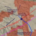
Here is something of interest I found on Mahood's blog. In this pic the entrance to Smith Water canyon is in the lower left corner. Where the dark blue meets at the right of the pic is where their car would be.


"JT80 GPS tracks are shown in dark blue. Tracks from the original search are shown in black and searches since then are shown in red. The light blue line is the 10.6 mile radius from the Serin Drive cell tower. The areas with line of sight coverage from the Serin cell tower are shaded red."


Mahood JT Smith Water canyon cell Map.jpg


http://www.otherhand.org/home-page/search-and-rescue/searching-for-bill-ewasko/jt80-1252016/

JT81-cell-areas-600x600.jpg

http://www.otherhand.org/home-page/search-and-rescue/searching-for-bill-ewasko/jt81-2042016/

It should be noted that we can't (yet) pinpoint exact cell reception as shown on this map.
 
  • #528
I'm beginning to haze over from studying the maps and all the colors. Question- where SAR believes there was a circle track.. where is that? Cell phone I believe was only in park and could not be pinpointed to any general area... correct? Human behavior habits will turn right till there is no more right turns, then backtrack to last intersection and then take other roads is very common. I'm trying to figure out from this map where the circular pattern was... and ping general location which more than likely was after the backtracking. Follow the same habits they started with and innate choices.
Apologies if this sounds confusing or nutty.


Sent from my iPhone using Tapatalk
 
  • #529
I'm beginning to haze over from studying the maps and all the colors. Question- where SAR believes there was a circle track.. where is that? Cell phone I believe was only in park and could not be pinpointed to any general area... correct? Human behavior habits will turn right till there is no more right turns, then backtrack to last intersection and then take other roads is very common. I'm trying to figure out from this map where the circular pattern was... and ping general location which more than likely was after the backtracking. Follow the same habits they started with and innate choices.
Apologies if this sounds confusing or nutty.


Sent from my iPhone using Tapatalk

They never stated that I recall where the "circling" was. As far as the road, it is the only paved portion this side of the park and the only intersection is 15-20 miles west.


Sent from my iPhone using Tapatalk
 
  • #530
The link to those SAR stories is an incredible find. Thanks again. I learned a few valuable things about how to survive being lost (in general) as I read:

1) After 2-3 days, if you don't consume water your organs start to fail, so conserve water, drink pee, and find water in dense brush areas when you can.

2) It seems like most watersheds run N/S, but most populated areas are faster reached W/E. So, always head W/E when you can using the sun's location as a compass/guide, even if the N/S route seems easier to travel.

3) If lost, move around at dawn/dusk and in moonlight if possible, and take shade during the hottest part of the day.

4) Someone will come look for you if you don't show up when you are supposed to and IF someone knows where you went. So always share your itinerary - just in case.

5) STOP walking and wait for help if someone knows where you are hiking.

6) Wile hiking around, always leave behind some sort of marking of where you have been. Make a rock cairn (stack rocks), break a branch, write words and arrows in the dirt, all or any of those. That way, if you are walking in circles you will know right away. Or if you are lost, it will help trackers find you. And marking your path with these ways does not harm the environment.
7) Always wear colorful clothing that stands out in the environment you're planning to hike in.
 
  • #531
While there's a possibility they are or were in or near this canyon, it's hard for me to grasp the concept. One reason being obvious, they would have to cross the main road. To me this would be the main objective second to getting to the car. Then you sit and wait, or follow the road. The second problem is the canyon itself. While it's not entirely remote, the initial mouth of the canyon is wide and then narrows, getting steeper as you go. It's an elevation of 1400 ft. It would be foolhardy to attempt going. At that point they would have to be completely out of their minds.

bbm

The lost Germans in Death Valley made foolhardy decisions due to a map that showed a passable road where there was none, and unfamiliarity with the terrain.

The other day I also found an article from a few years ago, titled "Death by GPS" (or similar) about a woman who had followed her car GPS into the desert because it showed a passable road (she barely survived but her small son died). I will see if I can find the article again, it was interesting. It also said that maps have since been modified for some GPS systems but I wonder whether R or J had an old map on their phone or something.

But I agree that it seems unlikely that R and J are in Smith Water Canyon because of the paved road they would have had to cross to get there.

Edit: found the article:
http://www.sacbee.com/entertainment/living/travel/article2573180.html

When you google "Death by GPS" there are quite a few articles and examples, apparently it's not very rare that people get lost following their gps.
 
  • #532
bbm

The lost Germans in Death Valley made foolhardy decisions due to a map that showed a passable road where there was none, and unfamiliarity with the terrain.

The other day I also found an article from a few years ago, titled "Death by GPS" (or similar) about a woman who had followed her car GPS into the desert because it showed a passable road (she barely survived but her small son died). I will see if I can find the article again, it was interesting. It also said that maps have since been modified for some GPS systems but I wonder whether R or J had an old map on their phone or something.

But I agree that it seems unlikely that R and J are in Smith Water Canyon because of the paved road they would have had to cross to get there.

Edit: found the article:
http://www.sacbee.com/entertainment/living/travel/article2573180.html

When you google "Death by GPS" there are quite a few articles and examples, apparently it's not very rare that people get lost following their gps.

LOL, you made me remember something I did when I was younger and more ambitious. We were out in the desert exploring any would-be dirt road. Mainly looking for mines. We had been on many side roads during our trip without incident, so I was apprehensive and eager for anything. I read about some caves that were nearby and I had a descent map. The numerous descriptions I read about the route never mentioned "high clearance vehicles" as I had read in others.

The road starting out looked pretty good but it didn't take more than a few minutes to realize it was a mistake. The road went through several washes and I had to speed up to not get stuck in the sand. The ground was intermediate, not enough to stop and turn around. We had driven about half a mile and then we were heading for a very large patch of sand. I pulled hard to the right to stay on the harder portion. We were going pretty fast for a 'dirt road', maybe 30 mph. With bushes you have rocks. This one rock, the size of bean bag, decided it was not going to let me pass. All at once we were stopped, bashed in right bumper, fender, broken axle and tire. 20 miles from any civilization. It was 113 degrees earlier but now maybe 105.

Luckily we had all our provisions with us, and since it was later in the day, we hunkered down and stayed the night. The next morning we realized we were parallel to the main road, as we could see and hear cars, about a 1/4 mile away. So we were able to get help pretty quickly and leave unscathed, with the exception of my '85 Chrysler 5th Avenue which had no business being there in the first place LOL. Lesson learned the hard way but it could have went very, very bad. For this very incident whenever I go on a trip, I tend to triple the amount of food and water I'll need. I never know what could happen, or if I get gung-ho to do something that goes the wrong way.
 
  • #533
They never stated that I recall where the "circling" was. As far as the road, it is the only paved portion this side of the park and the only intersection is 15-20 miles west.

Sorry, East not West.

I was wrong about paved roads, the road to Keys View would be the other, again many miles away.
 
  • #534
Hello everyone, I had to register to talk about this case as I have been thinking about it for the last two weeks. I live near the park entrance and am very familiar with the areas being searched. As some have already stated Smith Water canyon is not even close to Maze loop / North View area. I do not believe they would cross the main road (as well as other service roads)in that heat and not recognize it or view the situation as an emergency. Maybe they are searching areas that could have held water as requested by family members who are holding out for survival? Thats is the only reason I can think of for spending time in this area.


I do not consider the maze loop/ North View or Covington Flats area (where Ewasko went missing) very remote, even smith water canyon gets steady foot traffic. I do know that there are some slot canyons around Queen Mountain that are very rugged and hard to reach but even in these areas it would be hard to miss the valley and main road. Very strange that Orbeso&#8217;s and Ewasko&#8217;s phones &#8220;pinged&#8221; in the same area. Orbeso ending up at this location would be just as strange as Ewasko leaving it.


Little bit of local information, I was told by a search team member that it is possible the two might have been separated by the first day. I really can not understand why these two have not been found, very strange.
 
  • #535
Hello everyone, I had to register to talk about this case as I have been thinking about it for the last two weeks. I live near the park entrance and am very familiar with the areas being searched. As some have already stated Smith Water canyon is not even close to Maze loop / North View area. I do not believe they would cross the main road (as well as other service roads)in that heat and not recognize it or view the situation as an emergency. Maybe they are searching areas that could have held water as requested by family members who are holding out for survival? Thats is the only reason I can think of for spending time in this area.


I do not consider the maze loop/ North View or Covington Flats area (where Ewasko went missing) very remote, even smith water canyon gets steady foot traffic. I do know that there are some slot canyons around Queen Mountain that are very rugged and hard to reach but even in these areas it would be hard to miss the valley and main road. Very strange that Orbeso’s and Ewasko’s phones “pinged” in the same area. Orbeso ending up at this location would be just as strange as Ewasko leaving it.


Little bit of local information, I was told by a search team member that it is possible the two might have been separated by the first day. I really can not understand why these two have not been found, very strange.

Welcome, and thank you! And insight as to how/why they would have become separated or why SAR team member thought so?


Sent from my iPhone using Tapatalk
 
  • #536
Thank you.
No insight. It was this persons opinion that because of the lack of footprints and their direction/location that one of the two was disabled early on. The phone ping might back this up.
 
  • #537
About crossing the paved road to get to a different canyon... we are assuming many things. First, possibly they did initially hike in a northerly direction. Who's to say though, that they didn't feel confident so opt to also hike a second trail later in the day, and THAT'S when things went sideways.

They could have refreshed at the car, then ventured southerly for a quick hike before leaving the park, but then got lost on the return. It would not surprise me if they were located in a place absolutely no where near where SAR had initially searched, and very very far.
 
  • #538
So we know they entered the park at 6:45 am on Thursday morning. Around 4:00 pm that same day, JOs phone pinged within cell tower range of the car.

More and more, I'm starting to really think they were back at the car at 4:00 pm, and went out for a second hike since it doesn't a get dark until 8-9 pm.

Is there an updated search map? I wonder if T Manhood and his SAR friends will become involved...
 
  • #539
So we know they entered the park at 6:45 am on Thursday morning. Around 4:00 pm that same day, JOs phone pinged within cell tower range of the car.

More and more, I'm starting to really think they were back at the car at 4:00 pm, and went out for a second hike since it doesn't a get dark until 8-9 pm.

Is there an updated search map? I wonder if T Manhood and his SAR friends will become involved...

Could be. We really don't know what they're plans were or how much food and water they had. But this would make make for a very long day of hiking in the heat.

Given the trajectory of the 10.6 mile radius of the cell tower, it seems the North Trail which connects to the Maze Trail might fall in this range as well.


Sent from my iPhone using Tapatalk
 
  • #540
Could be. We really don't know what they're plans were or how much food and water they had. But this would make make for a very long day of hiking in the heat.

Given the trajectory of the 10.6 mile radius of the cell tower, it seems the North Trail which connects to the Maze Trail might fall in this range as well.
I think in one of the many blog articles about group hikes mentioned the ability to capture cell service in one teeny spot in an area overlooking Copper Mtn?

Also... http://blog.cairnme.com/post/156334143349/cell-coverage-at-joshua-tree-national-park

https://www.nps.gov/jotr/planyourvisit/goodsandservices.htm
 
Status
Not open for further replies.

Staff online

Members online

Online statistics

Members online
66
Guests online
1,755
Total visitors
1,821

Forum statistics

Threads
632,472
Messages
18,627,251
Members
243,163
Latest member
420Nana
Back
Top