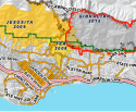
CA - Wind-Driven Thomas Fire Explodes to 31,000 Acres; 150 Structures Destroyed, 2017

  • #461
  • #462
  • #463
"An evacuation center has been established at the UC Santa Barbara Recreation Center at 516 Ocean Road.

Animal evacuation centers are available for people in evacuation zones. Those wishing to coordinate sheltering for both small and large animals should call the Santa Barbara County Animal Services hotline at (805) 681-4332."

https://www.nbclosangeles.com/news/...o-Acres-Threatening-Structures-464766303.html
 
  • #464
"Current mandatory evacuations are in place for the following areas:

All areas east of Highway 154

All areas south of east Camino Cielo Road

All areas west of Toro Canyon Road

All areas north of the 101 Freeway at Toro Canyon Road to south Salinas Street, then north of Alameda Padre Serra to Highway 192 and west to Highway 154.

Area east of Toro Canyon Road to Casitas Pass Road north of Highway 192 and south of east Camino Cielo Road."

Thomas Fire Grows to 269K Acres, Threatening 18K Structures
https://www.nbclosangeles.com/news/...o-Acres-Threatening-Structures-464766303.html
 
  • #465
Couple loses two homes in two months to California wildfires
http://www.cnn.com/2017/12/12/us/couple-loses-two-homes-california-wildfires/index.html

"Now, both homes are gone. They were lost to raging wildfires within two months of each other.

In October, the Tubbs Fire destroyed their Santa Rosa home. Last week, the*Thomas Fire*torched their Ventura home.

"It was pretty devastating. It didn't seem like I could lose two houses in two separate fires only two months apart," Antonio Wong said."
 
  • #466
  • #467
"Nearly 9,000 firefighters

About 8,400 firefighters are tackling the Thomas Fire alone.

The Nevada Department of Corrections and Nevada Division of Forestry, which run conservation camps, have sent six trained crews of minimum security inmates to help.

Thousands more firefighters -- including from Arizona, Colorado, Idaho, Oregon, Utah and Washington state -- have been involved in battling the other wildfires."

http://www.cnn.com/2017/12/11/us/california-wildfires-numbers/index.html

(Wasn't there one inmate who escaped while fighting the NorCal fires? Maybe I dreamed this, I don't think so though...)
 
  • #468
  • #469
  • #470
  • #471
  • #472
Couple loses two homes in two months to California wildfires
http://www.cnn.com/2017/12/12/us/couple-loses-two-homes-california-wildfires/index.html

"Now, both homes are gone. They were lost to raging wildfires within two months of each other.

In October, the Tubbs Fire destroyed their Santa Rosa home. Last week, the*Thomas Fire*torched their Ventura home.

"It was pretty devastating. It didn't seem like I could lose two houses in two separate fires only two months apart," Antonio Wong said."

OMG. Double the devastation. :(
 
  • #473
Winds Ease In Santa Barbara As Firefighters Enter Day 14 Of Thomas*Fire
http://losangeles.cbslocal.com/2017/12/17/thomas-fire-santa-barbara-2/

"After winds roared at around 30 mph (48 kph), with gusts to about 60 mph (97 kph) on Saturday, they eased Sunday with gusts of up to 35 mph (56 kph). A Red Flag warning was lifted early Sunday for the area.

But even the lower intensity winds are still extremely dangerous, said fire spokesman Jude Olivas."
 
  • #474
Thomas Fire now third-largest wildfire in modern California history
http://www.cnn.com/2017/12/16/us/california-fires/index.html

"Thousands of additional residents were evacuated Saturday from areas near the Thomas Fire, now the third-largest wildfire in modern California history.

Fueled by high winds, the massive fire north of Ventura continued growing Saturday. It had burned 267,500 acres by Saturday evening, Cal Fire said. That's up from 256,000 acres on Friday."
Just how big is an acre? Well, 1 acre = 0.0015625 square miles. So:

Thomas Fire (Ventura County, Santa Barbara County): 267,500 acres = 417.96875 square miles

Lilac Fire (San Diego County): 4100 acres = 6.40625 square miles

e010.gif
<<<--me, trying to get my mind around this thing.
 
  • #475
  • #476
  • #477
Last night it was said on the livestream Spellz posted upthread that it wasn't far from becoming the second largest fire, not sure exactly of the number, but I think if it surpassed 290,000 or so. Awesome to listen to right now, too, as it is on going, so not posting specifics from it (seems like it would qualify as basement type info), but taking notes as it progresses.

Sunday Bilingual Update - City of Santa Barbara Update on Thomas Fire
https://www.youtube.com/watch?v=RzW5TNabfVY


Yes! I agree! The same appreciation goes to you, too, Find HG. Who needs the news with you two on the job?!
a085.gif
Thank you!

How this could be a pleasure to do is hard to understand and easy, you're my friends.

You're very welcome, coastal. Magz sets the paths, I follow.

It is completely an honor and so enriching to share this here with you all.

I hope IQ is okay and I wish I could fly her here for the holidays at least, at this point. Hoping for safety for all.
 
  • #478
Just how big is an acre? Well, 1 acre = 0.0015625 square miles. So:

Thomas Fire (Ventura County, Santa Barbara County): 267,500 acres = 417.96875 square miles

Lilac Fire (San Diego County): 4100 acres = 6.40625 square miles

e010.gif
<<<--me, trying to get my mind around this thing.

It's a monster!
 
  • #479
"Dawn&#8217;s early light brought a welcome sight to South Coast residents and firefighters alike on Sunday, as the massive Thomas Fire had visibly calmed overnight.

In contrast to the previous day, when gusty downslope winds whipped the blaze into an inferno, sending a giant pall of smoke over the South Coast, Sunday morning found relatively small columns of smoke rising from the 2-week-old fire, which has grown to 269,000 acres and remained at 40-percent contained.

&#8220;I&#8217;m doing a hell of a lot better than I was doing yesterday morning,&#8221; Santa Barbara County Fire Chief Eric Peterson told Noozhawk at mid morning."


https://www.noozhawk.com/article/with_improved_weather_firefighters_go_on_attaack_thomas_fire

Erm

http://abc7.com/thomas-fire-grows-to-420-square-miles/2791542/

~


http://www.kcra.com/article/were-en...ws-share-experience-from-thomas-fire/14448486

"Images from Sacramento region fire crews continue to emerge from the front lines of the Thomas Fire. Together they're part of an unprecedented response to the raging flames.

"The Western United States is fighting this fire. We currently have 8,370 firefighters and support personnel working this incident which is the largest cadre of personnel on any fire in California state history,"...
...
"We're engaged in battle," said Rubinstein. "I haven't seen anything of this size. This is a very very challenging fire with a lot of damage and a lot of destruction,"...


~

http://www.ocregister.com/2017/12/1...y-because-of-strong-winds-and-dry-conditions/

"Gusts of wind reaching up to 55 miles per hour are expected across Southern California through Sunday night, prompting the National Weather Service to issue fire danger warnings.

The strongest winds are expected below the Cajon Pass in San Bernardino County and in the coastal foothills of the Santa Ana mountains, said National Weather Service meteorologist Derek Schroeter.

Early Sunday gusts of 63 miles per hour were recorded at Freemont Canyon north of Irvine Lake while 58 mile per hour gusts were recorded at Pleasants Peak in Limestone Canyon Regional Park.

The fire danger warning remains in effect until 8 p.m. Sunday, Dec. 17."


~
https://www.independent.com/news/2017/dec/17/heres-exactly-how-far-thomas-fire-has-eaten-montec/

Screen Shot 2017-12-17 at 2.59.16 PM.png

"Saturday evening&#8217;s map, seen above, reveals the Thomas Fire&#8217;s western flank has swelled to reach Gibraltar Road and Rattlesnake Canyon Park. Despite reports Saturday, it does not appear to have entered Parma Park. The fire&#8217;s southern edge now runs along East Mountain Drive and Park Lane in Montecito. To the north, it&#8217;s skirting the edge of East Camino Cielo.

View the high-resolution version of this Cal Fire map and others, which allow users to zoom in and search locations in greater detail, by visiting..."
[ https://inciweb.nwcg.gov/incident/maps/5670/ ]
 
  • #480
Funeral procession begins for fallen local firefighter
CBS 8 LA

Updated: Dec 17, 2017 1:59 PM EST


A five-county funeral procession began at 10 a.m. Sunday for a San Diego firefighter...
...
Cory Iverson, 32, was a fire engineer for Cal Fire San Diego. He was killed Thursday near Fillmore, falling victim to thermal injuries and smoke inhalation, according to autopsy results released Saturday by the Ventura County Medical Examiner's Office.

The procession in his honor began at the Ventura County Medical Center and is scheduled to travel through the Los Angeles area before stopping at a temporary staging point in Chino around noon, according to Cal Fire. It will continue from there down the Interstate 15 corridor before concluding at a Miramar mortuary just after 2 p.m.
...

_____
"LIVE STREAM: News 8 will stream the procession's conclusion around 1:20 p.m. Sunday both online and on Facebook."

http://www.cbs8.com/story/10363609/cbs-news-live-stream

https://www.nbcsandiego.com/news/lo...om-Ventura-County-to-San-Diego-464690853.html

http://www.keyt.com/news/live-wall-to-wall-coverage-of-the-thomas-fire-continues/670698437
 

Members online

Online statistics

Members online
138
Guests online
2,557
Total visitors
2,695

Forum statistics

Threads
632,815
Messages
18,632,100
Members
243,303
Latest member
Corgimomma
Back
Top