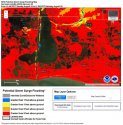
From FLHurricane Facebook post.
Flhurricane.com
Hurricane Laura has new Warning issued:
A Storm Surge Warning is in effect from San Luis Pass Texas to the Mouth of the Mississippi River, including areas inside the Port Arthur Hurricane Flood Protection system.
A Hurricane Warning is in effect from San Luis Pass Texas to Intracoastal City Louisiana.
A Tropical Storm Warning is in effect from Sargent Texas to San Luis Pass and from east of Intracoastal City to the Mouth of the Mississippi River.
A Storm Surge Watch is in effect from Freeport Texas to San Luis Pass.
Those in the warning area need to prepare for a major hurricane, if you live an evacuation area please consider doing so. Check local media and officials for more information for your local area.
A Storm Surge Warning is in effect from San Luis Pass Texas to the Mouth of the Mississippi River, including areas inside the Port Arthur Hurricane Flood Protection system.
A Hurricane Warning is in effect from San Luis Pass Texas to Intracoastal City Louisiana.
A Tropical Storm Warning is in effect from Sargent Texas to San Luis Pass and from east of Intracoastal City to the Mouth of the Mississippi River.
Recon is finding the hurricane gaining strength this morning and it expected to become a major hurricane tomorrow before landfall overnight Wednesday into Thursday,
Key Messages:
1. Laura is forecast to reach the northwestern Gulf Coast at or
near major hurricane intensity Wednesday night. Do not focus on the
details of the official forecast given the typical uncertainty in
NHC's track and intensity predictions. Storm surge, wind, and
rainfall hazards will extend well away from Laura's center along the
Gulf Coast.
2. There is the danger of life-threatening storm surge accompanied
by large and dangerous waves from San Luis Pass, Texas, to the Mouth
of the Mississippi River, including areas inside the Port Arthur
Hurricane Flood Protection system. A Storm Surge Warning is in
effect and residents should follow any advice given by local
officials. Actions to protect life and property should be rushed to
completion today, as water levels will begin to rise Wednesday.
3. Hurricane conditions are expected by Wednesday evening in the
area from San Luis Pass, Texas, to west of Morgan City, Louisiana,
and a Hurricane Warning is in effect. Tropical storm conditions are
expected to begin in the warning area Wednesday afternoon.
4. The threat of widespread flash and urban flooding along with
small streams overflowing their banks will be increasing Wednesday
night into Thursday from far eastern Texas, across Louisiana, and
Arkansas. This will also lead to minor to isolated moderate river
flooding. The heavy rainfall threat will spread northeastward into
the middle-Mississippi, lower Ohio, and Tennessee Valleys Friday and
Saturday.
STORM SURGE: The combination of a dangerous storm surge and the
tide will cause normally dry areas near the coast to be flooded by
rising waters moving inland from the shoreline. The water could
reach the following heights above ground somewhere in the indicated
areas if the peak surge occurs at the time of high tide...
Sea Rim State Park TX to Intracoastal City LA including Sabine Lake
and Calcasieu Lake...9-13 ft
Intracoastal City to Morgan City including Vermilion Bay...7-11 ft
Port Bolivar TX to Sea Rim State Park...6-9 ft
Morgan City LA to Mouth of the Mississippi River...4-6 ft
San Luis Pass TX to Port Bolivar...3-5 ft
Galveston Bay...3-5 ft
Freeport TX to San Luis Pass...2-4 ft
Mouth of the Mississippi River to Ocean Springs MS including Lake
Borgne...3-5 ft
Lake Pontchartrain and Lake Maurepas...2-4 ft
The deepest water will occur along the immediate coast near and to
the right of the landfall location, where the surge will be
accompanied by large and destructive waves. Surge-related
flooding depends on the relative timing of the surge and the tidal
cycle, and can vary greatly over short distances. For information
specific to your area, please see products issued by your local
National Weather Service forecast office.
RAINFALL: Laura is expected to produce the following storm total
rainfall accumulations:
Western Cuba...Additional totals of 1 inch or less.
United States...From Wednesday night into Saturday, Laura is
expected to produce rainfall of 4 to 8 inches, with isolated maximum
amounts of 12 inches across portions of the west-central U.S. Gulf
Coast from western Louisiana into east Texas, and northward into
portions of the lower to middle Mississippi Valley, lower Ohio
Valley, and Tennessee Valley. This rainfall will cause widespread
flash and urban flooding, small streams to overflow their banks, and
minor to isolated moderate river flooding.
WIND: Hurricane conditions are expected in the hurricane warning
area Wednesday night and Thursday. Tropical Storm conditions are
expected to reach the coast in the hurricane warning area late
Wednesday or Wednesday night, and are expected in the tropical
storm warning area Wednesday night and Thursday.
SURF: Swells generated by Laura are affecting portions of Cuba, the
central Bahamas, and the Florida Keys. Swells are expected to spread
northward along portions of the west coast of Florida peninsula and
the coast of the Florida panhandle later today and tonight, and
reach the northern and northwest Gulf coast by Wednesday. These
swells are likely to cause life-threatening surf and rip current
conditions. Please consult products from your local weather office.


