- Joined
- Feb 11, 2023
- Messages
- 1,353
- Reaction score
- 13,191
Pattie had twice hiked the Camino de Santiago in Spain, and part of the Shikoku trail in Japan.
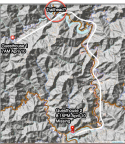
The Camino de Santiago is a walk in the park (albeit a long one) in comparison to the Kohechi trail. The Kohechi trail is 'a totally different league' according to someone who walked both. (I read this on a camino forum.)
IMO Patrtie could be overdoing it.
I've had a thought, but I don't want to cast any aspersions on Pattie's honesty.
To prove you have completed your pilgrimage you have to collect stamps along the trail. Most sections of the trail have the stamps located on the trail. You can't cheat. If you don't walk the trail you can't get the stamp.
But the Miura-toge Pass doesn't appear to have stamps to collect on the trail; you collect your stamp after you reach Totsukawa Onsen. That means you could collect a stamp to say you walked the trail even if you didn't.
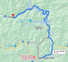
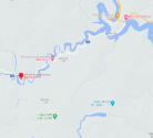
The image I posted earlier showing where you leave Route 733 towards the trailhead (Link) is also a BUS STOP. I've been looking for the bus schedule but so far haven't been able to find it.
What if Pattie was never planning to walk the trail that day, and something instead happened when she was trying to use public transport or hitchhike?