The 10th anniversary of the discovery of this *still* unidentified individual has just passed. I live in central Maine and remember hearing about it when he was first discovered. I know this thread is old and dormant but I wanted to post a few thoughts and resources in case anyone is still paying attention.
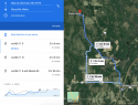
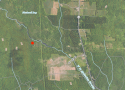
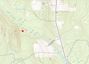
The NamUs GPS coordinates for the UID are indeed about a mile west of ME-11 as noted in some of the reporting. ME-11 here is the eastern boundary of a big working forest that stretches about 9 miles west to the East Branch of the Penobscot and Sebois Rivers, another natural boundary to anyone on foot (Lunksoos Camp on the East Branch is where Donn Fendler’s famous journey concluded). Happy Corner Road is another boundary just under 2 miles north of UID’s location. The entire expanse of forest is carved up by logging roads and ATV trails. To get a sense of how the UID could have entered the area, I tried mapping out the major trail intersections along ME-11 and Happy Corner that were not obviously driveways to homes or farms. I can’t say that this mapping effort led me to any great conclusions. It seems likely that UID entered the woods somewhere off of ME-11, perhaps as far south as the powerline at Stacyville or the Katahdin High School campus. There is a footbridge across the West Branch Molunkus Stream at the school. He was eventually found just to the west of a branch of this stream further north. There are a couple logging/farm road bridges that could have put him west of the stream, too.
He could have come from the north and the Patten area but it just seems so much more likely he’d have come from the I-95 interchange area in Sherman, five miles as the crow flies from his final location. I do notice that there is a scenic outlook pull-off just 1.25 miles from his location that could also have been a drop-off point (it was also there in 2010).
Reporting states that the UID had been there for the “past two months,” and “since September,” and then, later, that he had died “months before.” The PMI recorded in NamUs, however, is a (oddly?) precise 26 days. If that is accurate, it puts UID’s death around Saturday, October 9, 2010.
This makes more sense to me given the clothing described. I looked up the temperature and precipitation history from the NOAA station in Millinocket for September 2010 - November 4, 2010 (attached PDF). September that year came in blistering hot with high temps topping 90 degree F the first four days of the month. Only two lows that month dipped below 40 degrees F (9/18 & 9/19). October brought lows in the upper 20s and lower 30s and highs mostly below 60 F. UID’s clothing indicates at least some sort of layering system: long sleeve shirt base layer, sweater in bag, worn coat, knit hat. This and the contents of the bag, hydration and insect repellent, feel to me like obvious choices for a brief casual day hike made by a somewhat inexperienced individual, perhaps expecting to be out during the early and/or late part of the day when temps swing.
The advanced state of decomposition described, though, sure seems to my uneducated understanding of these things to be longer than 26 days. No hands? Ok, animal activity maybe? The pictures of his clothes on NamUs show everything totally soaked like he was found in standing water and his location as documented in NamUs sure seems like a boggy/swampy area. Does that speed up decomposition?
A few unorganized thoughts:
- The Vineyard Vines outlet in Freeport, Maine didn’t open until the summer of 2011
- The Vineyard Vines brand was only about 12 years old in 2010
- The only people I observe wearing Vineyard Vines shirts in central Maine in 2020 are preppy young college guys
- This individual was not dressed like a local. As others have noted, maybe he was dressed like someone from southern Maine, a summer (summah!) person, or someone else from away.
- St. John’s Bay clothing is indeed the store brand of JCPenny
- JCP sells High Sierra brand luggage (at least in 2020)
- JCP sells New Balance shoes (at least in 2020)
- New Balance shoes “made in the USA,” like the UID’s, are made in five facilities in Maine and Massachusetts (at least in 2020)
- There is a New Balance factory store in Skowhegan, Maine and it existed in 2010
- Blue & white (like UID’s knit cap) high school athletics colors in the area (may be others):
- There is a motel and convenience store right near the I-95 interchange in Sherman and both appear to have been there in 2010