GUILTY NH - AH, 14, North Conway, 9 October 2013 - # 1

Status
Not open for further replies.
  • #641
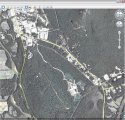
At the base of eagle way, she would turn right on Eastman Rd .cross Eastman somewhere and head up on dirt road beside a tall stockade fence. This is behind Walmart. There is a dirt road beside a stockade fence.

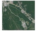
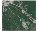
Danak would know this, geez, can you enlarge that part of the map, geevee?
I am too stupid to do maps.

Is this the right area?

EaglesWay2_zps5aa2754f.jpg
 
  • #642
Is this the right area?

EaglesWay2_zps5aa2754f.jpg

Yes, the dirt path ohoh is referring to is just above the "d" in "Eastman Rd". But this doesn't line up with..."I was walking behind her and I was going down Eagles Way and she turned off onto a dirt road on the right hand side," DF, Abby`s friend said, IMO.
 
  • #643
Is this the right area?

EaglesWay2_zps5aa2754f.jpg

Being from NH I can tell you especially up near the mountains, those pine tree forests are thick. I think the most recent aerial photo that we keep accessing on Google maps doesn't show a whole lot of foot paths through the woods off Eagle's Way. I looked on Google Earth and looked at the aerial photo from 2011, and it looks like you can see more paths in the woods. The best I could do is a screen shot...
 

Attachments

  • Eagle's Way 2011 aerial photo.jpg
    Eagle's Way 2011 aerial photo.jpg
    161.9 KB · Views: 48
  • #644
Is this the WalMart?

EaglesWay3_zps88ffe2eb.jpg
 
  • #645
  • #646
And here's a view of a 2009 aerial of Eagle's Way.
 

Attachments

  • Eagle's Way 2009 Aerial Photo.jpg
    Eagle's Way 2009 Aerial Photo.jpg
    153.1 KB · Views: 59
  • #647
These kids walked these distances daily?
 
  • #648
Oh, am sorry, company just left, I do not see the dirt rd there, go back up near Redstone area. I see that fence , dirt rd. From the car as we drive past on Eastman rd.

The friend would sure have to be standing a long time at eagles rd. To see her walk that far. Am wondering about that ?????????

Do not know for sure, but thought the wooded path from school had an exit over near Redstone.
 
  • #649
And here's a view of a 2009 aerial of Eagle's Way.

Perfect map, as you would be walking down eagle way you can see a wooded path kids might take.

That path would Exit on Eastman,I see a retention pond way far back from Walmart , that is where the stockade fence and dirt road is.
 
  • #650
Perfect map, as you would be walking down eagle way you can see a wooded path kids might take.

That path would Exit on Eastman,I see a retention pond way far back from Walmart , that is where the stockade fence and dirt road is.

Forgive my crude drawing using Adobe, but this is the footpath that I see that could be a short cut. Is this what you're thinking too?
 

Attachments

  • Foot Path Eagle's Way to Eastman Rd.jpg
    Foot Path Eagle's Way to Eastman Rd.jpg
    158.3 KB · Views: 101
  • #651
Oh YES, that is it.
 
  • #652
Any children who are friends of Abigail must be referred to with their initials only. You may not sleuth minor children at all!
 
  • #653
So, the dirt road goes nowhere but beside that retention pond. You can not even see there is water there, from Eastman Rd. No reason for any kids to be there. Hope I can say this, but if a kid saw AH take that wooded path they would not be able to see any dirt road off Eastman rd- while they were on the school rd, eagles way.
 
  • #654
Hey guys I read on a msm article somewhere that the secret service is assisting in this investigation I haven't ever seen them assist any idea why?? Thanks
 
  • #655
Hey guys I read on a msm article somewhere that the secret service is assisting in this investigation I haven't ever seen them assist any idea why?? Thanks

In the Jessica Heeringa case, the Secret Service came in to review video.
 
  • #656
I somehow skipped a page in the thread with a link to why the secret service is involved in missing children cases but now I know thanks!
 
  • #657
No idea about the SS, but a lot of FBI, it says so on the back of their jackets. They were at roadblocks, saw that in photos.

Moo - they are in control re any news that oozes out.
 
  • #658
  • #659
Okay, I am only on page 15, so no idea, if someone was able to create a map yet. Plumeria messaged me this weekend requesting my help, but unfortunately, I am rarely on a computer on the weekend anymore.

Here's what I have so far (no idea if this will work, as I am trying Bing Maps for the 1st time, as the map of this area is much clearer on Bing than Google)...

http://www.bing.com/maps/?v=2&cp=44...=0&sty=h&cid=49B0E16AAA81621D!113&form=LMLTSN
 
  • #660
Just stopping in for lunch , many LE in dress clothes around the bridge over the saco just south of the police station... Heading back through there now..
 
Status
Not open for further replies.

Members online

Online statistics

Members online
64
Guests online
1,263
Total visitors
1,327

Forum statistics

Threads
632,335
Messages
18,624,886
Members
243,095
Latest member
Lillyflowerxx
Back
Top