My apologies. Apparently I’d come across a previous address (jmo). Using an address in Lynchburg, my guess is that (assuming TLB was headed home) he would’ve taken Hwy 76 (Florence Hwy) from E. Sumter toward/through Mayesville toward/through Atkins to Lynchburg (Magnolia St - which I now think is a correct address, but jmo).
Imo (and from personal experience), it takes a few miles of straightaway at speed before one nods off. If this is what happened - and if it happened on a straightaway - I think TLB’s car would have been discovered by now.
So, if a single car accident occurred, I think there had to have been enough of a curve (still at speed) for the car to have travelled far enough off the hwy that it could not be easily seen. From google earth, there are no lakes that I can find along Florence Hwy, but there are several stretches of heavily wooded areas where there are no houses.
The first curve going N on Hwy 76 is approaching and just past Linran Lane. Imo this is an unlikely location as not enough time to have nodded off. The next curve, while not sharp, is at Rocky Bluff Swamp (on the left). This one I think is higher probably.
The one after that (just past Beulah Church) I think is lower probably as it is close to the church.
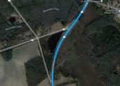
The next significant curve is one that I think, like the one at the swamp, has higher probability: it is on the left side of Hwy 76 just after you cross 46 (Bell Road).
Two final possibilities (less likely though as the curves are not sharp, and they occur too far along the route - if TLB nodded off I think it would’ve happened earlier): on the right side of road in Mayesville just past Avenue A, and then again on the right as you approach Lynchburg.
I don’t know that a single vehicle accident occurred, but I think it is certainly a possibility. I hope TLB can be found soon for his family.
All jmo