VA VA - Kelly Catalano, 40, Chesterfield, 15 Jan 2010 - #2

Status
Not open for further replies.
  • #101
I don't live in Virginia and I'm not really familiar with the Richmond area. But for those that do live in that area, has any of the following been considered?

From either where Kelly worked at her place of employment or from where Kelly lived at her home, are there any other body of waters within 30 minutes of either location?

I'm thinking about lakes, ponds, and reserviors on public property that have public access.

What about parks within 30 minutes of either location? Are there any parks that have trails, such as bike, hiking, or walking trails? Are there any hills or ravines in the area?

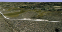
She went missing from the Colonial Heights area, rght? Swift Creek and the reservoir are right down the road a few miles. There is also Swift Creek that has a back access behind a rather high-end restaurant where some people go to "wet a line". That's fishing for you rookies. :) The creek winds back into nowwhere.

There's also a road that cuts off of the bridge going over into Petersburg. You would need a 4-wheel drive to get down in there, but it's a lovely, quiet secluded spot on the river. Another good fishing spot. (Sorry. After all this snow I am longing for a lounge chair, a good book and sitting in the sun while hubby fishes.)

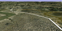
Henricus Park is further away, but there are trails and more water.

I guess my point is, even though the area is populated, there are lots of secluded areas. The thought is overwhelming.
 
  • #102
I guess my point is, even though the area is populated, there are lots of secluded areas. The thought is overwhelming.

Ok, it is my understanding that there are marshes in the area, especially at the Point of Rocks Park. Now are the marshes like quicksand? I believe one of the posters stated that if one were to sink in the marshes, they would never be found.

What about swamps? Are there any swamps in the area?

Are there any wildlife that one would have to be concerned about if they were walking in a secluded area?
 
  • #103
Ok, it is my understanding that there are marshes in the area, especially at the Point of Rocks Park. Now are the marshes like quicksand? I believe one of the posters stated that if one were to sink in the marshes, they would never be found.

What about swamps? Are there any swamps in the area?

Are there any wildlife that one would have to be concerned about if they were walking in a secluded area?

I've been to Point of Rocks many times. We were either there for sporting events or family picnics. I've never even seen water there. There is a lot of wooded area and ravines.

There are swampy spots all around the area. Prince George springs to mind because there is a lot of farm land and ponds. A lot of ponds are on private property and some of those are hard to get to. We go fishing (there I go again) on private property in Prince George that has an "honor box". You throw a few bucks in it and continue down a rutted out trail to the most back woods spot you could ever imagine.

Do you get what I'm saying? This is only one pond out of many. This is a HUGE area.

The normal person stays on dry land instead of treading through swampy, snaky areas. Or maybe that's just me. :) Plus the mosquitos will eat you alive around that kind of water during the summer. Never ventured near it during cold months.

Not sure about quicksand, but once while out on the river during low tide, I felt the need to get out of the boat. :innocent: I sank up to my knees in this black mucky stuff. I was surprised and spooked because it looked so firm.

Once in a GREAT while there is a bear sighting. My bet is a human predator.

Sorry I am not the sleuth you were looking for.
 
  • #104
...I was looking at one of the photos that you posted of BPA and the river that's next to BPA. Looking at the photos, I see that there are islands in the river.

What areas along the river has been searched?

Did they just only search along the side of the river?

Have the islands along the river been searched as well?

In another thread I was talking about hand held GPS devices. I believe cell phones have GPS. If I'm correct, I also believe the GPS on the cell phones can be used the same way as one would use a GPS on a car dashboard or handheld unit walking in a field. So if Kelly's cellphone had GPS, it is possible that it could store waypoints and tracks.


[Bolded by me.] Great questions about the search. I hope joseph d. will stop by to answer them for you--he's the source of our search information and has been doing an incredible job in trying to find Kelly.

As for GPS, I love the idea that, if her cell phone could be found, stored waypoints and tracks could be examined. That in fact would be amazing! But I believe wherever Kelly is, there also is her cell phone. And unfortunately until LE/searchers find her, we will not be privy to such intricate details of where she was when. What a shame! Is there another way to gather that information? Cell towers? Pings? Any of that? (I'm cell-phone-technology stupid.)

Thanks, Nerosleuth
 
  • #105
the whole river in her area has been searched. that includes the islands, tributaries, marsh, you name it. nothing. i will conduct yet another search at the rock park soon. if anyone is willing to help i need it, let me know.:woohoo:
 
  • #106
Ok, it is my understanding that there are marshes in the area, especially at the Point of Rocks Park. Now are the marshes like quicksand? I believe one of the posters stated that if one were to sink in the marshes, they would never be found.

What about swamps? Are there any swamps in the area?

Are there any wildlife that one would have to be concerned about if they were walking in a secluded area?

Maybe I have misled people with my choice of words, the difference between marsh and swamp....Nero, the "islands' that you see in the river are just high weeds where many duck hunters hide in their boats (joseph, correct me if i am wrong) but i dont believe anyone could walk or stand on them, but I maybe wrong.

Between BPA and PRP is more what we would call swamp I guess. I personally have never known anyone to go in there as it looks very daunting to even walk. Even a hard rainfall will cover snake road or Ruffin Mill Road if you prefer the proper name, the whole area floods in a hurry from the river side of the road.

Hope this helps more than confuses. If I was taking off from BPA I'd go the other way that we all seem to be looking, I'd head for I-95, maybe a few hundred yards thru the fields behind the linen factory or Route 301, maybe a mile at best. That is if i was just getting away on my own. JMO
 
  • #107
not true. the islands at low tide can be walked through with no problem. yes the high weeds is what we look for to hide in but at the base of those weeds is enormous and seem to interlock together somehow making it easy to walk through. but cannot be done at low tide at all. now swamps are a different story. the beavers make em and can make deep holes. last year i fell in one that was at least 10 ft deep, then about 2 steps away was only inches. it can get dangerous.
 
  • #108
ok just talked to my friend "aka scrappy" and we will be conducting a search at the park this saturday at 12:00 pm. alot of people have contacted me with when we were gonna do this. well now we are, and in need of people to help us. please reply with your name and how many people will be in the party. we appreciate all your help. dress warm, there is still snow everywhere. we will have one atv. if you have hand held cb's that would be great also. lets go people..........:angel:
 
  • #109
I'm too far away to go, but best of luck to everybody with the search, and prayers for answers for Kelly...
 
  • #110
Offering my deepest thanks and prayers to Joseph d and all searchers. Wish I could be there personally but I'm on the East Coast.
 
  • #111
Joseph, I should be able to help with the search. It will just be me (and dog if you think that's helpful - she's not trained or anything)
-Clarissa

P.S. please let me know where exactly to meet. thx
 
  • #112
will give the meeting info in the morning.
 
  • #113
Hi fellow sleuths,

I'm attaching images of the boardwalks at Point of Rocks Park.

I had no idea what they looked like from overhead (thanks to satellite imaging, we can see that), and the boardwalks truly do wander and wind through extremely marshy conditions, right to the edge of the Appomattox.

They are certainly worth a look-see.
 

Attachments

  • boardwalk at PRP #1.gif
    boardwalk at PRP #1.gif
    354.1 KB · Views: 21
  • boardwalk at PRP #2.gif
    boardwalk at PRP #2.gif
    343.3 KB · Views: 17
  • boardwalk at PRP #3.gif
    boardwalk at PRP #3.gif
    377.4 KB · Views: 16
  • overhead of  boardwalk.gif
    overhead of boardwalk.gif
    376.6 KB · Views: 12
  • #114
that area has been searched already. sorry to say. i will still do another search saturday if people reply back.
 
  • #115
off topic

iiiiiiiiiiiiiiiiiiiiiiiiiiiiiiiiiiiiii HAPPY BIRTHDAY KNOWTHINGS iiiiiiiiiiiiiiiiiiiiiiiiiiiiiiiiii

appreciate you!
 
  • #116
that area has been searched already. sorry to say. i will still do another search saturday if people reply back.

well not the whole area i beleive. the bridge area and whatnot i dont think was ever searched, but the river area and all around was
 
  • #117
My bet is a human predator.
Sorry I am not the sleuth you were looking for.

Marine Mom, you did an excellent job describing describing the topographical features of the land in your area. The information you gave is valuable. I agree with you that we're dealing with a human predator rather than a wildlife predator.

Is there another way to gather that information? Cell towers? Pings? Any of that?

Truthsleuth, If her cell phone wasn't turned off, or her cell phone battery ran out of charge or taken out of the cell phone by someone, I believe info about the last pings and cell towers could give LE a general idea about her last whereabouts.

Now this is a big if here. If Kelly had a hand held GPS unit and a pc in her home, it is possible that she could have a GPS software program on her pc.

The software program from the GPS manufacturer can be street maps or topographical maps that she can download from her pc on to her GPS unit. She could have also stored waypoint locations on her pc of places that she have been to.
 
  • #118
nerosleuth said:
Truthsleuth, If her cell phone wasn't turned off, or her cell phone battery ran out of charge or taken out of the cell phone by someone, I believe info about the last pings and cell towers could give LE a general idea about her last whereabouts.

Now this is a big if here. If Kelly had a hand held GPS unit and a pc in her home, it is possible that she could have a GPS software program on her pc.

The software program from the GPS manufacturer can be street maps or topographical maps that she can download from her pc on to her GPS unit. She could have also stored waypoint locations on her pc of places that she have been to.

Kelly did have a pc in her home. So the question remains, did she have a handheld GPS unit? If any family members are still reading here, do you know the answer to that question? TIA!

Thanks nerosleuth!
 
  • #119
Joseph d,

Thank you for taking the time to search for Kelly. To you and all the searchers that can participate, please be careful and be safe searching for Kelly this weekend.

I live too far away to assist you in the search, but I will be with you in spirit.
 
  • #120
Am I going nuts ? Wasnt there a post that is not there anymore?
 
Status
Not open for further replies.

Staff online

Members online

Online statistics

Members online
107
Guests online
1,267
Total visitors
1,374

Forum statistics

Threads
632,359
Messages
18,625,287
Members
243,111
Latest member
ParalegalEagle13
Back
Top