2024 Hurricane and Tropical Weather

DNA Solves
DNA Solves
DNA Solves
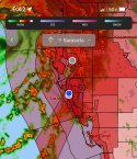
...TROPICAL DEPRESSION FORMS OFF THE SOUTH COAST OF CUBA... ...EXPECTED TO BECOME A TROPICAL STORM OVER THE SOUTHEASTERN GULF OF MEXICO BY LATE SATURDAY...

11:00 PM EDT Fri Aug 2
Location: 21.4°N 79.7°W
Moving: WNW at 17 mph
Min pressure: 1010 mb
Max sustained: 30 mph

INIT 03/0300Z 21.4N 79.7W 25 KT 30 MPH
12H 03/1200Z 22.6N 81.4W 30 KT 35 MPH...OVER CUBA
24H 04/0000Z 24.6N 83.3W 35 KT 40 MPH...OVER WATER
36H 04/1200Z 26.6N 84.1W 45 KT 50 MPH
48H 05/0000Z 28.4N 84.0W 55 KT 65 MPH
60H 05/1200Z 29.9N 83.4W 60 KT 70 MPH...INLAND
72H 06/0000Z 30.8N 82.5W 40 KT 45 MPH...INLAND
96H 07/0000Z 31.8N 80.9W 45 KT 50 MPH...OVER WATER
120H 08/0000Z 32.8N 79.4W 55 KT 65 MPH

Tropical Depression Four Forecast Discussion
 
We've had an outer band go thru around noon with some rain. The wind picks up and then dies back down. Nothing consistent yet. We moved the lawn / gardening items inside. It is 88 degrees, sunny and feels like 98 degrees with 69% humidity.

My oldest drove down to Sarasota from the Panama City FL this morning and only drove thru one band of rain. Nothing dramatic.


Tropical Depression FOUR
As of 18:00 UTC Aug 03, 2024:

Location: 23.3°N 82.6°W
Maximum Winds: 30 kt Gusts: N/A
Minimum Central Pressure: 1008 mb
Environmental Pressure: N/A
Radius of Circulation: N/A
Radius of Maximum wind: 120 nm

1722714591641.png
 
...DEPRESSION BECOMES TROPICAL STORM DEBBY OVER THE SOUTHEASTERN GULF OF MEXICO......HURRICANE WARNINGS ISSUED FOR PORTIONS OF THE GULF COAST OF FLORIDA...

5:00 PM EDT Sat Aug 3
Location: 23.9°N 83.2°W
Moving: NW at 15 mph
Min pressure: 1007 mb
Max sustained: 40 mph
 
FORECAST POSITIONS AND MAX WINDS

INIT 04/0300Z 24.4N 83.6W 40 KT 45 MPH
12H 04/1200Z 25.9N 84.2W 50 KT 60 MPH
24H 05/0000Z 27.8N 84.3W 60 KT 70 MPH
36H 05/1200Z 29.3N 84.0W 75 KT 85 MPH
48H 06/0000Z 30.3N 83.3W 55 KT 65 MPH...INLAND
60H 06/1200Z 31.0N 82.4W 40 KT 45 MPH...INLAND
72H 07/0000Z 31.2N 81.5W 40 KT 45 MPH...INLAND
96H 08/0000Z 31.6N 80.2W 45 KT 50 MPH...OVER WATER
120H 09/0000Z 33.0N 80.5W 40 KT 45 MPH...INLAND

Here's an interesting excerpt from the discussion: Tropical Storm Debby Forecast Discussion

"In addition, the Rapid Intensification indices are
showing a 1-in-3 chance of a 45-kt increase in intensity over the

next 36 hours."
 
We are having bands of blustery rain moving thru on and off today. At times it is a continuous light rain and then a deluge for a bit. Flood Zone A has been told to evacuate. It's unlikely many will tho unless they're on Siesta Key or Long Boat Key. People just stay holed up in their houses and watch the streets flood.


Tropical Storm DEBBY
As of 12:00 UTC Aug 04, 2024:

Location: 26.2°N 84.2°W
Maximum Winds: 50 kt Gusts: N/A
Minimum Central Pressure: 1001 mb
Environmental Pressure: N/A
Radius of Circulation: N/A
Radius of Maximum wind: 90 nm

1722790003623.png
 
We are having bands of blustery rain moving thru on and off today. At times it is a continuous light rain and then a deluge for a bit. Flood Zone A has been told to evacuate. It's unlikely many will tho unless they're on Siesta Key or Long Boat Key. People just stay holed up in their houses and watch the streets flood.


Tropical Storm DEBBY
As of 12:00 UTC Aug 04, 2024:

Location: 26.2°N 84.2°W
Maximum Winds: 50 kt Gusts: N/A
Minimum Central Pressure: 1001 mb
Environmental Pressure: N/A
Radius of Circulation: N/A
Radius of Maximum wind: 90 nm

View attachment 522501
1722794335814.png

Hitting land at 150 km/h (93 mph) tomorrow. That’s hard. I wish everyone in her path well.
 
We are having bands of blustery rain moving thru on and off today. At times it is a continuous light rain and then a deluge for a bit. Flood Zone A has been told to evacuate. It's unlikely many will tho unless they're on Siesta Key or Long Boat Key. People just stay holed up in their houses and watch the streets flood.


Tropical Storm DEBBY
As of 12:00 UTC Aug 04, 2024:

Location: 26.2°N 84.2°W
Maximum Winds: 50 kt Gusts: N/A
Minimum Central Pressure: 1001 mb
Environmental Pressure: N/A
Radius of Circulation: N/A
Radius of Maximum wind: 90 nm

View attachment 522501
My neice in High Springs has lost power.
 
My neice in High Springs has lost power.
Our power hasn't even blinked. But the internet has been flaky. That's not unusual. We always say the internet drowns during rain storms.

We are getting consistently slammed by winds and rain. We've heard Siesta Key is a mess. That's normal for that area during storms unfortunately.


Public Works crews are reporting that most roadways are under water throughout Siesta Key.

North Beach Road on Siesta Key is covered with about a foot of sand.
 
...DEBBY STRENGTHENING AS IT HEADS TOWARD THE FLORIDA BIG BEND AREA......WILL BRING A MAJOR FLOOD THREAT TO THE SOUTHEASTERN UNITEDSTATES THIS WEEK...

8:00 PM EDT Sun Aug 4
Location: 28.1°N 84.1°W
Moving: N at 12 mph
Min pressure: 992 mb
Max sustained: 70 mph
 
...DEBBY STRENGTHENING AS IT HEADS TOWARD THE FLORIDA BIG BEND AREA......WILL BRING A MAJOR FLOOD THREAT TO THE SOUTHEASTERN UNITEDSTATES THIS WEEK...

8:00 PM EDT Sun Aug 4
Location: 28.1°N 84.1°W
Moving: N at 12 mph
Min pressure: 992 mb
Max sustained: 70 mph
She's now a hurricane according to the NHC with winds of 75 mph and a pressure of 985 mb.

National Hurricane Center
 
The wind and rain woke me up. The tail is still lashing us.


Debby has strengthened into a Category 1 hurricane ahead of its expected landfall in Florida’s Big Bend region, according to the National Hurricane Center. The storm will likely strengthen further before it reaches the coast.

Debby is forecast to slow considerably after landfall and unleash potentially historic rainfall in Georgia and South Carolina that could cause devastating flooding. Tropical systems are slowing down over time, studies show, making them more likely to produce greater rainfall totals.
 
Mother Nature & her temper tantrum’s damage in the morning light. Hurricane Debby’s tail is still lashing us. Tornado Warning last night about 9:35pm.

North Sarasota FL. 8-4-24
 

Attachments

  • IMG_5634.jpeg
    IMG_5634.jpeg
    179.6 KB · Views: 10
  • IMG_5635.jpeg
    IMG_5635.jpeg
    201.3 KB · Views: 10
  • IMG_5636.jpeg
    IMG_5636.jpeg
    204.2 KB · Views: 11
  • IMG_5631.jpeg
    IMG_5631.jpeg
    143.7 KB · Views: 11

Members online

Online statistics

Members online
139
Guests online
1,908
Total visitors
2,047

Forum statistics

Threads
601,365
Messages
18,123,593
Members
231,030
Latest member
Ouisie
Back
Top