
Install the app
How to install the app on iOS
Follow along with the video below to see how to install our site as a web app on your home screen.
Note: This feature may not be available in some browsers.
You are using an out of date browser. It may not display this or other websites correctly.
You should upgrade or use an alternative browser.
You should upgrade or use an alternative browser.
Found Deceased AL - Danniella Vian, 24, Mobile, 17 Jul 2018 #6
- Thread starter cybervampira
- Start date


New Posts
-
 Abby & Libby - The Delphi Murders - Richard Allen Arrested - #195
- Latest: girlhasnoname
-
- Status
- Not open for further replies.
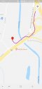
Here is a picture of Waffle House and Shell from google. Its not the best picture but it looks like a clear view could be had from Waffle House.The Waffle House is actually a little past the Shell and there's a small incline there that may make it hard to see the Shell from the Waffle House with any good detail. They may have seen the cars pulling out though, if they used the red light to get on Government.
Attachments

Yes, I agree. Even though google looks like it was last updated in the area of the Shell around 2017 its possible on some of the buildings to see CCTV. But as you say its impossible to know if the CCTV was operational. Does Mobile have traffic cams at major intersections? Other than the Waffle House are there any other locations in the area that are 24/7 that we could put on the map as being places where DNV might have been seen by somebody? The service road configuration also seems to make it tough to understand traffic patterns if you aren't local as there seem to be dividers along the route in odd places. Which route do you think DNV took when driving from Dublins to Shell?Me and my wife done some riding around and behind the shell station it's basically a business district. There were tons of cameras basically in front of every business. Not sure if they were working or not.
Here is a picture of Waffle House and Shell from google. Its not the best picture but it looks like a clear view could be had from Waffle House.
In my head the it was closer to that red light, so you are probably right! Someone could have seen something.
As I understand the events right now, they traveled the interstate. This is the most logical way to the Shell from the interstate. Right onto Govt. then slight right onto service road.Yes, I agree. Even though google looks like it was last updated in the area of the Shell around 2017 its possible on some of the buildings to see CCTV. But as you say its impossible to know if the CCTV was operational. Does Mobile have traffic cams at major intersections? Other than the Waffle House are there any other locations in the area that are 24/7 that we could put on the map as being places where DNV might have been seen by somebody? The service road configuration also seems to make it tough to understand traffic patterns if you aren't local as there seem to be dividers along the route in odd places. Which route do you think DNV took when driving from Dublins to Shell?
Attachments
Which road would make the most sense in your mind being local to go down to get from Dublins to Shell at that hour of the night?In my head the it was closer to that red light, so you are probably right! Someone could have seen something.
Is the top of your map Dublins and the bottom Shell?As I understand the events right now, they traveled the interstate. This is the most logical way to the Shell from the interstate. Right onto Govt. then slight right onto service road.
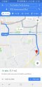
Got it! This makes it so much clearer. Thank you for posting this picture. Its also interesting as the timing to get from Dublins to Shell is faster than I had initially thought based on the distance.This is the suggested route from Dublin's to Shell, which does use the interstate briefly.
ChiCubs2016
Well-Known Member
- Joined
- Aug 7, 2018
- Messages
- 1,376
- Reaction score
- 11,808
Theres alot of bodies of water in mobile that someone could drive a car in. But around the shell station there really isnt that many. But you could drive as little as 10-15 minutes and find plenty.
Good Morning Folks! So glad DNV's thread is back.
Regarding bodies of water, previously locals said the water in the area are too shallow to drive a car in and not be seen. Are they other 10-15 minutes away that would be deep enough to hide a car? Any locals want to investigate and share maps that shows distances and route?
It really depends on the time of day in which you're traveling. During work hours and work/home commutes, traffic along most of the possible routes is horrendous and could take MUCH much longer.Got it! This makes it so much clearer. Thank you for posting this picture. Its also interesting as the timing to get from Dublins to Shell is faster than I had initially thought based on the distance.
ChiCubs2016
Well-Known Member
- Joined
- Aug 7, 2018
- Messages
- 1,376
- Reaction score
- 11,808
It really depends on the time of day in which you're traveling. During work hours and work/home commutes, traffic along most of the possible routes is horrendous and could take MUCH much longer.
And do you think 12 minutes is accurate. I ask because regardless of the time of day, area, none of the direction sites have ever been accurate for me. Always have to add time. One person here said they drove the same time at night on the same day of the week and there was traffic. I always feel sites do not allow for the right amount of traffic. What are your thoughts?
Edited for typos (late getting my coffee this morning).
Last edited:
And do you think 12 minutes is accurate. I ask because regardless of the time of day, area, none of the direction sights have ever been accurate for me. Always have to add time. One person here said they drove the same time at night on the same day of the week and there was traffic. I always feel sights do not allow for the right amount of traffic. What are your thoughts?
After 11 PM on a Tuesday, I feel like the drive would definitely be possible. The hang up occurs when you're in the bumper to bumper traffic and get stuck on one of the major roads like Airport Blvd. or University. The lights are back to back almost the entire length of the road and they're lined mostly restaurants/shopping facilities that would be closed or close to closing at that point. For the most part if you can can catch one green light when it first turns green, and traffic is steady to none, then you're going to make it through several before having to stop again.
Edited to fix typos
ChiCubs2016
Well-Known Member
- Joined
- Aug 7, 2018
- Messages
- 1,376
- Reaction score
- 11,808
After 11 PM on a Tuesday, I feel like the drive would definitely be possible. The hang up occurs when you're in the bumper to bumper traffic and get stuck on one of the major roads like Airport Blvd. or University. The lights are back to back almost the entire length of the road and they're lined mostly restaurants/shopping facilities that would be closed or close to closing at that point. For the most part if you can can catch one green light when it first turns green, and traffic is steady to none, then you're going to make it through several before having to stop again.
Edited to fix typos
Gotcha. Not being local it is hard for me to figure out what type of road the service road would be. Service road had me a little confused. I think in my area this is called a business road. Some pictures look busy and traveled but some pictures make it look like a road I would not travel alone at night.
Gotcha. Not being local it is hard for me to figure out what type of road the service road would be. Service road had me a little confused. I think in my area this is called a business road. Some pictures look busy and traveled but some pictures make it look like a road I would not travel alone at night.
The service roads are basically smaller roads that run parallel to the interstate to give people access to the businesses along the interstate between exits. They typically aren't used very much at night unless you need to get to one of the roads that doesn't have an exit. Ex: Dauphin Street and Airport Blvd. run parallel to each other. You can see one exit from the other because they're less than half a mile from each other. Most people still travel from one to the other via the interstate instead of the service roads.
ChiCubs2016
Well-Known Member
- Joined
- Aug 7, 2018
- Messages
- 1,376
- Reaction score
- 11,808
The service roads are basically smaller roads that run parallel to the interstate to give people access to the businesses along the interstate between exits. They typically aren't used very much at night unless you need to get to one of the roads that doesn't have an exit. Ex: Dauphin Street and Airport Blvd. run parallel to each other. You can see one exit from the other because they're less than half a mile from each other. Most people still travel from one to the other via the interstate instead of the service roads.
Thank you. That is what we refer to business roads in my area. Makes perfect sense.
Thank you. That is what we refer to business roads in my area. Makes perfect sense.
You're welcome. Most of the service roads end up basically merging traffic at some point. The one by the Shell Station basically ends at the light just past the Shell and it's not a heavily used service road. Plus it would be easier to veer onto it from Government (I posted a picture earlier in the thread) to get to the Shell because you'd have to pass the Shell and do a u-turn at the light otherwise. That area in general isn't highly traveled at night because it's mostly businesses- car dealerships, a shopping center, etc.- that wouldn't be open. There is a pretty large subdivision just pass the Shell, but not something that's just booming with traffic. There aren't any restaurants or bars right there really, so most people would be around the Airport area. Im sure people would be traveling through the area, but no where they would really be stopping in that general vicinity.
That picture I posted that's the river it is plenty deep enoughGood Morning Folks! So glad DNV's thread is back.
Regarding bodies of water, previously locals said the water in the area are too shallow to drive a car in and not be seen. Are they other 10-15 minutes away that would be deep enough to hide a car? Any locals want to investigate and share maps that shows distances and route?
The water I posted is easily 12-40 ft deep. Theres always ships coming in and out so it's super deepGood Morning Folks! So glad DNV's thread is back.
Regarding bodies of water, previously locals said the water in the area are too shallow to drive a car in and not be seen. Are they other 10-15 minutes away that would be deep enough to hide a car? Any locals want to investigate and share maps that shows distances and route?
- Status
- Not open for further replies.
DNASolves
Online statistics
- Members online
- 98
- Guests online
- 2,567
- Total visitors
- 2,665
Totals may include hidden visitors.