Rocket333
Well-Known Member
- Joined
- Dec 29, 2014
- Messages
- 992
- Reaction score
- 4,990
So did some testing today on a few apps that I had read about from research elsewhere and with the help of TDawg explaining how they all work.
Pokemon Go and also Ingress, both apps that work on Google maps data in real-time.
In Byron Bay there were several locators and markers that followed along some of Theos route. They included Tallows beach, Milne track, Patterson St, The REC fields, Kingsley St and an area above cosy corner around the location he went into the bush,
When you look at the map you could be convinced with the possibility Theo might have been playing either of these games at the time.
Sadly when I visit CC there was nothing on either the apps making me walk up into the bush to chase anything and the same at Tennyson so IMO I do not believe he was using either these apps.
(attached map for REF)
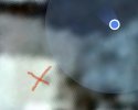
I also walked along Tennyson and screen recorded my location comparing it to Theos map of where he walked and where I stood the blue dot was well incorrect and the blue radius circle showed me the approx location in which I would say was about 5m from where I actually was.
I can't say with any certainty with what I tested today that Theo was on the slab, in the cricket nets or under the tree where the Nitrous cylinders where. One image here I stood on the slab and it appears close on here but the other is when I stood off road nearly in house garden yet still showed me way off and location out
Because all the 3 areas are so close to each other you just cannot tell.
I just tried this at home. I’m completely still in my house yet the blue marker has had me outside moving around for minutes now. The dot is nearby (moving around metres away in my yard) and sometimes jumps to where I actually am, but it’s not consistently pinpoint accurate.