Australia Australia - Theo Hayez, 18, Belgian backpacker, Byron Bay, 31 May 2019 #4

DNA Solves
DNA Solves
DNA Solves
Yes other markers were also written off.
It’s definitely possible.
I agree but just prior to the 1:49 timelapse it took him 1 minute to do this:
TENNYSONWALKBACK.png
that is a difference of approx 5x in speed
TENNYSONWALKBACKREC.png
but if you get into a vehicle that would explain the discrepancy and it would offer an explanation for the pins considered as anomalies.
 
speed along the yellow line would have been approximately 9km/h so much higher than the 6km/h Theo has been walking on average in other parts of the route. typical jogging speed ranges between 6.4 to 9.7 km/h
 
I'd bet this is a spot where the connection to the Massinger tower would become difficult and the phone connected to Ballina.

foothpathlighttower.png

From the Coroner's findings:

"did connect to the Ballina tower during three of the abseilers (green, blue and red) descents but not the fourth (purple) descent; "

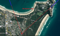
I've added a screenshot of the abseiling experiment on top of google maps and marked the spot in the image above:

ballina2.png

It's a spot that is within 300 feet of houses to allow for a wifi handshake.

300ftwifi.png

It's also a spot to sit down, use your phone and send some text messages.
From the Coroner's findings:

"at 12.55am, Theo sent a brief message on WhatsApp to Emma. The message was in French (“merci”) and continued a discussion thread from earlier that evening; (e) at 12.56am, Theo sent a message on WhatsApp to Loic Speiss a German backpacker Theo had met in January 2019 in Melbourne and travelled with for about a month. The message was in French and responded to a message from Loic sent earlier that night, at about 10.30pm, asking Theo
if Byron Bay was a “surfers paradise”. In his response Theo used a slang expression meaning something along the lines of “yes, totally!”"

Right after that spot, the footpath continues downhill and is quite steep:

foothpathlighttowerdownhill.png

To me, this looks like a spot where one could tripp and maybe fall or lose balance and drop a phone. In the dark, it wouldn't be easy to find it even with a flashlight.

If the phone dropped it could explain why it stopped transmitting data.

From the Coroner's findings:

"At 1.02am, Theo’s phone stopped transmitting data. It reconnected to the network at 6.17am but there was no further user activity."

That spot is a great place to view the sunrise and I've read it was one of the popular activities among tourists in Byron Bay.

Sunrise for June 1 2019 was at 06:30.

People going to see the sunrise would be walking that path at 6:17AM, right before.

Someone picked it up, it reconnected to the network and it remained in the area. If the phone dropped it would have likely had a broken or scratched screen, nobody would be interested in keeping a broken phone.

As for Theo's phone not connecting to one or two very nearby towers, from what I've read there can be many reasons why, the obvious one is you're already connected to a tower, and also being too close when there's a better connection to a tower further away. Claiming Theo couldn't have gotten to the headland simply because his phone didn't connect to a specific tower is false IMO. When the signal from the Massinger tower was weaker Theo's phone connected to Ballina and the route as outlined above is clearly in sight of the Ballina Reservoir tower.

So Theo could have walked out of there but without his phone. IMO.
 
can a vehicle pass through that gate/gap? (this is on Cowper St right in front of the last house on that street)

recgate.png

If so I think the movement across the field could have been like this (on the other side of the field there's an entry right next to where the white van was parked):
movementvehicle.png
 
You've seen the satellite photos posted by BruceBanner. On 3 different dates in 2019, a dark blue station wagon could be seen parked at the cricket nets. In 2 of those images, a white van was parked in front of one of the houses on Tennyson next to an entry to the REC field (see earlier posts).

Here's a screenshot from google street view looking from Cowper St to Tennyson:
cowperstjuly2019.png

And here's a screenshot on Tennyson:
TennysonstApril2023.png
 
You've seen the satellite photos posted by BruceBanner. On 3 different dates in 2019, a dark blue station wagon could be seen parked at the cricket nets. In 2 of those images, a white van was parked in front of one of the houses on Tennyson next to an entry to the REC field (see earlier posts).

Here's a screenshot from google street view looking from Cowper St to Tennyson:
View attachment 464678

And here's a screenshot on Tennyson:
View attachment 464679
Great spotting.
 
If the plan was to drive to Milne, and from the movement of Theo's cell phone I believe it was, you'd most likely follow the yellow path. I've marked what I think are security cameras along that path (magenta colored). I couldn't see any cameras on Marvell St but it appears as if there are at Marvel Hall on that street. Assuming the driver was avoiding cctv footage of his vehicle that would mean that intentions were bad from the start.

drivingtomilne.png
 
The Ballina connections are important IMO. It could help locate Theo's phone if it's still in the area.

From the NSW Coroners' Inquest Findings:

"The phone connected to the Massinger Street tower for most of the period. On three occasions, at 12.29am, 12:58am and 1.02am, the records show an almost simultaneous connection (i.e. within the same minute) to the Ballina Reservoir tower. This suggests that the signal that was being received from the Massinger Street tower deteriorated or disconnected and the phone scanned for other towers in the vicinity. It also suggests that the signal strength and quality being received from the Ballina tower was higher than the lighthouse tower even though it was much further away. One reason for this could be that the phone was in direct line of sight of the Ballina tower antenna(e)"

ballinaconnections.png

The magenta or purple beam is the line of sight from the Ballina Reservoir Tower and the light blue beam comes from the tower on Massinger/Paterson St. The abseiler experiments were done in the area around Cape Byron Lookout Point (I'm referring to the actual text on the image) and phones in that area connected to Ballina.

#1,2 and 3 are the spots where I think the three connections 00:29, 00:58 and 1:02 could have been made to Ballina.

The Ballina Reservoir Tower:
ballinareservoirlineofsight.png
 

Attachments

  • 2023-12-02 14_27_41-Window.png
    2023-12-02 14_27_41-Window.png
    873 KB · Views: 4
and the connections to Ballina at 00:58 and 1:02 are in the 60°angle area Telstra indicated Theo's phone last ping originated from:
60degrees.png

The blue line is an extension I made of the red line seen on this image posted by forum member SouthAussie (attached)
 

Attachments

  • telstra60.png
    telstra60.png
    873 KB · Views: 4
Probably the most important interview during the inquest was with Prof Seneviratne and he seemed biased. Very cooperative in answering Mr. Harrington and almost reluctant to address any question from Mr Evenden. IMO.

Also, I don´t understand why a map with timing advance data made by JP was used during that interview.
 
The map JP provided on which he plotted Time Advance data from two cellphone towers (Ballina and Massinger)
provides important insight into the movement of Theo's cell phone. I think attempting to locate a phone based on two sets of data instead of at least 3 for proper triangulation is a difficult task even for an expert. It can provide a rough estimate of the location of the phone but in this particular exercise, it appears as though it is an attempt at providing a more exact location of the phone e.g. the dots in different colors. And that's not possible. IMO.

Looking only at the Ballina TA we see two different TAs, one is 78 meters (LTE) and the other 550 meters (GSM).
Indeed, in the inquest, it's mentioned Theo's phone started using 3G more frequently after midnight.

I've read that, at least in the case of GSM, the TA line is not a maximum distance. For example, if the Timing Advance is 3 then the actual estimated distance the phone is from the tower is between 3 and 4. This means it can be up to 550 meters further away.

ballinaTA.png
( the strikes are times related to TA from Messinger)

The Ballina arc at 1 AM is about 150 meters north of the light tower (direction little wategos).

Along that arc and considering we know in which area Theo's phone was previously you'll find there's only one place to walk, and that's the Cape Byron Walking Track behind the light tower.

That area is also the first time Theo's phone comes within 300 feet of houses since walking off Milne Rd. at around 11:33 PM. This could explain the handshake at 00:58.

It wouldn't be possible to have an extra TA figure at least not in GSM simply because that would put the phone in the sea at little wategos. And there isn't any.

More data indicating Theo's phone was located between the lighthouse and little Wategos:

TELSTRA TA data

At 12:05 TA 1717 meters (Cosy Corner)

At 6:17 AM TA 2108 meters (this is past the lighthouse in the direction of Wategos).

Other observations from the inquest:

-many factors can affect the accuracy of TA data.

-poor signal reception around CC and headland.
 
The following scenario seems possible to me:

(1) At the REC fields Theo became part of a group. He was following along. His actions reveal he was at ease yet cautious enough to check his location frequently. I don't believe the people he was with from the REC field to the time of the phone disconnecting had the intention to rob or hurt him. They'd had plenty of opportunity to do so in isolated areas such as the bushland, Thalow Beach, and Cosy Corner. I don't think he'd have gone that route with only one stranger he'd just met for 5 minutes. He'd had some wine and a few beers but wasn't intoxicated to impair his judgment in such a way. IMO.

(2) Theo lost his phone on the Capy Byron footpath. This could be significant because he'd have no access to directions from that point on (he checked for directions to WU until just before the cell phone lost connection at 1:02 AM). Maybe now he loses contact with the people he was following. If he was the last person walking in a group they may not have noticed until they had left Theo far behind. It was windy, very near the ocean, and dark, and that path goes downhill so you walk faster. Theo would have tried searching for his phone which would have stalled him quite a bit before he gave up looking for it. Searching that area for Theo's phone makes sense IMO, even after all these years.

(3) Theo managed to walk out of the headland, most likely in the direction of Wategos Beach/The Pass. He had been checking his map for directions to WU. From the lookout at Cape Byron Google Maps directions are to follow the path to Wategos. From this point on there aren't any clues as to what may have happened to Theo. But he seems to have disappeared between Wategos and The WU hostel, as that would have been the obvious direction he'd be walking (He'd been to The Pass the day before, on Thursday, took a photo there, so he had some knowledge of the area).
 
Although I don't think Theo would have continued down that footpath alone without a light, seems unlikely as it would have been too dark and scary frankly and he could have simply turned around towards the light tower, there was maybe a light on at the cottages I've seen this in some drone footage at night from the area and could have continued walking down Lighthouse Rd. into town. Btw, the light tower on Lighthouse Rd, look where the antennas point to, not at the light tower.
LighthouseRdTower.png
 
According to the police theory Theo walked along the grassy part of the cliff up to the headland and at 1:02 AM something happened, the last part of the climb is described as very steep and unstable ground, and he fell of the cliff into the water and was swept away in the sea.

The drone footage in the video above gets close to that area.

If you´re on a steep part of a climb and the soil is slippery I'd think you would slide downwards, not sideways. JMO.

Climbing up to the road from the beach takes about 10 minutes during the day and probably a few minutes longer at night.

Theo sends messages on WhatsApp at the following times:

00:55 "Merci"
00:56 "ouais grave"

And after that time he even used Google Maps for directions.

I believe it's very unlikely Theo would have texted and used maps if he was on the last part of that climb to the headland, in the dark. Very low probability IMO. Theo had even sent a WhatsApp message earlier that evening saying he'd be slow to respond because he was going out.

Either he's still at Cosy Corner or he has managed to get to headland. IMO.

Timing advance information shows his phone is moving away from the Ballina and Massinger phone towers so he couldn't have been at Cosy Corner any longer.

And then there's the phone, it didn't fall into the sea. It remained operational until 14:47 that day, and remained in that area, with Telstra data locating his phone in an area past the lighthouse, which coincides with timing advance data from the Ballina Reservoir at 1:00 AM.

The fact is, the only information we have about Theo's whereabouts that night after leaving CM is the cell phone location data and the application usage of his phone. It's this information that should guide us to try and find out his movements, not trying to fit a theory in the data.

I think the police theory is an example of the latter. The telco expert Mr. Seneviratne who was interviewed says the signal was very poor at Cozy Corner and during the phone's movement away from the phone towers in the direction of the lighthouse. Yet he says he has a high degree of confidence in the Timing Advance data for the measurements between 00:05 and O1:02.

When the phone reconnects at 06:17 and until 1:47 PM there's also timing advance data available, locating Theo's phone even further away, however, Prof Seneviratne says this data can't be trusted because the signal is very poor. High degree of confidence in a poor signal, ignoring information for a very poor signal.
 
16 February 2024
1708353318027.png

''The godfather of missing backpacker Theo Hayez has said lessons learned from his disappearance could help shed light on what happened to Samantha Murphy.

The 51-year-old mother of three left her home at Eureka Street in Ballarat East, Victoria on February 4 to go jogging and has not been seen since.

The case is eerily similar to that of Mr Hayez, a Belgian teenager who vanished without a trace while visiting Byron Bay on a backpacking trip around Australia.''

''The 18-year-old was last seen at about 11pm on May 31, 2019, outside a nightclub on Jonson Street - with his family later successfully petitioning Google to release detailed phone data that tracked where he went afterwards.

Mr Hayez's godfather Jean-Philippe Pector this week said he was shocked that coronial findings on what happened to his godson had not changed the way missing persons cases are handled.''
 

Hey guys I just found a great video on Instagram showing the area of Cape Byron lighthouse for anyone who hasn't seen the area. I think its an excellent example of how a Phone could be thrown off the top and be caught in any number of crags and never be found again even if it is there.
 

Members online

Online statistics

Members online
188
Guests online
2,169
Total visitors
2,357

Forum statistics

Threads
600,107
Messages
18,103,759
Members
230,989
Latest member
Helangel
Back
Top