)
He walks down the Milne beach track to Tallow Beach. (10 to 15 minute walk)
I would just like to clarify this point, according to the gps map of Theo’s phone in The Australian, he doesn’t actually walk down Milne beach track. If you open google maps using safari, it names and shows Milne beach track, it veers off to the right, it’s quite a small track at the split. I know this cos I walked past it today.
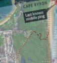
I’ve been interested since the gps data showed he didn’t actually follow the Milne track, he went further north up what I now know is a fire trail, it doesn’t have a name but leads right behind the Arakwal depot, you can see it in the map, it’s actually the most prominent of the trails on google maps on satellite (cos this is a fire trail, a vehicle can go down, but a vehicle could not go down the Milne beach trail).
I was interested in this cos on google maps it seems that the fire trail simply comes too an end, but Théo then veers right on the map released, so I figure there must be a way.
It took about 10 mins to come to where it looks like the end of the fire trail from Milne St. Where the trail looks like it ends on google maps satellite is kinda like a cross junction, on the left there is a path that actually leads too Tallow Beach Rd. I could see the cars and people walking past, it’s probably about 70-100m out to the road, and it’s big enough to fit a vehicle through out onto Tallow Beach Rd and there is a chain between two posts which is locked off the road (makes sense being a fire trail a vehicle has access from Milne street and Tallow Beach Rd entry).
Back on the cross junction there is a path going straight ahead, it’s only a walking path but actually was well worn, I didn’t walk this but the direction is towards Tallow beach carpark.
Then there is a path on the right, it was not well worn at all, there was a tree hanging over it about 6 and a half feet tall and a cluster of sticks on the path.
Now honestly the only reason I chose to walk this path, the path on the right was cos it matches Theo’s phone gps. I didn’t feel great going this way and it was the middle of the day, so can’t imagine being in this spot around midnight, I doubt you would even see the path on the right, even with a torch, cos from there it would make sense to take the two other paths that were visually more appealing and well trodden.
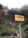
Now walking down this path about 100 meters in I came across a sign from 2018 that stated somebodies structure was to be removed at a certain date as it was illegal, and there was nothing apart from the sign that would alert of a structure being there at anytime, obviously someone’s permanent camp.
I kept walking down the path and about 100 meters further I came to what appeared to be a dead end, but I looked left and I could see a path that was going to take me towards the beach, as I could now hear the ocean, and then I looked right and I saw about 25 meters in the scrub an actual camp, it had clothes hanging on a clothesline between two trees, there was a tent, so it was obviously an in use camp. It was at this time I decided to turn around and head back cos it just freaked me out. I did alert appropriate authorities about the camp and location but was told there are hundreds of camps in that area.
Just wanted to share my journey with you all to hopefully shed some more light on the case.
Photos below:
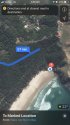
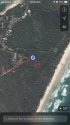
1. (Top left) The path I took today from Milne St and blue dot showing the location of cross junction
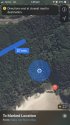
2. (Top right) At the cross junction looking straight ahead (track towards the carpark)
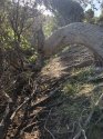
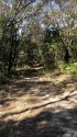
3. (Middle left) Looking right at the less travelled path where it looks like Théos phone went.
4. (Middle right) Looking back at the fire trail I just walked
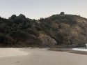
5. (Bottom left) Looking left towards Tallow Beach Rd
6. (Bottom right) The sign I found along the less trodden track


")