
You are using an out of date browser. It may not display this or other websites correctly.
You should upgrade or use an alternative browser.
You should upgrade or use an alternative browser.
Australia Australia - William Tyrrell, 3, Kendall, NSW, 12 Sept 2014 - #27
- Thread starter Coldpizza
- Start date


New Posts
-

-
 KY- I-75 Active Shooter Targeting Vehicles
- Latest: arielilane
- Status
- Not open for further replies.
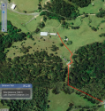
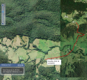
Hi guys. here is a very close up of the unnamed road & the private rd. Notice how thickened the unnamed road is at this point - 14 metres... plus can anyone see the power lines right there (3 faint ones that i can follow directly to the private home)? must be easy enough to link through to the private rd here...
i'm studying today, so i will show u a few more locations as the day goes on, as i'll be pretty much glued to my computer...

i'm studying today, so i will show u a few more locations as the day goes on, as i'll be pretty much glued to my computer...
Attachments
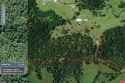
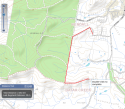
as Frogwell says, the "horrible act" is usually within a short distance, and then the body is usually found double the distance away or thereabouts. here's a map of stoney creek rd to the tree stump. if the tree stump writing was left by the perp, it would make sense it's a little further away still -- but still in the vicinity. One map shows the main (thicker roads) through the forest, which i took, whereas the other is panned in to show many more linking smaller roads, that i didn't want to go down. my vehicle is an AWD with large on road tyres but not proper 4wd tyres and thus not as much clearance, but nearly twice the clearance of a normal car (an enthusiast told me this recently when looking at my car). i nearly bottomed out at the end of williams st, in 3 spots, i definitely scrapped the bottom of my car, but that was the only area i had trouble all day.


Attachments
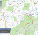
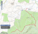
ok two maps i screen shotted this morn. the first shows my route with me stopping at the humpy house, the 2nd shows a quicker route all the way to 152 batar. i saw the quicker route but it looked more 4wdish so didn't go there...
there's a third thumbnail here, it shows the end of albert through to williams and back, i did this whole route, but for brevity, you could say just from williams street to the humpy is the route i took. i went all the way down to wiliams to check it was indeed beneroon & then went back


there's a third thumbnail here, it shows the end of albert through to williams and back, i did this whole route, but for brevity, you could say just from williams street to the humpy is the route i took. i went all the way down to wiliams to check it was indeed beneroon & then went back
Attachments
frogwell
Former Member
- Joined
- Apr 17, 2015
- Messages
- 2,147
- Reaction score
- 3,001
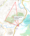
Thank you for all the maps Iailwa. I would be interested to see a map that has the following three points highlighted, and then see what is at the centre of those 3 point. the points are, 48 Benaroon Drive, the point where the tree stump is and 92 wharf road John's River, just to follow an idea. If you have the time and can assist with a map like that I would be grateful. I think the central point to those 3 locations is Charles Yard Road in Middle Brother State Forest. MOO
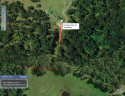
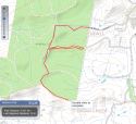
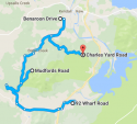
ok here' s the simplest map simply highlighting those 3 areas, plus I put in the location of charles yard road, cause i didn't know where it is. thats veery interesting btw! -- at the end of stoney creek rd. nice sleuthing!
when it says mudfords rd, that's the stump
now, what do you want exactly - happy to do -- any of these below?
1. use the red lines to show distances between the 3 points of interest
2. use the shortest route to the stump from stoney
3. use batar end - or cul de sac end of benaroon
4. calculate the area of the 3 poi...
not too hard to do any of these. if you want distances it might be better to do them individually, otherwise it ]will just combine the total distance...
Attachments
frogwell
Former Member
- Joined
- Apr 17, 2015
- Messages
- 2,147
- Reaction score
- 3,001
That is very kind of you to do, you must hate studying, I hope you can incorporate some of what you are doing here into your studies. Well, since you asked, I would like to find the most central spot from the three points, not including Charles yard road and the distance (as the crow flies) between each point. TIA Just to be clear about previous posts I have made in regards to specific properties, I am in no way implying that people associated with those properties or the properties themselves are in anyway associated with WT's disappearance. MOO
That is very kind of you to do, you must hate studying, I hope you can incorporate some of what you are doing here into your studies. Well, since you asked, I would like to find the most central spot from the three points, not including Charles yard road and the distance (as the crow flies) between each point. TIA Just to be clear about previous posts I have made in regards to specific properties, I am in no way implying that people associated with those properties or the properties themselves are in anyway associated with WT's disappearance. MOO
yes can incorporate into study
") plus it's just a quick 10q multi choice
plus it's just a quick 10q multi choiceso as the crow flies correct? my comprehension is failing me a little today. uni reading was what freakn complicated -- has given me a headache.. i'm cleaning as well, so double head ache
Took some pandadol so almost gonefrogwell
Former Member
- Joined
- Apr 17, 2015
- Messages
- 2,147
- Reaction score
- 3,001
https://www.google.com.au/maps/plac...f66127b6097f3!8m2!3d-31.6870114!4d152.6827365
Just going from looking at the map, the most central point seemed to be Grey gum ridge Rd. There is a feature around that spot which is called Bird Tree Track and it has photos. It kind of made me jump when I looked at it. Maybe I am just spooked, now that my thoughts around WT's predicament have become more focused. MOO
Just going from looking at the map, the most central point seemed to be Grey gum ridge Rd. There is a feature around that spot which is called Bird Tree Track and it has photos. It kind of made me jump when I looked at it. Maybe I am just spooked, now that my thoughts around WT's predicament have become more focused. MOO
https://www.google.com.au/maps/plac...f66127b6097f3!8m2!3d-31.6870114!4d152.6827365
Just going from looking at the map, the most central point seemed to be Grey gum ridge Rd. There is a feature around that spot which is called Bird Tree Track and it has photos. It kind of made me jump when I looked at it. Maybe I am just spooked, now that my thoughts around WT's predicament have become more focused. MOO
yes i've seen it heaps on the map - this road, & i passed it at some point. it connects stoney & the stump quickly if i remember correctly...
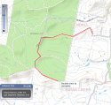
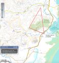
ok i have a triangle of the 3 places
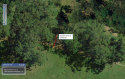
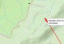
the 2nd image is just where i loosely predicted is the centre point from a panned out image - & lo * behold - it's turns out to be right near picnic spot. this is a loose guess but i coulddnt tell where it was exactly until i zoomed in - spooky hey
i'm not sure if i can calculate the centre point. if someone whats to get out the trig set go ahead & good luck to you !
Attachments
close up of where i landed - the bird trail...? how creepy is that. altho i don't know how it's related to previous posts...yet. could this be where someones lives or plays or hangs i wonder? I know stats wise it might be a good spot for *remains (try not to think about it) but it also displays a real comfort zone, and the *remains may be elsewhere, such as up stoney to charles yard rd. if you lived and played in this vicinity would you necc *advertiser censored* in ur own backyard?
dying to know what went on there!

dying to know what went on there!
Attachments
frogwell
Former Member
- Joined
- Apr 17, 2015
- Messages
- 2,147
- Reaction score
- 3,001
https://www.visitnsw.com/destinatio...ea/kendall/attractions/bird-tree-and-benaroon
Bird tree is a giant tree. Benaroon is another giant tree and the walking track at that site takes in both trees.
Bird tree is a giant tree. Benaroon is another giant tree and the walking track at that site takes in both trees.
frogwell
Former Member
- Joined
- Apr 17, 2015
- Messages
- 2,147
- Reaction score
- 3,001
close up of where i landed - the bird trail...? how creepy is that. altho i don't know how it's related to previous posts...yet. could this be where someones lives or plays or hangs i wonder? I know stats wise it might be a good spot for *remains (try not to think about it) but it also displays a real comfort zone, and the *remains may be elsewhere, such as up stoney to charles yard rd. if you lived and played in this vicinity would you necc *advertiser censored* in ur own backyard?
dying to know what went on there!
Could be an area where the person works or plays, e.g. hunting in state forest, walking, 4 wheel driving. Although the person who took WT may well have been a person on holidays, I get a sense that if they drove into State Forest from a suburban road, that they are a person who is very familiar with the area to take advantage of an opportunity when it presented itself. The person may not live in Kendall but a nearby town and work around the forests. Sounds somewhat like a particular POI but what vehicle....?
- Status
- Not open for further replies.
DNASolves
Online statistics
- Members online
- 162
- Guests online
- 2,170
- Total visitors
- 2,332
Totals may include hidden visitors.