CA - Jonathan Gerrish, Ellen Chung, daughter, 1 & dog, suspicious death hiking area, Aug 2021 #2

DNA Solves
DNA Solves
DNA Solves
Status
Not open for further replies.
Yes, experienced hikers can make mistakes.

When I hike I typically have a backpack w/survival basics such as a first aid kit, fire starting kit, knife, and a handgun. If it's going to be hot, which is almost always, I carry a cool towel I can wet to cool me down. I always carry snacks, for a longer hike I'll pack a lunch. I almost always have rain gear and a rope. I also go out with a 3L bladder full and usually some 1L Smartwater bottles.

I can't tell you how many bottles I've given out on the trail but it's been many.

I almost always have a cooler in my truck with water, beer, and juice.

One of the worst hikes I ever did was last November when I hiked out to Nobles camp where Mostly Harmless died. Only a 5 mile hike on a gravel road. It was brutally hot and even though I started early, by the time I made it to the camp the sun was out and I bet it was over 100 degrees with the humidity. I actually hung around the well shaded campsite for a couple of hours looking for stuff and waiting for the sun to pass a bit. I had been smart enough to drop a liter of water a couple miles in for the way back and wouldn't you know it, I needed it.
These are good tips, thanks. One reason I’m so personally invested in this story is because I’m planning on visiting this part of the US which will likely mean hiking in areas like this. This story plus that of the poor lady lost on the Appalachian trail has absolutely convinced me on PLBs and ALSO some kind of GPS call device (I’m not sure if a type of satellite phone). One good habit I have I when I hike here (U.K.), I follow the rule of always telling someone where I’m going and how long it should take me. Even if it’s a receptionist at a hotel or whatever. I think this is probably one of the best things anyone can do and I just wish that had happened in this story. Apologies for going off-topic.

I am much clearer on the maps today, but I'm still very unclear about which direction they trekked out from the car (i.e, Hites Cover or SL), or if they started out on one trail & doubled back & switched to the other. Does anyone know, or have an opinion based on your understanding of the evidence?

Another thing I've been pondering is if, say they were a few hours in on their proper chosen route, & already experiencing a degree of heat exhaustion (with cognition already being affected), might they have made a spontaneous decision to go further than they had planned or prepared for?
I’ve never had heat exhaustion or stroke. As mentioned before, my mother grew up in east Africa so we were religiously encouraged as kids to always wear hats and keep the back of our necks covered - usually with a bandana she would wet then tie back round our necks so that the water would be hit by breezes. I have seen people with sunstroke though and in my anecdotal experience it hits fast. They usually start feeling tired then weak then throw up, etc. So yes, it comes on fast from what I’ve seen. It’s also subtle so often people will be sitting wanting to ‘have a break’. They aren’t thirsty either which is another one that’s important to bear in mind as I think there’s often an assumption dehydration and sunstroke (heatstroke) are the same but not at all.

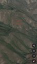
Also, apologies to the moderators as I don’t know the source for this but this is a graphic from a publication posted in the first thread that I think shows the assumed route they took. Next to it is my own image with the area circled that I sourced from Google maps to show the elevation of the final part.
 

Attachments

  • 3E0EE1AE-BABA-4982-907C-811E7A5E5FE1.jpeg
    3E0EE1AE-BABA-4982-907C-811E7A5E5FE1.jpeg
    142.4 KB · Views: 41
  • EFF0B4A4-7BB6-485E-BF0F-58809B93C478.jpeg
    EFF0B4A4-7BB6-485E-BF0F-58809B93C478.jpeg
    108 KB · Views: 43
Oh - on the topic of Personal Locator Beacons. They are awesome, but you have to turn them on for them to send the distress signal. So that's great if you're conscious or thinking clearly. If you're not thinking clearly, you might think you're fine and flipping the switch is unnecessary. If you don't turn it on, the PLB is basically as useful as a rock.
Unless they were struck by lightning, at least one of the parents would have known they were in trouble. I really don't think there would have been an issue activating a PLB if they'd had one.

A more significant problem might be that a PLB wouldn't work in that canyon, so even if they had had one, there would be no help. Since LE couldn't get their satellite phone to work, at least some PLB models would presumably have been incapacitated, too.

Every time I write a comment on PLB's, I plan to get one.... still working on it. They aren't cheap, but this couple evidently had no issue with budget that would prevent them from owning one. I can't actually imagine going off trail to explore mines without one, if that's what he liked to do.
 
These are good tips, thanks. One reason I’m so personally invested in this story is because I’m planning on visiting this part of the US which will likely mean hiking in areas like this. This story plus that of the poor lady lost on the Appalachian trail has absolutely convinced me on PLBs and ALSO some kind of GPS call device (I’m not sure if a type of satellite phone).
Snipped for focus.

De rigueur: the standard "10 essentials". Even the National Park Service posts these in highly visible places. The "10 essentials" have been elaborated over the years, but the basic principle is the same.Ten Essentials (U.S. National Park Service)

You'd likely be okay with a PLB OR a GPS call device. However, a PLB would be a good plan, your cell phone, a GPS, a paper map, and a compass. You should have ALL of these. If you're in a popular area, the National Geographic maps that are based on the USGS maps are excellent. They are printed on Tyvek.

For the first hike or two, especially if you're in a National Park, sign up for a "ranger walk". This will get you situated on good trail protocol, how extreme the landscape can be, etc. Also see if the Sierra Club (or Appalachian Mountain Club) or local hiking societies have hikes you can go on. This is a great way to be with people who know what they're doing, learn how to make trail decisions, etc.

You are unlikely to be on a trail with conditions like the one this family was on. For starters, this is not a "high interest" trail, so if you were a visitor, it would be a no-fun waste of time. Most people have the sense not to be hiking in these conditions. I just don't get it. They have to have had something unique in mind.
 
I just can't imagine any scenario where one of them wouldn't have been holding the baby come the end
Here's a scenario: Jonathan experiences heat stroke. He is incapacitated and unable to hold his baby. Ellen stays with Jonathan hoping that his condition will improve, but improvement wouldn't happen with temperatures between 103 and 109 degrees. Meanwhile, Ellen's condition worsens as she bakes in the sun. In a state of exhaustion (and/or delirium), she decides to go for help, but she only makes it 30 yards up the trail before collapsing. She was not holding her baby because she was too weak to carry it as she tried to leave for help.

If Jonathan and Ellen succumbed to heat stroke, I actually find it harder to imagine a scenario where they would be holding the baby.
 
August 14: John Gerrish researches Hites Cove hike via phone app.

I'm wondering if he made the same mistake dozens of online researchers have made this past week and confused the easier, much shorter, and comfortable "Hite Cove Trail" from the 140 to Hite Cove, with the brutal "Hites Cove Road to Savage-Lundy" trail. Perhaps, they saw the name of the dirt road by their house also being named Hites, and assumed they lived at the end of the same trail. That would also explain why they only brought 3L of water for 3 people and a dog.

But once you go down that exposed 5 miles of southern slope, there's no way out except to either go hiking to the 140 through the river 10 miles with a 1-year-old as the heat is increasing, or trying to get back up the 3-5 mile (reports keep differing) switchback you just came down. Possibly a scenario that by the time they realized they were on a much more difficult hike than they thought, the baby was already showing signs of heat stroke, and they pushed themselves harder than their bodies could handle back up that slope in an effort to save the baby.

And according to his All Trails Logs, most of his recent hikes this summer weren’t that long or difficult. And although his recent Activity List, has his completed Hites Cove saved, added and completed 4 years ago, I suppose in those 4 years, he could have forgotten where it was located and accidentally went on the wrong trail?

Also, check out these reviews of hikers that have attempted or completed the true trail. If only they had read the reviews perhaps they would have realized their mistake in advance.

https://photos.app.goo.gl/J9CfNCwZyKtFHEdY6
Yes this is exactly what I’m thinking! The online searches & the two close names are actually quite confusing
 
If it's 107º why wouldn't four creatures die "at once?" ("At once" is a relative term which could span minutes or hours.)
Exactly.

I'll even venture to say that if even they had made it to their car, they might still have succumbed as the car A/C might not have been sufficient cooling fast enough. MOO
 
Following this thread with great interest - sad, mystifying story :(

Chiming in with my 2 cents - a couple of years ago I used to walk my grand-doggo at lunch or early evening when his mom was at work. He is a 95 pound, black Labrador/ Husky mix with a thick double coat, and a love bug ❤️ In hot weather he would get tired quickly- and we’re in Chicago, flat and shaded residential area. 80 degrees or more I would plan short routes and walk him in grass to protect his sweet freckled feet. When he got too hot - he would just lie down. Nothing could convince him to get going again until he was ready! So there I’d be - standing in a strangers yards for 15 or 20 minutes!

I’m a distance runner who trains outdoors year ‘round - heat slows me down but I know what my limit is and plan for it. Go early, slow down, rest in shade, etc.

This leads me to a gut feeling that no matter how experienced they were - something unexpected happened - very likely the heat affected the doggo first and he refused to budge - poor thing just needed to rest and get cool, but no shade, so the rest wasn’t enough. Family refused to leave him (I wouldn’t leave my doggo!!) and the extended time in these hot conditions eventually overtook them all. At some point, decision making would have been hindered - they probably did the best they could and got close but then they ran out of time. One adult should have started for help sooner - but those decisions are not always easy to make in the midst of a crisis.

My humble opinion only - others have shared similar theories - thanks for letting me contribute. So sorry this happened to this sweet little family :(
 
Completely agree. Fwiw, AllTrails also displays temperature, heat index and daylight hours for every trail including this one. Conditions would have been easy to see if the trail was researched the day before, and I’m sure they checked their local weather too
https://www.alltrails.com/trail/us/california/hite-cove-road

Is there an Alltrails for the Savage-Lundy trail? The link above does not include the portion with the switchbacks. I searched but it does not come up, anyone else have more luck?
 
What do you believe is inadequate? I agree in extreme temperatures the correct answer is to wait for cooler weather, but I’m not sure if telling people to abstain works, in many areas of life.

I think the very hot temperatures combined with more people getting outdoors since the start of COVID (more flexibility and work-from-home situations) is certainly making this year terrible for heat-related deaths around here. This couple’s tragedy is likely indirectly related to COVID life changes because of their recent move. I believe there are more people doing recreational activities they’ve never tried before. Although this couple was fairly experienced, but perhaps not in deadly heat.

It struck me how many of the deaths this summer were of people who live or recently lived in the Bay area who just do not have adequate experience with heat.

In Death Valley for example they recommend FINISHING early, starting early is not sufficient. With the temps we are now seeing in the West it is not a bad comparison point.
 
Last edited:
I believe there has to be more to the tragic circumstances that happened here. These were well educated, presumably bright people, experienced in hiking. I just don’t see where, in any situation, you would think it’s a good idea to go hiking in that weather with a baby and dog. I have a husky cross and don’t even take her out walking when it’s more than 21c - she does not do well in the heat. In those temperatures the ground would be extremely hot and it would be like walking on fire for the poor dog. Not to mention the extreme heat for the baby sitting in a papoose type thing. Even if they did set off expecting it to be cooler, after getting out of their car and walking for 5 mins, they would realise it was a bad idea and turn back surely? I just don’t see any ‘right minded’ person doing so, which makes me think that maybe for whatever reason they were both ‘affected’ in some way before the hike, causing them to make a decision they would not normally make in their right minds? Just MOO.
 
Yes this is exactly what I’m thinking! The online searches & the two close names are actually quite confusing

Once the phone comes back we will have a route in all likelihood. If they went down the SL trail they had to know how steep it was, there are switchbacks. If they did the whole loop, that is quite a distance, and with the steep several miles climb out. I have seen the elevation change for SL listed as 1400 and as 1900, that is quite a climb in extreme heat.
 
Every time I write a comment on PLB's, I plan to get one.... still working on it. They aren't cheap, but this couple evidently had no issue with budget that would prevent them from owning one. RSBM
I just purchased one for my husband (and me) because of Philip Kreycik, our poor runner in Pleasanton from another thread.

Please don’t delay, Rickshaw! I care about your safety! We have very few friends who own one because the prices only recently were prohibitively steep. On our big mountaineering treks (Rainier, Hood, Granite) someone always had one, but often only one for 3-4 rope teams. And sat phones are still pretty steep, to the point that our friend bought one and returned it after a recent aggressive Grand Canyon trek. I do not condone, as it seems dishonest, but it saved him $600, I guess.

This is the best legacy these poor folks could leave us: the inspiration to take our safety more seriously.
 
This is the problem with a loop trip. There's psychological pressure to keep going on a loop and not turn back.

Absolutely. I'm a seasoned, experienced outdoorsman and have done stupid things like hiking a mile in thigh-deep snow (in jeans, no less) because I was already three miles in, and another time I hiked through ankle-deep slush in Birkenstocks for the same reason. As humans we're prone to error, especially errors in judgement, no matter how smart or adept we think we are.
 
Hey thanks for your thoughts. My responses follow.

Strikes me a dying even a couple of days apart is unlikely. Your loved one, maybe with a baby, is sick to the point they can't move suddenly - you move. You don't wait for a chopper. They were all found together. Maybe they decided not to, but if you're right on the trail, seems to me you move.

Heat stroke en masse? This was a wooded area or near one, as I recall. Dogs, babies, and folks shouldn't all drop off from heat stroke within moments or even hours of each other with water sources nearby capable of giving them algae bloom or whatever. Or at least it's waaaaaaay off the scale of likelihood.

I disagree with you relative to your thoughts about "zero evidence". <modsnip> You've got an entirely dead family here - plus the dog, on or near a trafficked trail. I've seen at least some speculation about murder. No third-party hangs around to murder the dog too, unless the dog's a problem. Not a mark on the dog. No.

You take out the dog because it's best for the dog, so it won't suffer in your absence.

I'm a lawyer, licensed in two states, 25 years now in practice. I deal in evidence daily. And you're staring at a ton of admissible evidence. Probative value? I agree, there's more to do here before drawing conclusions. I'm just sayin', I've got a fair sense of where this is heading.

Happy to be wrong, by the way. Maybe.


I respectfully disagree with you. You´re also wrong when stating that this was a "wooded" area. It used to be, but sadly no more since the disastrous Ferguson Fire back in 2018 which took out almost all the trees along and in the vicinity of the trail in question! So: Basically no shade whatsoever!
You´re also writing about this being a "trafficked trail".....Wrong again. As far as I know this trail (The Savage-Lundy Trail) is very little used in the summer season! Way too hot and no shade nearby and not really offering anything worthwhile in the shape of beauty and vistas, apart from the view of the deep valley bottom below....The day in question was also incredibly hot, unusually humid, and the air filled with particles from the huge burning fires in that part of California....Add a lack of enough water and the result would be fatal....My bet right now is on heatstroke...JMO.
 
I hope you’ll start to feel much better soon. This is his Alltrails. I agree it’s not especially indicative of any skill but it is interesting for a couple of things: a) he appears to have at least partially done the Hite Cove trail and that was four years ago, so reason says they likely had done this hike before or possibly only some of it (as far as I know, the sheriff has assumed they took the circular route but they may not have, I suppose). And b) he seems to have a habit for “afternoon” hikes around this area which I thought was interesting. Perhaps they did set out in the afternoon.

In any event, he seemed to be hiking to the south quite a lot for short hikes no more than a couple of hours at a time. From what I read elsewhere, they moved to Darrah so the house is thereabouts. Maybe they’d only done some Hite Cove (or he had, and that was before they married or likely were together) and they set out to make a day of it to do the whole loop.
https://www.alltrails.com/members/jonathan-gerrish
A question, please:
Is there any known, actual quote by Sheriff Brease where he states that this poor family was doing the entire loop???
If so, how would LE know that, I wonder...?
The only thing I can come up with here, is that LE somehow was able to confirm that there were no footprints/pawprints on the Savage-Lundy Trail on the stretch from where their Ford Raptor truck was parked at the gate and where the family was found further down the trail....
Any ideas?
 
Status
Not open for further replies.

Members online

Online statistics

Members online
156
Guests online
2,163
Total visitors
2,319

Forum statistics

Threads
601,889
Messages
18,131,488
Members
231,178
Latest member
Sabrinalyyn
Back
Top