New to this site. Long-time tracker (mostly throughout Asia and MidEast), but have lived in/around Topanga/Malibu most of my life. Several things stand out.
Access to the road on Rosas Overlook is locked. Rarely is it left wide open for someone to stumble down (in their car). It's a long drive down in - quite clearly - the wrong direction if someone is lost. Driving down to the end is with specific intent and, likely, the assistance of someone who opened one of the padlocks.
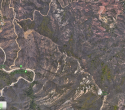
I assume a team as thoroughly examined on foot the single-track that follows the ridge connecting Rosas Overlook to Red Rock Cyn??? On Saturday (10/6) I was very close to this area and watched about 10 ravens/birds circling, despite shifting winds, in one tight area along this ridge path. Had I known for sure that no one had examined this area, and were I better prepared, I would have hiked to the location, popped a drone up, taken photos vertically through the brush, etc. In the attached photo, the center represents roughly where the birds were circling.
There are many other salient points, but as I'm new to this thread, I'll leave it at this. Sorry for the unknown - it is ALWAYS the worst feeling ever.