Let me get this straight... So what you are implying is that we have left out attainable information regarding Matthew's case?
Really????
In addition, what credentials have you established to respectably make the observation that only 40-50% of the posts on this thread are relevant when what you just posted serves no relevance whatsoever to this case?
No, I did not say 40-50% of the posts are relevant. I said the data contained within the board represents, roughly speaking, less than half of what is or at one time has been attainable data for this case. You think 100% of everything that could be known is known? Then why haven't you solved it? All of our posts confirm this with 1000 questions that remain unanswered. The missing pieces are either known to the police, culprit(s), the new gf, the roommates, any combination, or perhaps it wasn't obtained in time and is thus unattainable. Want an example?
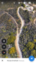
Tracking. In conditions very similar to those of Aug 10th, I've walked (and tracked) the trail from Stunt/Topanga Overlook to Rosas and down to Calabasas Peak rd (then back up). Very few people make this entire trek, and there is ample loose soil perfect for tracking prints. I easily tracked one person's prints from approx 4 days prior, saw he had a hiking pole, was likely left hand dominant, slid on the downhills and at some points on the trail one or more coyotes intersect. In fact, these tracking conditions begin (and sometimes end) right at the location where the car was allegedly stopped.
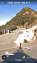
Car. Do we know anything of the evidence here? Fingerprints on the gear shifter (it was put into park, right?) or seatbelt buckle (last known occupant)? Was there a cell phone charger? I do know that a BMW has no business being on that path, and only someone intent on destroying their car but not sending it over the edge would have driven it. There were plenty of places to send it over the edge before its final parking place. And all along it would have been bottoming out on rocks. I also know the red dot on the map is inaccurate, though the final place place is only about 15' shy of the dot.
Repelling. Yes, there was some repelling done as evidenced from their imprint patterns in the brush. But, oddly, very little to no repelling activity seen (on the east facing slope) further north on the dirt trail (where the car wound up parked). Here the brush is thick and there are delicate plants that would easily topple over if so much as a rope brushed against them. A drone would have a hard time seeing through the brush, as well, given the canopy of foliage.
Cell phone. We know the cell phone was active at/near Rosas overlook, then it stopped forever. We don't know HOW it disconnected from the tower - a valuable clue. For Sprint and T-Mobile, cellular strength (including LTE) is, I found, very strong from Rosas overlook all the way down to Calabasas Peak rd (whereas it is spotty if not inaccessible from Stunt). In addition to looking for someone hurt in the brush, a body, or even tracks, initial searches hopefully also kept eyes peeled for a (turned off) cell phone (possibly chucked from the road, car, overlook).
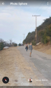
Tower/Construction surveillance camera. What do we really know? According to the PI/news, the camera(s) indicate MW's car drove northbound on the Topanga Tower Mwy at a time that correlates with the cellular data: number of occupants is unknown. Also, an unknown number of persons walked northbound to Rosas overlook; and, apparently, the same number of people walked southbound back to their cars. Unknown times, what they were wearing or carrying, etc. The issue I have is the microwave tower cameras appear to be very low-quality. I only spotted one, but suspect a second. At most their view covers a sliver of the Topanga Tower Mwy twice just below and to the north of their paved driveway; based on the camera(s) orientation, their primary focus is on internal/property coverage, and the dirt road would thus be on the edge of frame. Even IF the cameras are focused more heavily on the dirt road (used by MW's car), from their position high above that's over a 300 foot shot. No way it's picking up details. Car vs a bicycle, yes. People vs a group of cows, sure it can discern that. Also, at 0715, with the sun low in the east, it's likely MW's car (and the hikers) would have been in shadows.
911 call. What do we know about this? The reports are all over the place. From someone saying the screams included, "He's got a gun!' to, more realistically, a domestic dispute between a man and a woman. Mind you, there are no residences within earshot of Rosas overlook (except for the microwave tower). And it is unknown if the 911 caller was ever identified, interviewed, etc. Much of the disruption to brush I saw - possibly indicative of SAR activity in response to the 911 call - was located near the Topanga overlook and all along the edges, especially the northwest facing side, of Topanga Tower Mtwy (where it's paved and up to just before Rosas overlook). Were the screams from down in that area with thick almost impenetrable brush? That's no-mans land unless someone was catapulted in there. Was a helicopter brought out during the wee hours? Did it have/utilize thermal? What is known about the responding unit's findings? I'm not sanguine a police cruiser would drive down the dirt path to Rosas overlook - it's not safe for anything other than high-clearance vehicles, especially at 0100. A lot about this doesn't make sense. Calling in a helicopter with thermal at 0100 based on a 911 call that was apparently never verified (followed up on) and then finding nothing.
I'm only trying to stir the pot so as to press the issue. My views on this are probably not the same as everyone elses, and I think the truth only springs from everyone challenging one another. Critical in figuring this out is challenging others - the police, associates, etc - to look at this from a variety of perspectives. Why did MW (or his handset) spend SO much time on Saddle Peak Rd southeast of Topanga Overlook? About 35 min... How much searching has gone on here especially along the smaller trails that connect Saddle Peak Rd with Backbone (and it's tributaries)? If one is intent on driving out to Rosas (and destroying a BMW), then why fiddlefk around on Saddle Peak? Looking for what?