California WildFires 2017

DNA Solves
DNA Solves
DNA Solves
Dear Gardener1850,

Thank you for posting this. It's all so terrifying to see the tremendous force and speed of these fires.

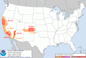
Chance of some rain this coming week:

From the (below) article:

"It's not going to be a lot unfortunately but it will mean a much higher relative humidity value," says Charles Bell, a meteorologist with the National Weather Service. "That's important because fires like dry air and they grow quickly. If we have higher relative humidity and the air is more moist, it helps to slow fire growth."

http://www.sfgate.com/bayarea/article/Northern-California-weather-rain-forecast-fire-12276057.php
 
This is all so heartbreaking to see.

I keep checking on forecasts for rain, water bombers and planes dropping fire retardants because I desperately, along with everyone else, want to find some hope and soon.

Being hundreds of miles away, I feel so helpless. All I can do is pray for the people there.

Reading about the firefighters and especially the heroic efforts of sheriffs and ordinary people are uplifting.

It truly amazes me to see the force of humanity at its finest.
 
It has to slow down soon right?
It can't just keep going with all these firefighters! :scared: :gaah:

Thanks once again. THIS time I made a note! :)

Not a problem, nice to have the answer for once! Or twice. :wink: :wave:
 
There will be a media conference this afternoon when Gov. Brown and Senators Feinstein and Harris visit Sonoma County:

"Governor Jerry Brown, along with U.S. Senators Dianne Feinstein and Kamala Harris will be in Sonoma County.

They are expected to travel to the areas affected by the fires, and hold a briefing. The three will meet with local leaders and emergency management officials, before they join a community meeting in Santa Rosa.

Santa Rosa firefighters, Sonoma County Board of Supervisors, Cal Fire, and other city officials will also be attending the community meeting.

The media availability is scheduled for 2 p.m. "


http://www.ktvu.com/news/governor-jerry-brown-senator-feinstein-to-visit-sonoma-county
 
Day 1 Fire Weather Outlook NWS Storm Prediction Center Norman OK 1158 AM CDT Sat Oct 14 2017 Valid 141700Z - 151200Z ...CRITICAL FIRE WEATHER AREA FOR PORTIONS OF NORTHERN CALIFORNIA... ...CRITICAL FIRE WEATHER AREA FOR PORTIONS OF SOUTHERN CALIFORNIA... ...


(O/T, snip CRITICAL FIRE WEATHER AREA FOR A SMALL PORTION OF THE LOWER COLORADO RIVER VALLEY... ...CRITICAL FIRE WEATHER AREA FOR PORTIONS OF SOUTH-CENTRAL AND SOUTHEASTERN COLORADO... A critical area has been introduced for the San Luis Valley and parts of southeastern CO where consensus of latest high resolution guidance suggests sustained west-northwesterly winds of 20-30 mph will likely combine with RH values of 10-15% and dry fuels. The elevated area across parts of the Four Corners region into south-central CO has also been expanded eastward into more of southeastern CO.)

No changes have been made to the ongoing critical area across parts of northern CA. 16Z surface observations show strong/gusty northerly to northeasterly winds are occurring across the parts of the Sacramento Valley and adjacent coastal ranges and Bay Hills along/north of San Francisco. RH values will continue to fall this morning and will likely become lowered into the 10-15% range by early this afternoon. While wind speeds are expected to slowly weaken through the rest of today across northern CA as the surface pressure gradient relaxes, there should still be a sufficient overlap of strong/gusty winds and critically reduced RH values over the next few hours to support the continuation of the critical area across this region. Across southern CA, critical fire weather conditions are ongoing as of 16Z across mainly the higher terrain of the coastal ranges/foothills to the north and northeast of Los Angeles. These critical conditions will likely continue through the day and spread towards the coast tonight as surface high pressure settles into the Great Basin and the pressure gradient strengthens across southern CA. The critical area has been removed from Santa Barbara County where wind speeds have lessened this morning, and are not expected to restrengthen through the remainder of the period. No changes have been made to the ongoing elevated/critical delineations across portions of the lower CO River Valley. See the previous discussion below for more information. ..Gleason.. 10/14/2017

http://www.spc.noaa.gov/products/fire_wx/fwdy1.html
 
Oct 14, 2017 Day 2 Fire Weather OutlookUpdated:*Sat Oct 14 17:51:02 UTC 2017

Day 2 Fire Weather Outlook NWS Storm Prediction Center Norman OK 1250 PM CDT Sat Oct 14 2017 Valid 151200Z - 161200Z ...CRITICAL FIRE WEATHER AREA FOR PORTIONS OF SOUTHERN CALIFORNIA... No changes have been made the ongoing elevated/critical areas for Day 2/Sunday across portions of southern CA and the lower CO River Valley. See the previous discussion below for more information on the fire weather threat across these regions. ..Gleason.. 10/14/2017 .PREV DISCUSSION... /ISSUED 0301 AM CDT Sat Oct 14 2017/ ...Synopsis... A weak upper ridge is expected to remain in place across much of the West on Sunday, as a strong upper trough moves quickly eastward from the Midwest into the eastern Great Lakes and Northeast. Some weakening of the surface ridge across the Great Basin is expected, though offshore flow is still expected to be sufficient for a fire weather threat across southern CA. ...Southern California... Critical fire weather conditions driven by moderate offshore flow are expected to be ongoing at the start of the period Sunday morning across portions of southern CA. Critical conditions are expected to persist into the afternoon, as RH values fall into the 5-15% range after poor overnight recovery and wind speeds remain at 15-25 mph with higher gusts. A gradual weakening of offshore flow is expected by late afternoon as the surface pressure gradient slowly decreases and critical conditions should begin to abate by Sunday evening, though RH recovery is again expected to be poor from Sunday night into Monday morning. ...Central/Northern California... Warm and very dry conditions are again expected across central/northern CA on Sunday, with minimum RH values of 10-15% expected across a large area. However, winds are expected to be rather light, resulting in a decreased fire weather threat compared to previous days. ...Portions of the Lower Colorado River Valley... Near-critical conditions may be ongoing across portions of the lower CO River Valley on Sunday morning. Winds are expected to decrease through the day, though elevated to locally critical conditions are expected to persist into the afternoon and an elevated delineation has been introduced to account for this threat. ...

http://www.spc.noaa.gov/products/fire_wx/fwdy2.html
 
Day 3-8 Fire Weather Outlook Issued on Oct 13, 2017Updated:*Fri Oct 13 21:44:03 UTC 2017

Day 3-8 Fire Weather Outlook NWS Storm Prediction Center Norman OK 0442 PM CDT Fri Oct 13 2017 Valid 151200Z - 211200Z An upper trough over the Upper Midwest will continue eastward on Day 3/Sunday as an upper ridge remains over the western CONUS. This upper ridge should deamplify somewhat from Day 4/Monday into Day 5/ Tuesday as a shortwave trough progresses across the Pacific Northwest, northern Rockies, and adjacent Canadian provinces. At the surface, an area of high pressure over much of the Great Basin is forecast to slowly weaken from Day 3/Sunday into Day 4/Monday. ...Day 3/Sunday - Day 4/Monday: Portions of Southern CA... Critical fire weather conditions will likely be ongoing across portions of southern CA early Sunday morning as a strong surface pressure gradient remains between the previously mentioned surface high across the Great Basin and an inverted trough off the southern CA coast. Strong/gusty offshore winds are expected overlap critically lowered RH values and dry/very dry fuels to support a critical threat. Therefore, have introduced a 70%/critical designation across parts of southern CA for Day 3/Sunday. The surface pressure gradient should weaken across southern CA from late Sunday afternoon into early Monday morning. Elevated fire weather conditions may persist where locally gusty winds combine with poor overnight RH recovery. But, the strength of surface winds will likely become too marginal by Day 4/Monday to warrant any probabilities for critical fire weather conditions. ..Gleason.. 10/13/2017

http://www.spc.noaa.gov/products/exper/fire_wx/
 
It is heartening to read about how the assistance for the firefighting airplanes are assembling. Here's an interesting article on a mobile set-up for air traffic control for the 300 operations daily of aerial fire planes:

http://sacramento.cbslocal.com/2017/10/10/california-wildfire-air-attack/

"Typically, there is no air traffic control team at McClellan and the pilots simply communicate with each other when they need to land and depart.

The Tower Tech team is scheduling 12 air tankers on a loop, loading fire retardant, making drops and coming back to load up again. But the guys are also handling private planes here on business.

“This is a very convenient airport for them to land at, as opposed to international,” Gall said.

All together, they’re averaging 300 operations a day.


McClellan broke a record yesterday by pumping more than 266,000 gallons of fire retardant. At this point, Tower Tech isn’t sure how long they will be based at McClellan, but on Wednesday they are setting up another operation in Oroville."
Is there any chance they could run out of retardant?[emoji120]

Sent from my SM-G930T using Tapatalk
 
(Not liking the word "Colorado" on the above reports.)
 
attachment.php

http://www.spc.noaa.gov/products/fire_wx/fwdy1.html
 

Attachments

  • day1otlk_fire.gif
    day1otlk_fire.gif
    25.5 KB · Views: 60
That body-cam rescue reminded me so much of Dante's Peak, when they were driving and you just see ash flying at the windshield. And then the fires out the side window. Freaky and terrifying.

So far most of the names they have released appear to be elderly and I feel as if that is going to continue when more names of the deceased come out.

So heartbreaking.
 
Never mind last comment. From the picture it's clearly the state. [emoji22]

Sent from my SM-G930T using Tapatalk

( Colorado Wildfires Map:
https://www.colorado.gov/pacific/dfpc/current-wildfires
Right now they are at 115 acres and 1000 acres, 2 fires, hopefully these can be contained.)

Back to you guys in CA...

Mother Nature has been cruel this year, to so many.

No words to describe the sad immensity of these fires. Positive thoughts to everyone.
 

Members online

Online statistics

Members online
151
Guests online
2,626
Total visitors
2,777

Forum statistics

Threads
603,329
Messages
18,155,046
Members
231,708
Latest member
centinel
Back
Top