
- Home
- Forums
- SPECIFIC CASE FORUMS
- More Case Discussion Forums
- Mickey Shunick
- Mickey Shunick General Discussion Threads
You are using an out of date browser. It may not display this or other websites correctly.
You should upgrade or use an alternative browser.
You should upgrade or use an alternative browser.
LA - Mickey Shunick, 21, Lafayette; 19 May 2012 - #23
- Thread starter beach
- Start date


- Status
- Not open for further replies.
saralsim
Well-Known Member
- Joined
- May 31, 2012
- Messages
- 161
- Reaction score
- 1,000
Not sure if this has been addressed, but I have seen several comments throughout the threads about the Google maps data being old. At the beginning of the year I saw a Google car (with CA plates) driving around my neighborhood with a camera installed on the roof - they were stopping and photographing up and down the streets. At the time I thought it was SO funny. I guess I'd never thought about how they actually got the "street view" images, but I never imagined that it could be someone's job to physically drive around the country shooting these photographs") .
.
The version of Google Earth that I'm using, shows Copyright 2012 on the images. Also, I have a friend that lives in the Saints streets area, and her house shows the car that she has now, which I believe is a 2011. Looking for a link now. JMO.
. The version of Google Earth that I'm using, shows Copyright 2012 on the images. Also, I have a friend that lives in the Saints streets area, and her house shows the car that she has now, which I believe is a 2011. Looking for a link now. JMO.
Also, I know Google guy is several years old but down on St. Landry on the corner of Henry, is a four door Z71 parked in the driveway on St. Landry side. Maybe check and see if the truck and owners still live there, still have the truck and if anything seems suspicious?
I do think she is a blur on the photo behind the hooptie in the St. Landry/Hooptie photo.
The back tire just jumps out at me. So, I think she made it down Landry to her usual left and towards Johnston. She was moving at a pretty good clip, she had to stop on purpose, maybe for a stop light?
I also -cannot get myself to leave that hospital alone...an empty hospital just seems so vast and kind of cut off from sight or suspect. It seems kind of cliche' like Whiskey Bay. Like out of a bad novel. But, I think we are dealing with an older demented/mentally ill person and not some perverted drunk oil rig guy. It needs looked at again.. Hospital rooms, laundry rooms, utility closets, basement?
Is that a coulee that runs underneath the hospital?
JurysOut
Just a person
- Joined
- Jun 2, 2011
- Messages
- 2,498
- Reaction score
- 1
Not sure if this has been addressed, but I have seen several comments throughout the threads about the Google maps data being old. At the beginning of the year I saw a Google car (with CA plates) driving around my neighborhood with a camera installed on the roof - they were stopping and photographing up and down the streets. At the time I thought it was SO funny. I guess I'd never thought about how they actually got the "street view" images, but I never imagined that it could be someone's job to physically drive around the country shooting these photographs
The version of Google Earth that I'm using, shows Copyright 2012 on the images. Also, I have a friend that lives in the Saints streets area, and her house shows the car that she has now, which I believe is a 2011. Looking for a link now. JMO.
Good to know!
Great video that shows the strength of Whiskey Bay. Sorry if it has been posted already.
[ame="http://www.youtube.com/watch?v=-JSrs88g4RA&feature=youtube_gdata_player"]Whiskey Bay Pilot Channel at I-10 Bridge - YouTube[/ame]
[ame="http://www.youtube.com/watch?v=-JSrs88g4RA&feature=youtube_gdata_player"]Whiskey Bay Pilot Channel at I-10 Bridge - YouTube[/ame]
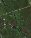
Maybe this map will give you an idea logistics wise (hoping the darn thing works right lol).So, it does run toward Butt La Rose then, ok. Thank you!
http://goo.gl/maps/B8tN
Maybe this map will give you an idea logistics wise (hoping the darn thing works right lol).
http://goo.gl/maps/B8tN
I was trying to figure out how to post a map, good job
Does anyone know anything else about that fire and burglary? Like maybe what kind of tools were stolen.
Which Fire ? The one in breaux bridge at the mack dealership?
tezi
Proud member of WS since 2000.
- Joined
- Aug 13, 2003
- Messages
- 5,670
- Reaction score
- 2,367
Does anyone know anything else about that fire and burglary? Like maybe what kind of tools were stolen.
At least two pressure washers.
IMO, JMO, :moo:, and all other disclaimers.
bessie
Verified Insider
- Joined
- Aug 19, 2008
- Messages
- 31,771
- Reaction score
- 1,693
Not only alligators but a number of other predators and scavengers.Alligators, people. If there is a body in a swamp, it doesn't come out.
Which Fire ? The one in breaux bridge at the mack dealership?
Fire in Lafayette night before last, 3 am. A tool shop on University was burned down. Initial reports have said two pressure washers were taken, along with the dash vent covers and tail lights from the pickup that was parked there. A total loss of the business and suspected arson.
mamamia54
Inactive
Maybe this map will give you an idea logistics wise (hoping the darn thing works right lol).
http://goo.gl/maps/B8tN
Yes, that did help. Thank you. As much as I've looked at the map I didn't see exactly where Butt La Rose actually was. So, this map may help to see where a body possibly could get hung up, depending on how swiftly the current moves, and any rocks or obstacles in the water. I'm not convinced about that video showing the swiftness of water on that date, could have been after the flooding so didn't really want to go with the video.
Attachments
mommyof6
Life is all about choices
- Joined
- Aug 22, 2008
- Messages
- 316
- Reaction score
- 2
I'm trying to catch up on all of the threads but it's almost impossible trying to read and being a taxi driver for 6 kids. Anyway, I don't know if this has already been discussed recently so sorry if it has...
I know the new team of searchers aren't speaking to the media, but has anyone seen where they are searching? And I never did see if TES was back in town. Just being curious. Hope everyone has a great day!
I know the new team of searchers aren't speaking to the media, but has anyone seen where they are searching? And I never did see if TES was back in town. Just being curious. Hope everyone has a great day!
HouDat
Prominent Member
- Joined
- May 27, 2012
- Messages
- 684
- Reaction score
- 1,477
Does anyone know anything else about that fire and burglary? Like maybe what kind of tools were stolen.
If you watch the video (linked earlier), the interviewee discusses that subject.
Yes, that did help. Thank you. As much as I've looked at the map I didn't see exactly where Butt La Rose actually was. So, this map may help to see where a body possibly could get hung up, depending on how swiftly the current moves, and any rocks or obsticles in the water. I'm not convinced about that video showing the swiftness of water on that date, could have been after the flooding so didn't really want to go with the video.
That river alwys has a good current but I do beleave that video was done during the flooding. If you ever go over the Mississippi river, take a look at that current, it is comparable to that all the time
liltexans
Retired WS Staff
- Joined
- Jan 4, 2011
- Messages
- 13,451
- Reaction score
- 25,912
I'm trying to catch up on all of the threads but it's almost impossible trying to read and being a taxi driver for 6 kids. Anyway, I don't know if this has already been discussed recently so sorry if it has...
I know the new team of searchers aren't speaking to the media, but has anyone seen where they are searching? And I never did see if TES was back in town. Just being curious. Hope everyone has a great day!
I'm not a local so I can't provide any answers on if the new K-9 search team has been seen anywhere by locals, but there have been no published reports of where they are searching.
TES was planning to return to Lafayette yesterday, but they got called away suddenly to assist with finding a drowning victim in another state. I believe TES will return when they are able to if Mickey hasn't been found.
mamamia54
Inactive
If I can get away from everything tomorrow, and if no one else has done it, and if the area isnt roped off, I will go to WB exit tomorrow and take some pics and video. I only live 15 minutes from it
Thanks that would help. I'm just looking a little closer to the waters edge where I have mapped, and I can see a number of places that seem to stick out further into the water than others. I think maybe what I will do today, is to mark those places on one map. In a few places it looks like camps down there too where the edge seems to jut out. So many people seem to think that she may be in there, and then also the alligator factor, it just may be impossible to find her.
paris_paris
Well-Known Member
- Joined
- May 2, 2009
- Messages
- 2,503
- Reaction score
- 532
Not sure if this has been addressed, but I have seen several comments throughout the threads about the Google maps data being old. At the beginning of the year I saw a Google car (with CA plates) driving around my neighborhood with a camera installed on the roof - they were stopping and photographing up and down the streets. At the time I thought it was SO funny. I guess I'd never thought about how they actually got the "street view" images, but I never imagined that it could be someone's job to physically drive around the country shooting these photographs
The version of Google Earth that I'm using, shows Copyright 2012 on the images. Also, I have a friend that lives in the Saints streets area, and her house shows the car that she has now, which I believe is a 2011. Looking for a link now. JMO.
Google earth shows my old Blazer parked in my field for sale. I sold it 4 years ago. At my sister's house across the province, the image is 4 years old. About 8 months ago her husband saw the Google car go by and he raised his beer, but the image is still the 4 year old one. They are constantly updating, but slowly. There is an expensive program you can get that will provide the date to you.
- Status
- Not open for further replies.
DNASolves
Members online
Total: 3,567 (members: 122, guests: 3,445)
Online statistics
- Members online
- 122
- Guests online
- 3,445
- Total visitors
- 3,567
Totals may include hidden visitors.