MN MN - Bryce Borca, 23, college student, seen at 2AM, search focused near Minnesota River, Eagan, 30 Oct 2022

DNA Solves
DNA Solves
DNA Solves
Due to the snow melt, there is lots of flooding happening and I don’t think searches are possible right now. Fort Snelling State Park (which is the swampy forested area that abuts the industrial strip where Bryce went missing) is currently closed due to the high waters:


I’m hoping the flood waters don’t disrupt any remains that are (likely) out there. Really want his family to have closure.
The area where he was last heard from is a good 1/2+ mile to the Minnesota River. Level is not high enough to reach there - would be an unheard of flood. Ft Snelling is closed because the river is close to the well-used park; there's a swimming beach there, paved trails, etc. Fort itself is high, not flooded.

This, of course, is not to say he didn't wander that 1/2 mile to the river, although the river was searched. River level is not going to affect the holding ponds near where he disappeared. This is run-off. Swampy area is still swampy as a left-over from snow and recent rain.
 
Allow me to explain Ft. Snelling State Park. There are about 5 areas that are totally different.

First, there's Historic Ft Snelling. Tourist attraction. Fort. It's on a high hill. No danger of flooding.

Second, there's Ft Snelling State Park where everyone goes. Paved trails along the Mississippi River, picnic benches, swim beach, park office. Paved trail goes to Minnehaha Park. Definitely flooded and closed.

Next is the Minnesota River part of Ft Snelling Park. Actually, this is where the cities of Bloomington, Burnsville, Eagan, and DNR land come together. Paved MN River Greenway is on the south side of the Minnesota River and partially on the north side (unfinished). Trail is from I-35 to I-77. Mountain bike trail also on the north side. You can bet 100% this is flooded and closed.

Next is the almost no man's land north of I-77. Unpaved trails on both sides of the Minnesota River. North side unpaved trail ends in Bloomington, south unpaved trail at Mendota (mostly). The unpaved mostly mountain bike trail, although next to the Minnesota River, is not very near where he disappeared. It' would be a walk through 1/2 mile+ swampy area with tall weeds from Highway 13 where his last call came from. Plans for the south side include a paved trail to connect to the I-77 bike bridge, but so far this trail ends at a nice parking lot at Lone Oak Rd, does not connect south, not connected to the area where he disappeared. Possible he could have found the paved trail but not likely. Paved trail there goes across 494 and/or connects to the Big Rivers Trail. Doubtful he made it that far. Area definitely flooded by the river but not along Highway 13 where he disappeared.

Finally, north of where Bryce disappeared are holding ponds and Gun Club Lake. About a hundred years or more ago Gun Club was a prime area for elite (wealthy) fishing. No more. Homeless, etc. often hang-out there. There are warnings to fishermen to be careful.

If he was in the Minnesota River (connects at Ft Snelling to the Mississippi River), his body, with flooding, would be perhaps many miles downstream. Most likely, as things dry out, searches are going to be on land near where he disappeared, perhaps holding ponds again. Everyone is mystified as to where to search. It's very strange he was not found immediately.
 

Could this be him? Not sure if he would have made it to this area but throwing it out there.
That's a long way, but it's also been a long time, plus flooding. Possible. If this is him, he must have made it to the Minnesota River after all. MN River drains into the Mississippi River. Minnesota River was relatively low when he disappeared. Wonder how he wasn't found.
 
Last edited:
That's a long way, but it's also been a long time, plus flooding. Possible. If this is him, he must have made it to the Minnesota River after all. MN River drains into the Mississippi River. Minnesota River was relatively low when he disappeared. Wonder how he wasn't found.
I thought their focus was on the quarry or retention pond. I thought the river was ruled out but I guess nothing can be ruled out until he is found.
 
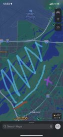
I drove over there today to see how things look and unfortunately, there is quite a bit of flooding. My sister and I searched (on our own) many hours last fall. I liked to park in the lot under the Cedar Ave bridge. That whole area is currently blocked off from the point of the railroad tracks along that road. It’s part of Ft Snelling park so it makes sense. I scribbled a chicken scratch map. The red line is where they have it barricaded off— can’t go north of that. The purple X is approx his last known location. The blue is flooding. When we were down there before, the water was all within that skinny little river. Then between the river and the railroad tracks (that run just behind the industrial buildings) there was a huge section of marsh with dry plant stalks sticking out. It was not possible to walk that in shoes because the water was about ankle to calf deep in some parts. Tall rain boots would have been fine. Now though, I would say it looks at least waist deep. You can’t quite tell what is river and what isn’t because the whole area is just water. I can see why they don’t want people back there right now. Very dangerous if you step in the wrong spot, plus very cold. Definitely some spots are dry enough for searching (near the quarry ponds and a bit of park between the flooding and tracks). Oof though, it just made me sad to see.


0736BC5A-F446-47DD-846D-0FF7FC744117.jpeg
 
I drove over there today to see how things look and unfortunately, there is quite a bit of flooding. My sister and I searched (on our own) many hours last fall. I liked to park in the lot under the Cedar Ave bridge. That whole area is currently blocked off from the point of the railroad tracks along that road. It’s part of Ft Snelling park so it makes sense. I scribbled a chicken scratch map. The red line is where they have it barricaded off— can’t go north of that. The purple X is approx his last known location. The blue is flooding. When we were down there before, the water was all within that skinny little river. Then between the river and the railroad tracks (that run just behind the industrial buildings) there was a huge section of marsh with dry plant stalks sticking out. It was not possible to walk that in shoes because the water was about ankle to calf deep in some parts. Tall rain boots would have been fine. Now though, I would say it looks at least waist deep. You can’t quite tell what is river and what isn’t because the whole area is just water. I can see why they don’t want people back there right now. Very dangerous if you step in the wrong spot, plus very cold. Definitely some spots are dry enough for searching (near the quarry ponds and a bit of park between the flooding and tracks). Oof though, it just made me sad to see.


View attachment 417203
Yes. It definitely is flooded under the Cedar Bridge, but this is not where he disappeared. He was higher up on Highway 13 near Yankee Doodle Rd. That area is not flooded. This is way off from the Cedar Bridge. I did a GPS from Yankee Doodle and Highway 13 straight to the river. The distance is 1.1 miles through swamp and tall weeds. If you walked to the Cedar Bridge, the distance is 2 miles. The Eagan police/family actually walked the entire tracks north from Cedar when he first disappeared. We encountered them as they had just left Nichols Rd. He could have walked the tracks to very near the Cedar Bridge, but they found no evidence. No train through there at those hours either.
 
Last edited:
Yes. It definitely is flooded under the Cedar Bridge, but this is not where he disappeared. He was higher up on Highway 13 near Yankee Doodle Rd. That area is not flooded. This is way off from the Cedar Bridge. I did a GPS from Yankee Doodle and Highway 13 straight to the river. The distance is 1.1 miles through swamp and tall weeds. If you walked to the Cedar Bridge, the distance is 2 miles. The Eagan police/family actually walked the entire tracks north from Cedar when he first disappeared. We encountered them as they had just left Nichols Rd. He could have walked the tracks to very near the Cedar Bridge, but they found no evidence. No train through there at those hours either.
The wet swampy areas behind the industrial buildings are not from the river flooding but from snow melt and last week's rain. It would not be smart nor safe to walk from the buildings to the flooded river. Checking out the area, you can understand why the Eagan police to not want to search just yet.
 
Yes. It definitely is flooded under the Cedar Bridge, but this is not where he disappeared. He was higher up on Highway 13 near Yankee Doodle Rd. That area is not flooded. This is way off from the Cedar Bridge. I did a GPS from Yankee Doodle and Highway 13 straight to the river. The distance is 1.1 miles through swamp and tall weeds. If you walked to the Cedar Bridge, the distance is 2 miles. The Eagan police/family actually walked the entire tracks north from Cedar when he first disappeared. We encountered them as they had just left Nichols Rd. He could have walked the tracks to very near the Cedar Bridge, but they found no evidence. No train through there at those hours either.

Yes right. I don’t disagree with anything you are saying :) I’m just saying that since he hasn’t been found, he might not be in that area he was last heard from. Of course there are those tricky quarry ponds which are a real possibility. I hope they figure out a way to drain them. Other than that, it’s also possible he trudged far away in just about any direction. He could have made it a few miles and be way outside where the initial search zone was.
 
Hi all - I finally made a WS account as I've been following this thread since Bryce went missing.
It hurts my heart that Bryce still hasn't been found and there continues to be so little coverage.
Does anyone understand the K9 maps well enough to explain them? I get thrown off with the points and the marks. I'm not sure what significance they have.
Prior to flooding, I went behind Essendant and trudged my way to the ponds. I didn't see anyone nearby. LE seems to be hyper fixated on the ponds/pits. Every time I go down there, I'm baffled by the amount of concrete buildings, semi trucks, supply piles, bright lighting, brush and the set of train tracks Bryce would have had to intentionally pass by to get to the pond. I always go back to thinking something, anything, would have had to reorient him at least once... right?
I echo what everyone is feeling, the uneasiness of not having found him the day of the search...
Part of me believes he isn't in the water and that we've been waiting for the thaw to only be met with more questions.
I want to try to get his name back out there again, thinking I'll do another video reminding people of his story. Not sure what other information I could include as everything has been so tight lipped, family/friends/LE. Ugh. But I do appreciate the conversation we're able to have here. Ideas?
 
Yes right. I don’t disagree with anything you are saying :) I’m just saying that since he hasn’t been found, he might not be in that area he was last heard from. Of course there are those tricky quarry ponds which are a real possibility. I hope they figure out a way to drain them. Other than that, it’s also possible he trudged far away in just about any direction. He could have made it a few miles and be way outside where the initial search zone was.
Just don't understand how an intoxicated person could keep walking and make either the trail at Lone Oak, Gun Club Lake, or the Minnesota River. Most of us have had a bit too much in our lifetime, and from my perspective, it seems he would sit down, lie down, fall asleep, or stumble into something closer to where he disappeared - assuming he disappeared in the state park. I keep thinking, what if he's not found?
 
Hi all - I finally made a WS account as I've been following this thread since Bryce went missing.
It hurts my heart that Bryce still hasn't been found and there continues to be so little coverage.
Does anyone understand the K9 maps well enough to explain them? I get thrown off with the points and the marks. I'm not sure what significance they have.
Prior to flooding, I went behind Essendant and trudged my way to the ponds. I didn't see anyone nearby. LE seems to be hyper fixated on the ponds/pits. Every time I go down there, I'm baffled by the amount of concrete buildings, semi trucks, supply piles, bright lighting, brush and the set of train tracks Bryce would have had to intentionally pass by to get to the pond. I always go back to thinking something, anything, would have had to reorient him at least once... right?
I echo what everyone is feeling, the uneasiness of not having found him the day of the search...
Part of me believes he isn't in the water and that we've been waiting for the thaw to only be met with more questions.
I want to try to get his name back out there again, thinking I'll do another video reminding people of his story. Not sure what other information I could include as everything has been so tight lipped, family/friends/LE. Ugh. But I do appreciate the conversation we're able to have here. Ideas?
Agree with all you've said, especially that he should have been found the day of the massive people search. If the thaw doesn't reveal anything, then what? I keep wondering if the reward is the family thinking he may be elsewhere, although money hasn't enticed any ideas. Guess Eagan PD will search until there's nothing more left to search. Other possibilities include massive trash bins or picked up by a vehicle.
 
My own opinion. I still think there is something going on that none of us know about and the family is keeping quiet about. Not sure exactly what that is. Since the beginning with so little info, calling off the search the first day and sending half the people home, no public appearances by family (nothing released about who the family even is), and rare updates since. Total opposite for Madeline Kingsbury in Winona…which is likely a POI and criminal case.
Also the $30K reward months later baffles me. For a family that well off, is that a reasonable reward to find your son? And coming AFTER they set up the foundation in his honor/memory? And with so many people in the community offering to help over months, and being turned away? I don’t get it.
I drove by Essendant and the holding ponds yesterday (Saturday) around noon. Zero cars or activity there, which was the hub last fall and full of cars and people searching.
So the snow is melted, and nothing going on? Is anyone even trying to look for Bryce anymore? Has anyone else seen any activity or searchers in that area recently?
Just devastating and confusing.
 
Last edited:
My own opinion. I still think there is something going on that none of us know about and the family is keeping quiet about. Not sure exactly what that is. Since the beginning with so little info, calling off the search the first day and sending half the people home, no public appearances by family (nothing released about who the family even is), and rare updates since. Total opposite for Madeline Kingsbury in Winona…which is likely a POI and criminal case.
Also the $30K reward months later baffles me. For a family that well off, is that a reasonable reward to find your son? And coming AFTER they set up the foundation in his honor/memory? And with so many people in the community offering to help over months, and being turned away? I don’t get it.
I drove by Essendant and the holding ponds yesterday (Saturday) around noon. Zero cars or activity there, which was the hub last fall and full of cars and people searching.
So the snow is melted, and nothing going on? Is anyone even trying to look for Bryce anymore? Has anyone else seen any activity or searchers in that area recently?
Just devastating and confusing.
If this was my child, info would be all over: news, photos, updates from family, interviews with family and friends (especially "friends" he was with before he disappeared). Does anyone know names of individuals who were with him prior to his disappearance? And, why aren't searchers needed? No reason was given.

Rumor is the family is well-off so I wonder about reasons behind the reward as well as the reward amount. Maybe some of us are being sinister, but such odd behavior increases this feeling. Does the family read posts? Do they realize posters ideas? Are they still totally dependent on the Eagan police to find him? Have they hired outside resources?
 
The number of “young man last seen walking away after drinking” who end up found in water is astonishing.
Super late at night, wasted, cold and walking along swamps confused is a deadly combination, all it really takes is a stumble.

Very reminiscent of the Tyler Davis case, hoping for answers so both of their families can rest and grieve properly :(
Jmo
 

Staff online

Members online

Online statistics

Members online
159
Guests online
2,769
Total visitors
2,928

Forum statistics

Threads
602,873
Messages
18,148,109
Members
231,564
Latest member
onlyimagine
Back
Top