So this is important. The documented sighting at the gas station in Stagecoach somehow has an incorrect clock time. If NHP notes them on their traffic cam on Highway 95 near Hawthorne,NV at 5:30 pm then they were in Stagecoach more like 2:30 pm.
So documented sighting by NHP at 5:30 pm. No pings in Tonopah, NV where there clearly is cell service, but evidently not any CCTV footage. Hawthorne to Tonopah should be less than 2 hours, and 7:30 pm is half an hour after sunset, but not full-on dark.
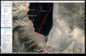
The time of their last ping in the area of the intersection of Highway 6 and Highway 95 (known as Coaldale area) hasnt been release, as far as I can tell, so we can't tell what kind of progress their phones, watches, ipad, etc were making.
Highway 95 is very flat in that area, as you can tell from GH's video. As he said "there's nowhere to get lost". This area is also well-traveled by passenger vehicles as well as long-haul truckers. Many of those truckers will be driving east along Highway 6 from the Bishop, CA area to turn onto Highway 95 at that Coaldale intersection, both to to north towards northern Nevada, Idaho and to go east towards Utah.
It doesn't seem that there is any evidence of a collision at that intersection that would render their rig inoperable. I am quite sure there is cell service all along Highway 95. I have Verizon, which is really the best in this area and farther west along the eastern Sierras and northern Nevada-Tahoe region. Don't know about T-mobile in this area, but Highway 95 is a major N-S route in Nevada and would likely have decent coverage there.
GH mentions Dyer, NV, a tiny farming hamlet of 320 people which is 35 miles SW of the Coaldale intersection, on a couple of paved back roads off of Highway 6. This doesn't make any sense other than perhaps it is technically the closed "inhabited" area from the Coaldale intersection. They'd have no reason to go there at all, IMHO.
One thing that does occur to me is that their rig must be pretty long, with the attached toad. People really love to speed along Highway 95 and they might have run across someone really impatient to pass them who got pissed off and wanted to run them off the road or something. Except their large white rig should have been easily visible for miles in that open desert region. It's some ways off the road until you get to some hills you could even hide a rig like that in.
There also have to have been at least 2 other people involved in their disappearance:
One person to drive their rig (and them) out of sight
One person to drive his own vehicle away from the scene.
My feeling right now is that Highway 6 and it's offshoots should be very thoroughly searched. I know there is a Caltrans camera at the Calfornia Agricultural Inspection Station in Benton ( aka: The bug station). It would easily pick up their large rig if it was taken into California.
https://cwwp2.dot.ca.gov/vm/loc/d9/us6stateline1.htm