
You are using an out of date browser. It may not display this or other websites correctly.
You should upgrade or use an alternative browser.
You should upgrade or use an alternative browser.
OH - Pike County: 8 people from one family dead as police hunt for killer(s) #11
- Thread starter tlcya
- Start date


- Status
- Not open for further replies.
I think the big long barn is on one of those parcels owned by CRsr ... they're all adjoining properties ... did anyone find out the build date for that big long barn? It looks nice, much nicer than the trailers they lived in anyway. Makes sense that it could house a pretty big pot growing operation.

2014 I believe. However that is the one I was talking about that isn't on CR .35 of an acre there. Neither is the trailer FR lived in. I posted a picture from auditor map a while back. Let me see if I can find it.
I found 3 people assoicated with this property or area 799-1084. 2 being family via public court records. Haven't had the time to check more though. And yes Danya is awesome.
Aww Thank you
I found 3 people assoicated with this property or area 799-1084. 2 being family via public court records. Haven't had the time to check more though. And yes Danya is awesome.
She was asking about the Camp Creek property I think. 4740 Camp Creek. I believe only one name shows up for that. Easy to find though even if you search white pages or google.
Aww Thank you
You are welcome, your property searches and awesome explaining of them have been very helpful. Thank you.
2014 I believe. However that is the one I was talking about that isn't on CR .35 of an acre there. Neither is the trailer FR lived in. I posted a picture from auditor map a while back. Let me see if I can find it.
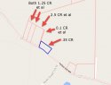
I'm pretty sure the big long barn is on one of the CR et al properties, see detailed parcel map below:
Attachments
rsd1200
Well-Known Member
- Joined
- Apr 25, 2016
- Messages
- 11,477
- Reaction score
- 30,744
I think that's true as well. I have even thought that the murderers, and what was discovered after the murders were committed, may not be related at all.Yes, it's all DeWine-speak, but I'm wondering if "convictions" wasn't a slip of the tongue.
If so, it wouldn't appear be a major revelation as it seems likely there was more than one perp, IMO.
DeWine has a lot riding on this case and he doesn't appear to be giving himself much room in the event it goes unsolved.
I'm thinking we'll (eventually) see a number of arrests, including some that will not be directly related to the murders.
Or I'm totally wrong. :rollercoaster:
first time posting...you guys have amazing minds to process all this info....as for the barn is their building permit info on the assessors or treasurer sites...I'm looking to buy a home and I check possibilities through those sites to see damage repairs and tax amount
You are correct as far as the acreage and parcels go. However you need the actual land image to see where the things are. .35 acre is not big enough for Barn, garage, FR trailer and CR trailer.
The bit outlined in blue on my map is the 0.35 acre parcel ... the adjoining ones to the left are all owned by CRsr et al ... I don't know how to do the aerial view overlay you did there, but if you dragged your map a bit to the right, all those parcels would be revealed, and the big long barn is definitely on one of them.
I was just going to reply to you. I had typed something on phone and lost it.
Most of the acreage was not one of the 4 crime scenes.
3122 Union Hill - DR lived - owned by only CR - 6 acres + 2 acre lot next to it - Scioto County
1084 Left Fork - KR lived - owned by CR et al - 6 acres
4077 Union Hill - .35 acre owned by Only CR and where CR and FR lived. Plus the other 4 parcels there that are owned by CR et al are .10 + 2.5 + 1.25 + 1.25 for a total of 5.45 acres at the 4077 crime scene.
The other acreage on Left Fork is owned by CR et al in 3 parcels and not a crime scene. The three parcels are 7 acres, 8 acres and 40 acres. They are considered the 799 Left Fork properties.
Then there is a lone property owned by CR only that is 1.9 acres on Camp Creek Road. Not a crime scene. No one talks about this one....
So CR himself only owned 10.25 acres with the majority of it the 8 acres he bought In March 2016 for $120k The rest is owned by CR et al and the bulk of it at 799 Left Fork. Which is where I think the 5 search warrant was.
Thank you dayna769 for the post....very insightful as IMO he (CR Sr) didn't have much land really to speak of and even the CR et al not much either and what is there probably isn't worth much, more than likely.
The bit outlined in blue on my map is the 0.35 acre parcel ... the adjoining ones to the left are all owned by CRsr et al ... I don't know how to do the aerial view overlay you did there, but if you dragged your map a bit to the right, all those parcels would be revealed, and the big long barn is definitely on one of them.
Yeah I know. I was showing you who owned the land they are living on. The land is outlined in blue and their name is on the parcel. I know CR has 5.45 acres total there, but look closely at the blue lines in my photo. The part where CR lives is only .35 the parcels next to that belong to him but barn and trailers aren't on those parcels.
Thank you dayna769 for the post....very insightful as IMO he (CR Sr) didn't have much land really to speak of and even the CR et al not much either and what is there probably isn't worth much, more than likely.
You're welcome
Oh duh, sorry, it's late, I should go to bed, I can see the map clearly now. :facepalm: That long barn is on Everett Farmer's land for sure. That's a real head scratcher. I'll check back in the morning when I'm fresh. My apologies, danya769.You are correct as far as the acreage and parcels go. However you need the actual land image to see where the things are. .35 acre is not big enough for Barn, garage, FR trailer and CR trailer.
rsd1200
Well-Known Member
- Joined
- Apr 25, 2016
- Messages
- 11,477
- Reaction score
- 30,744
I agree this seems more than routine to me. I didn't think about those tow fees either. I don't think there will be storage fees though. Pike County has their own impound lot. I found it on the sheriffs site. I don't see them seizing evidence and putting it on property the public can access.
The way that cars are rebuilt from a Salvage Title to Rebuilt Salvage Title is no small matter these days. If they were able to do this with stolen parts then it would take someone assisting them in the Dept. of Motor Vehicles. I dropped my m/c and it was deemed "totaled". I was the only owner of the bike. I bought it new. I wanted to keep it so I "bought" it back from the insurance company. The bike technically never left my hands and all the labor was done ourselves (had to submit a notarized statement say so). However, each and every part had to have a receipt and if a used part was purchased via a person (not a company/new part), I had to submit a notarized statement for that part (s). I had to have receipts for each and every part that went on that bike and VIN #s had to be submitted if any major parts (engine) had to be replaced. It is not just something you slap together and get a stamp of approval from the DOT. It's a major ordeal and lots of vehicles have to be resubmitted over and over. I had to resubmit. They do this b/c of the car theft/parts ring.
- Status
- Not open for further replies.
DNASolves
Online statistics
- Members online
- 147
- Guests online
- 1,851
- Total visitors
- 1,998
Totals may include hidden visitors.