Wondergirl
Well-Known Member
- Joined
- May 10, 2010
- Messages
- 9,658
- Reaction score
- 2,474
okay. finally. I finally feel like I made a bit of progress.
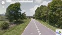
Anyone who can take a google walk-about, I implore you to drop the orange man somewhere close to the Old Sanders RD turn-off from the parkway, and follow along.
I want to know what Firetower RD. is used for. It looks like a police/tow/emergency service access road. It also looks like it could be used for atving/biking etc.
It cuts perpendicular to both the parkway and Old Sanders Rd. almost at the location of Amber's recovery.
Also, stand on the bridge, and swing around 360 degrees and look in all directions and tell me what you see.
Important to NOTE - The directions from Time Warner to the recover location are for the purposes of analyzing one potential route that Amber took. It's somewhere to start.
https://maps.google.com/maps?saddr=...E30AiTEhuCQxPyjQzA&oq=time+wa&mra=ls&t=m&z=15