Hopefully it will not be allowed .I hope I've linked this correctly - apologies if not.
I understand this completely, I really do. But surely that's going to be a horrific way to remember him
Jay Slater's grieving mother shares heartbreaking last request

You are using an out of date browser. It may not display this or other websites correctly.
You should upgrade or use an alternative browser.
You should upgrade or use an alternative browser.
Found Deceased Spain - Jay Slater, 19, missing on holiday in Tenerife, 17 June 2024 #5
- Thread starter Starship88
- Start date


I SO wish they hadn't chosen to photograph and publish these messages. I know they're in a public place but please - give them some respect and stop using their gfrief to sell newspapers.So incredibly heartbreaking. Someone's baby.
I agree. I didn't read them, It feels really intrusive to me ,I SO wish they hadn't chosen to photograph and publish these messages. I know they're in a public place but please - give them some respect and stop using their gfrief to sell newspapers.
Dotta
Well-Known Member
- Joined
- Jan 23, 2021
- Messages
- 11,274
- Reaction score
- 69,282
I SO wish they hadn't chosen to photograph and publish these messages. I know they're in a public place but please - give them some respect and stop using their gfrief to sell newspapers.
At least these are
Words of Love
and not
words of hate, contempt, jeering and vitriol
that surrounded this tragedy.
And with these
Loving Tributes
the public should say farewell to Jay Slater.
JMO
The public can say goodbye in their own words, not in the heartbroken words of grieving family members - personal loving thoughts from a mother and father's hearts, just desperate to see and talk to to their son one more time; from a stricken brother to the one he's lost.At least these are
Words of Love
and not
words of hate, contempt, jeering and vitriol
that surrounded this tragedy.
And with these
Loving Tributes
the public should say farewell to Jay Slat
JMO
But.... JMO
Last edited:
Dotta
Well-Known Member
- Joined
- Jan 23, 2021
- Messages
- 11,274
- Reaction score
- 69,282
The public can say goodbye in their own words, not in the heartbroken words of grieving family members - personal loving thoughts from a mother and father's hearts to their son; from a stricken brother to the one he's lost.
But.... JMO
If you visit a cemetery to pay respect
Do you not read loving inscriptions on graves you pass?
I do.
And feel humbled to see so much Love.
Why is it that some don't object to conspiracies, contempt and vitriol
but
feel offended when see words of Love?
I don't think the Family object.
They want to show their Love for their son/brother to the whole world.
As we saw it in all reports.
And all words they ever uttered.
JMO
Last edited:
imstilla.grandma
Believer of Miracles
- Joined
- Jul 7, 2018
- Messages
- 32,260
- Reaction score
- 218,593
"There are a number of complex issues that need to be addressed before he can finally be flown home to the UK.
"But the plan is for his family to be on the same flight. They want to bring him home."
Jay's family expect his body to be repatriated by the start of next week.
A second post-mortem may be carried out by authorities back in the UK, before a funeral for the teenager takes place

 www.lbc.co.uk
"But the plan is for his family to be on the same flight. They want to bring him home."
Jay's family expect his body to be repatriated by the start of next week.
A second post-mortem may be carried out by authorities back in the UK, before a funeral for the teenager takes place
Jay Slater’s body to be flown back to the UK as second post-mortem may take place
Jay Slater’s body will be flown back to the UK next week after Spanish authorities concluded their investigation into the teenager’s death.
www.lbc.co.uk
acutename
Well-Known Member
- Joined
- Jan 18, 2019
- Messages
- 3,708
- Reaction score
- 25,863
she would recognize his clothing and she may need to see the shocking view to know that he is truly gone IMOMy brother died of a heart attack on mainland Spain . He was in a temperature controlled environment before being flown home 18 days later . After requesting an open coffin , my SIL was advised STRONGLY not to see my Bro . Although heartbroken she did heed these warnings thankfully . I'd like to add there was a strong odour from the closed coffin .
Jay was in the elements with high temps. Last memories shouldn't be shocking , awful or hurtful . It's a memory that will last forever.
carbuncle69
Well-Known Member
- Joined
- Dec 28, 2016
- Messages
- 49
- Reaction score
- 263
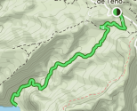
Excellent links. There's a difference between the two routes that I think might explain how and where the poor lad met his death. This is from your first link (all trails) annotated using my worlds beating MS Paint skills ;-)Think you may be right with your blue route, looks like he may have strayed onto the "challenging" Barranco trail
There's an account by some people who made the descent here -> Barranco Juan López - Teno Mountains - Tenerife | SiebenInseln- with photos, which show that, even if Jay had made it down to the sea, there's nothing there other than a lonely little rocky beach!

Point A is Jays last known location.
B is the end of the good, wide track.
In the second link they went a different way. Coming up via the Carizalles mountain track (C) to the ridge forming the north side of the Baranco Juan Lopez, over the saddle (D) and back down to the end of the track we know Jay was on (B).

I can't help but think that if I was in Jays shoes, the trail comes to an end, what would I do. If you look on Google Earth there's a building at point D. Buildings usually means access tracks. Its on the South side of the ridge so may well have been visible. There's also a faint trail visible between B and D. So it's possible, even likely, that Jay reached the end of the track and headed up rather than down. If so there's a couple of ravines/re-entrants he may have fell down, marked in blue on the following:

As I said, academic now, the important people already know. But it will be interesting to see where the new search party the family bought in are looking, presumably for signs of foul play (not that I expect any will be found).
Attachments
Grouse
Well-Known Member
- Joined
- Dec 2, 2020
- Messages
- 1,200
- Reaction score
- 6,665
Excellent links. There's a difference between the two routes that I think might explain how and where the poor lad met his death. This is from your first link (all trails) annotated using my worlds beating MS Paint skills ;-)
View attachment 518533
Point A is Jays last known location.
B is the end of the good, wide track.
In the second link they went a different way. Coming up via the Carizalles mountain track (C) to the ridge forming the north side of the Baranco Juan Lopez, over the saddle (D) and back down to the end of the track we know Jay was on (B).
View attachment 518530
I can't help but think that if I was in Jays shoes, the trail comes to an end, what would I do. If you look on Google Earth there's a building at point D. Buildings usually means access tracks. Its on the South side of the ridge so may well have been visible. There's also a faint trail visible between B and D. So it's possible, even likely, that Jay reached the end of the track and headed up rather than down. If so there's a couple of ravines/re-entrants he may have fell down, marked in blue on the following:
View attachment 518532
As I said, academic now, the important people already know. But it will be interesting to see where the new search party the family bought in are looking, presumably for signs of foul play (not that I expect any will be found).
Yeah, interesting and quite possible. Probably academic now as you say but (like you I think) I do like like to get a feel for locations as well, to try to gain a bit of an understanding why things have gone wrong.
Last edited:
imstilla.grandma
Believer of Miracles
- Joined
- Jul 7, 2018
- Messages
- 32,260
- Reaction score
- 218,593
One message had been left by Jay’s brother, Zak
A heartfelt message had also been left by his mum, Debbie

Jay Slater's family leave heartbreaking message at ravine where
Photos have been shared of the heartbreaking tributes left by Jay Slater's family at the ravine where the missing teenager's body was found. On Monday, July 15, a body was found near the
carbuncle69
Well-Known Member
- Joined
- Dec 28, 2016
- Messages
- 49
- Reaction score
- 263
Not that it's still going on, no, but they did something after Jay's body was found. Since they were acting on behalf of the family, who still have "questions", I assume they would be looking where he fell from for signs of a struggle for example.Is it a fact that there's still the new search party brought in going on ?
A Dutch search team, hired by Jay Slater's family, continued their search of the valley on Tuesday even though his body had already been recovered the day before.
The team from the Signi Zoekhonden charity said they are determined to make sure nothing is left in the valley that could help explain Jay's death.
DNASolves
Online statistics
- Members online
- 179
- Guests online
- 3,055
- Total visitors
- 3,234
Totals may include hidden visitors.