Found Deceased TX - Erica Hernandez, 40, Houston, 17 Apr 2021

DNA Solves
DNA Solves
DNA Solves
No she would have taken 610 home from post oak. Something ain’t right. I live in Houston. Very familiar with the areas. My colleague lives in that neighborhood where Erika was found.
Right? I lived near there when that subdivision was being built. There is no way you'd just end up in that giant neighborhood with no reason to be there.
 
I wonder what leads to FBI involvement in a case like this? Is it simply a subjective judgement made by local LE to call them in? Or is it a certain kind of evidence (or lack thereof) that prompts them to join the case?

Good questions...

I also wonder what cases constitute having a congresswoman join the search endeavors...

I am sure Erica deserves all the concerted efforts...
However, I really cannot remember a council person getting personally involved in a missing person's case...

With the help of so many organizations, etc., I feel there is some hope for finding this sweet mom of three!
 
Last edited by a moderator:
Here's a Google map of the intersection of N Clear Lake Loop and Reflection Bay. To the left is Lake Frances.

I know I am way behind in this thread...
So disregard this post if already discussed ad nauseam...

But... the distance from the road and curb to the body of water looks to me that a car would need to be driving incredibly fast to jump the curb...
then travel the distance all the way into the water...
all the way into the water to be submerged...
IF accidental...

Or... this may need to have been a conscious decision to jump the curb...
and then continue well into the body of water...

All ... JMO...
I seriously would like to encourage those following this case to please go on to the Google maps street view as if you are driving on Reflection Bay toward the Retention Pond. There are 2 lanes traveling toward the pond and 2 lanes traveling north up from the pond.
#1 Had the SUV been traveling in the left lane toward the pond thru the stop sign it would have hit head on with the steel dusk to dawn light pole.
#2 Had the SUV been traveling in the right lane toward the pond thru the stop sign it would have hit head on a large sturdy 5-6ft wooden "new homes" signage along with a 4- 5ft orange utility pipe that is just a few feet to the right side of the sign.
#3 There is zero front end damage to the 2020 GMC Acadia as shown on multiple news media feeds from the time it was being removed from the 8-15ft deep Retention Pond per Pearland PD.

IMO This would not be the actual point of entry for the SUV given the objects and structures hindering the vehicle and zero front end damage. I can not see how a driver alert or not can miss all 3 objects as well as zero damage to the Front End of the SUV. MOO
Screenshot for Reference
 

Attachments

  • Screenshot_20210513-190439_Maps.jpg
    Screenshot_20210513-190439_Maps.jpg
    120.3 KB · Views: 47
I seriously would like to encourage those following this case to please go on to the Google maps street view as if you are driving on Reflection Bay toward the Retention Pond. There are 2 lanes traveling toward the pond and 2 lanes traveling north up from the pond.
#1 Had the SUV been traveling in the left lane toward the pond thru the stop sign it would have hit head on with the steel dusk to dawn light pole.
#2 Had the SUV been traveling in the right lane toward the pond thru the stop sign it would have hit head on a large sturdy 5-6ft wooden "new homes" signage along with a 4- 5ft orange utility pipe that is just a few feet to the right side of the sign.
#3 There is zero front end damage to the 2020 GMC Acadia as shown on multiple news media feeds from the time it was being removed from the 8-15ft deep Retention Pond per Pearland PD.

IMO This would not be the actual point of entry for the SUV given the objects and structures hindering the vehicle and zero front end damage. I can not see how a driver alert or not can miss all 3 objects as well as zero damage to the Front End of the SUV. MOO
Screenshot for Reference

Erica Hernandez updates: Family wants answers after SUV is found | khou.com

Investigators said information from the FBI led them to the pond in Pearland. That's where they found evidence suggesting the vehicle struck a curb and went into the water.
 
I seriously would like to encourage those following this case to please go on to the Google maps street view as if you are driving on Reflection Bay toward the Retention Pond. There are 2 lanes traveling toward the pond and 2 lanes traveling north up from the pond.
#1 Had the SUV been traveling in the left lane toward the pond thru the stop sign it would have hit head on with the steel dusk to dawn light pole.
#2 Had the SUV been traveling in the right lane toward the pond thru the stop sign it would have hit head on a large sturdy 5-6ft wooden "new homes" signage along with a 4- 5ft orange utility pipe that is just a few feet to the right side of the sign.
#3 There is zero front end damage to the 2020 GMC Acadia as shown on multiple news media feeds from the time it was being removed from the 8-15ft deep Retention Pond per Pearland PD.

IMO This would not be the actual point of entry for the SUV given the objects and structures hindering the vehicle and zero front end damage. I can not see how a driver alert or not can miss all 3 objects as well as zero damage to the Front End of the SUV. MOO
Screenshot for Reference
Agreed. You did a fantastic job of laying this out! I just can't shake the gut feeling that something is off here. I will support the family's pursuit for more answers 100%. We need to keep this in public eye for their sakes so that it progresses.
 
Agreed. You did a fantastic job of laying this out! I just can't shake the gut feeling that something is off here. I will support the family's pursuit for more answers 100%. We need to keep this in public eye for their sakes so that it progresses.
You are most welcome and Thank you.
I am 100% with the Hernandez Family in finding facts and the truth.
 
I used google maps to measure the distance from the curb to the pond and got about 79 feet. A GMC Acadia weighs about 4000 pounds and traveling at 45mph feels like a physics problem but I’m not sure how to proceed.

I checked stopping distances for vehicles but that seems fuzzy. Tire condition and driver reactivity would come into play as well as if the pavement was wet at all. Say she was looking down texting when she blew through the stop sign at Reflection Bay and didn’t apply the brakes until she hit the curb. The equations I’m finding say stopping distance is independent of the mass of the vehicle. If she was traveling at 45mph (posted speed) under ideal pavement conditions (we can rule out icy but not wet), her stopping distance is 84.8 feet. If she was going 50mph stopping distance is 104.5 feet. Wet grass, downhill slope, going airborne hitting the curb all could come into play at that spot. The google maps street view I’m seeing is from 2016 so I’m not sure what is as that location at the moment.
All IMOO
 
Agreed. You did a fantastic job of laying this out! I just can't shake the gut feeling that something is off here. I will support the family's pursuit for more answers 100%. We need to keep this in public eye for their sakes so that it progresses.
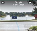
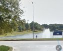
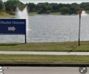
Here is some additional screenshots of the updated Google maps 2021 street view
Reflection Bay toward the Retention Pond.
Hope this helps on a better visual if not posted before .
 

Attachments

  • Screenshot_20210520-151618_Maps.jpg
    Screenshot_20210520-151618_Maps.jpg
    82.3 KB · Views: 69
  • Screenshot_20210520-151710_Maps.jpg
    Screenshot_20210520-151710_Maps.jpg
    88 KB · Views: 83
  • Screenshot_20210520-151823_Maps.jpg
    Screenshot_20210520-151823_Maps.jpg
    97.2 KB · Views: 66
But absolutely no tyre tracks, no marks on the grass, no mud, no curb damage.....nothing. That's the bit that doesn't make sense. If she was travelling that fast, there'd be something the neighbours would notice....
 
But absolutely no tyre tracks, no marks on the grass, no mud, no curb damage.....nothing. That's the bit that doesn't make sense. If she was travelling that fast, there'd be something the neighbours would notice....

I’m not saying none of the above is or isn’t true.
But do we know for sure that there wasn’t any evidence of tire tracks, mud, or curb damage? Also, would tire tracks, etc be as noticeable after 3 weeks?
I genuinely don’t know; that’s why I’m asking.
 
I’m not saying none of the above is or isn’t true.
But do we know for sure that there wasn’t any evidence of tire tracks, mud, or curb damage? Also, would tire tracks, etc be as noticeable after 3 weeks?
I genuinely don’t know; that’s why I’m asking.
Plus they weren’t expecting her to be in that area? It’s not like it’s on her way home from her friends house?
 
Here is some additional screenshots of the updated Google maps 2021 street view
Reflection Bay toward the Retention Pond.
Hope this helps on a better visual if not posted before .
How do you get yours to show current view? When I used my computer at work it says 2021 in the lower right corner for overhead shot but when I go to street view it says 2016 in the lower right corner. I tried zooming in from above to look at the sign with 2021 but not enough detail. We need someone to drive by but I’m on opposite side of town. I know there were some videos floating around on social media of people driving that road. I’ll have to see if I can find them.

ETA: the news story’s on Social Media have some decent shots of the lake. It’s much steeper than I expected. Not sure if they are reporter’s pages if I can link them or not.
 
Last edited:
I seriously would like to encourage those following this case to please go on to the Google maps street view as if you are driving on Reflection Bay toward the Retention Pond. There are 2 lanes traveling toward the pond and 2 lanes traveling north up from the pond.
#1 Had the SUV been traveling in the left lane toward the pond thru the stop sign it would have hit head on with the steel dusk to dawn light pole.
#2 Had the SUV been traveling in the right lane toward the pond thru the stop sign it would have hit head on a large sturdy 5-6ft wooden "new homes" signage along with a 4- 5ft orange utility pipe that is just a few feet to the right side of the sign.
#3 There is zero front end damage to the 2020 GMC Acadia as shown on multiple news media feeds from the time it was being removed from the 8-15ft deep Retention Pond per Pearland PD.

IMO This would not be the actual point of entry for the SUV given the objects and structures hindering the vehicle and zero front end damage. I can not see how a driver alert or not can miss all 3 objects as well as zero damage to the Front End of the SUV. MOO
Screenshot for Reference

WOW!
The factors/obstacles described above add even MORE to the mystery of just how/when/where and why poor Erica was found in the Acadia submerged in that body of water!
 
I’m not saying none of the above is or isn’t true.
But do we know for sure that there wasn’t any evidence of tire tracks, mud, or curb damage? Also, would tire tracks, etc be as noticeable after 3 weeks?
I genuinely don’t know; that’s why I’m asking.
Well, if there were tyre tracks or skid marks heading in towards the lake, I'm sure it would have aroused suspicion the next day or day after that with the people who live in that area, go jogging, walk past, take dogs out, or even live in those houses overlooking the lake.
 
How do you get yours to show current view? When I used my computer at work it says 2021 in the lower right corner for overhead shot but when I go to street view it says 2016 in the lower right corner. I tried zooming in from above to look at the sign with 2021 but not enough detail. We need someone to drive by but I’m on opposite side of town. I know there were some videos floating around on social media of people driving that road. I’ll have to see if I can find them.

ETA: the news story’s on Social Media have some decent shots of the lake. It’s much steeper than I expected. Not sure if they are reporter’s pages if I can link them or not.
hmm I just did it thru Google maps.
I also have a contact that lives in the houses 1 street behind the Retention Pond. Yes it is much steeper than it may look down to the water edge. She is an avid walker every other day or so on that wide sidewalk in front of the pond. My contact was also a 1st hand observer on the discovery and the removal of the SUV.
 
WOW!
The factors/obstacles described above add even MORE to the mystery of just how/when/where and why poor Erica was found in the Acadia submerged in that body of water!
Absolutely correct.
Even more astonishing is the 2020 GMC Acadia features and technology. The onstar has many capabilities since it was upgraded in the 2020 GMC SUVs .
Hope this helps .
 

Members online

Online statistics

Members online
145
Guests online
2,646
Total visitors
2,791

Forum statistics

Threads
602,694
Messages
18,145,406
Members
231,495
Latest member
permanentvacation
Back
Top