re. the difference between wind direction at SEATAC per the weather service and the direction (180, magnetic) someone identified as "ground control" stated to 305 just before takeoff:
According to weather service (METAR) data at WeatherUnderground (historical) the 7pm wind at SEATAC was from 170°true (170°t). According to an aviation weather report printed the night of the hijacking, the 8pm wind at SEATAC was from 160°t. So the wind at takeoff time could easily have been anywhere between 160°t and 170°t, although it would most likely be about 165°t. The weather service reports are rounded to the nearest 10 degrees. That is, the rounding error is ±5 degrees.
The magnetic declination at SEATAC on hijack night was 20.9454°. We'll call it 21°. This means the weather service wind directions for 7pm and 8pm would mean 149° (magnetic) and 139°m(ag), respectively. But the ±5 degrees apply here as well, so the range would be 134°m to 154°m. It would be well outside the range of what could be called 180°m.
I think it is by far most probable that the weather service data is closer to correct than the statement "GC" made to 305 just before takeoff. The weather service data is two different observations, half an hour either side of takeoff time. The 8pm number is from an aviation weather report printed out that very night. It is barely possible that the direction might have been from 180° magnetic (180m) for a short time, but it is not likely that it would be so different from a prevailing direction of 140m to 150m for long.
I think it is likely that whoever made the statement over the radio made a simple mistake. If he got the direction from the weather service it would have been "true" rather than magnetic. To report to 305 in magnetic as flight controllers do, he would have needed to subtract 20° from the "true." There's a good chance he just added the 20 rather than subtracting it.
IMPACT OF FLYING BASED ON INCORRECT WIND INFO
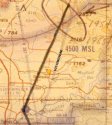
If 305 thought the winds were going to be from 180°m, which would be 201°t, this would be almost a pure headwind coming from just 5° off the nose (from a bit west). They would be expecting to be blown a tiny bit eastward. (V23 airway ran 175°m out from SEATAC in 1971, and runs 178°m now.)
If they expected that they would be flying mostly at 10,000 feet on the way to the Mayfield (now Malay) intersection near Toledo, they would have expected the wind speed to be about 30 to 35 knots (kt). A 35kt wind from 201°t would have blown them barely over 1° off course toward the east. They could compensate by heading the nose 1° to the west of the direction they wanted to go.
If they realized that they would be loitering a while at 7000' while enroute to the intersection, they would expect the average windspeed to be about 25kt, which would have blown them about .74° off course (toward the east). If they wanted to compensate for this so as to stay on the V23 centerline, they could have headed that much to the west of V23. But the smallest heading division on the CDI is 5°. If they wanted to compensate, the best they could do would be to estimate about what 1° would be. They would head toward 176m (197t) rather than 175m. It's likely they would not even try to compensate for such a small wind effect, but let's assume for now that they did.
If the average wind of 25kt was actually from 140°m rather than 180°m, it would be less of a headwind and would push the flight westward (in addition to the 1° westward correction of the heading) rather than eastward. The wind would push the flight about 14.7kt toward 287°t (WNW, perpendicular to the 197°t heading) giving a course of about 5.0° to the west of the heading (205°t or 184°m). This plus the 1° heading correction to account for the wind they mistakenly expected would be about 6° clockwise of V23 centerline. I've measured the flightpath as being about 6° clockwise from V23 centerline, so this matches the plot well.
The average groundspeed to the 19:58 point is 168.81kt based on the "FBI" flightpath plot and a takeoff at 7:36:33 (which seems to be working well). Based on this and the calcs in the preceding paragraph, the average true airspeed (TAS) from takeoff to the 19:58 point would be 188.4kt. Based on the average elevation being 7000', this would be about 169.6KIAS average speed from takeoff to the 19:58 point.
I think it is most probable that the 305 crew intended to fly right down the centerline of V23. They were not accustomed to VOR (victor) airway flying. If they were comfortable with using their VORs they could have done that and just kept the heading where the CDI told them to go. This would have kept them much closer to the V23 centerline than what they did. Or, they could have seen that V23 was a 175°m course out of SEATAC, made a correction for wind, and just headed the nose at 176°m.
The possibility that 305 flew on the basis of an incorrect wind report completely and very closely explains the direction and extent of departure from the V23 centerline as shown on the "FBI" flightpath plot.


now THAT is pain!! :lol: