2024 Hurricane and Tropical Weather

  • #341
FEMA has stationed SAR teams in numerous states with the current warnings - for the areas that have the flood and rainfall risks in the Appalachia and North/South Carolina areas, as well as the tornado risk areas of Georgia and Florida.
 
  • #342
1727378415239.png

 
  • #343
My word. You left FL to get outta this nonsense and crazy it followed you!!! Are you able to evacuate or are you up high enough?
Yes. Thank you
 
  • #344
“They” say we will be affected from 3pm-12am. It isn’t quite 3:00 yet and so far no wind and a steady drizzle. Just west of Dothan, AL.
 
  • #345
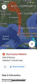
View the Hurricane Helene on Google Maps

Updated 7 minutes ago.
 

Attachments

  • IMG_6910.png
    IMG_6910.png
    536.2 KB · Views: 8
  • #346
..HELENE ACCELERATING TOWARD THE FLORIDA BIG BEND... ...TROPICAL STORM CONDITIONS OCCURRING ACROSS MOST OF THE WEST COAST OF FLORIDA...

4:00 PM EDT Thu Sep 26
Location: 27.3°N 84.7°W
Moving: NNE at 21 mph
Min pressure: 951 mb
Max sustained: 120 mph
 
  • #347

Attachments

  • 1727381200599.png
    1727381200599.png
    534.6 KB · Views: 10
  • #348
..HELENE ACCELERATING TOWARD THE FLORIDA BIG BEND... ...TROPICAL STORM CONDITIONS OCCURRING ACROSS MOST OF THE WEST COAST OF FLORIDA...

4:00 PM EDT Thu Sep 26
Location: 27.3°N 84.7°W
Moving: NNE at 21 mph
Min pressure: 951 mb
Max sustained: 120 mph

The barometric pressure has increased. That's a good sign. Better than the reverse.
 
  • #349
NOAA update at 4PM EDT:


000
WTNT64 KNHC 261955
TCUAT4

Hurricane Helene Tropical Cyclone Update
NWS National Hurricane Center Miami FL AL092024

400 PM EDT Thu Sep 26 2024

...HELENE ACCELERATING TOWARD THE FLORIDA BIG BEND...
...TROPICAL STORM CONDITIONS OCCURRING ACROSS MOST OF THE WEST
COAST OF FLORIDA...

Data from an Air Force Hurricane Hunter aircraft indicate that the minimum pressure of Helene has decreased to 951 mb (28.08 inches).
A Weatherflow station at Egmont Channel at the entrance to Tampa Bay recently measured a sustained wind of 54 mph (87 km/h) and a gust to 68 mph (109 km/h).
The Sarasota-Bradenton International Airport recently measured a sustained wind of 43 mph (69 km/h) and a gust to 63 mph (101 km/h).

SUMMARY OF 400 PM EDT...2000 UTC...INFORMATION

----------------------------------------------

LOCATION...27.3N 84.7W
ABOUT 145 MI...235 KM WSW OF TAMPA FLORIDA
ABOUT 165 MI...265 KM S OF APALACHICOLA FLORIDA
MAXIMUM SUSTAINED WINDS...120 MPH...195 KM/H
PRESENT MOVEMENT...NNE OR 25 DEGREES AT 21 MPH...33 KM/H
MINIMUM CENTRAL PRESSURE...951 MB...28.08 INCHES

$$

Forecaster D. Zelinsky


Hurricane Helene Update Statement
 
Last edited:
  • #350
...HELENE IS A VERY DANGEROUS AND LARGE MAJOR HURRICANE... ...DAMAGING HURRICANE WINDS AND CATASTROPHIC STORM SURGE EXPECTED TO BEGIN IN THE FLORIDA BIG BEND THIS EVENING...

5:00 PM EDT Thu Sep 26
Location: 27.9°N 84.6°W
Moving: NNE at 23 mph
Min pressure: 951 mb
Max sustained: 125 mph
 
  • #351
...HELENE CONTINUES HEADING FOR THE FLORIDA BIG BEND... ...TROPICAL STORM CONDITIONS SPREADING NORTHWARD ALONG THE WEST COAST OF FLORIDA...

6:00 PM EDT Thu Sep 26
Location: 28.0°N 84.5°W
Moving: NNE at 21 mph
Min pressure: 950 mb
Max sustained: 120 mph
 
  • #352
...HELENE CONTINUES HEADING FOR THE FLORIDA BIG BEND... ...TROPICAL STORM CONDITIONS SPREADING NORTHWARD ALONG THE WEST COAST OF FLORIDA...

6:00 PM EDT Thu Sep 26
Location: 28.0°N 84.5°W
Moving: NNE at 21 mph
Min pressure: 950 mb
Max sustained: 120 mph
NHC just corrected the wind speed. It should read 125 mph, not 120. And she's moving at 23 mph
 
  • #353
NHC just corrected the wind speed. It should read 125 mph, not 120. And she's moving at 23 mph
It’s going to roar onshore in the dark. Scares everyone and those who think they can shelter in place, may die. They can’t see the water coming.

I saw somewhere that they’re telling those who refused to evacuate, to write their name, address & phone number on their arm in Sharpie.

I remember years ago when they started telling people that, some couldn’t grasp why. I believe it was an officer who dead panned “So we can identify your body.” Boy, people comprehended quickly after hearing that.

JMO
 
  • #354
...HELENE NOW AN EXTREMELY DANGEROUS CATEGORY 4 HURRICANE...

6:20 PM EDT Thu Sep 26
Location: 28.0°N 84.5°W
Moving: NNE at 23 mph
Min pressure: 947 mb
Max sustained: 130 mph
 
  • #355
  • #356
It’s going to roar onshore in the dark. Scares everyone and those who think they can shelter in place, may die. They can’t see the water coming.

I saw somewhere that they’re telling those who refused to evacuate, to write their name, address & phone number on their arm in Sharpie.

I remember years ago when they started telling people that, some couldn’t grasp why. I believe it was an officer who dead panned “So we can identify your body.” Boy, people comprehended quickly after hearing that.

JMO

An NBC correspondent just reported that—
Jesse Kirsch

@JesseKirschNews


“Write your name and birthday on your body in permanent marker. That way your body can be ID’d. That’s what the Taylor County, Florida, sheriff wants people to do if they haven’t evacuated. This is a life-threatening, no joke storm. Latest
@NBCNews

@MSNBC
#HurricaneHelene
 
  • #357
DBM - She's now a cat 3, my heart is breaking for what is to come...
 
  • #358
DBM - She's now a cat 3, my heart is breaking for what is to come...
My family lives in Georgetown & Horry Counties. Pretty scary to be there too.
 
  • #359
...EXTREMELY DANGEROUS CATEGORY 4 HELENE HEADING TOWARDS THE FLORIDA BIG BEND... ...700 PM EDT POSITION UPDATE...

7:00 PM EDT Thu Sep 26
Location: 28.3°N 84.4°W
Moving: NNE at 23 mph
Min pressure: 945 mb
Max sustained: 130 mph
 
  • #360
Helene's eye is becoming clear. She's just hours away from landfall and still intensifying.

Screenshot 2024-09-26 at 16-06-24 GOES-East - Sector view Gulf of Mexico - GeoColor - NOAA _ N...png
 

Members online

Online statistics

Members online
64
Guests online
2,801
Total visitors
2,865

Forum statistics

Threads
633,220
Messages
18,638,118
Members
243,451
Latest member
theoiledone
Back
Top