From Rob’s video:This story wasn't going to have a happy ending, but it's some solace her loved ones are looking to get closure.
From the interview Jarrod gave:
Searcher recounts moment he found human remains at Philosopher Falls - ABC listen
And ABC clarified in their news article:
Is the mystery of missing tourist Celine Cremer at an end?
Playing around on satellites pro, that would place the discovery around here:
View attachment 640336


You are using an out of date browser. It may not display this or other websites correctly.
You should upgrade or use an alternative browser.
You should upgrade or use an alternative browser.
Australia Australia - Celine Cremer, 31, Belgium backpacker, car found at the Philosopher’s fall track, Waratah, Tasmania, 12 June 2023
- Thread starter StillDiggin
- Start date
- Joined
- Jan 23, 2021
- Messages
- 17,875
- Reaction score
- 110,084
The lower jawbone being found with teeth is so incredibly fortuitous and helpful. Dental features hold far more identifying detail than clean bone fragments, and this should make the identification process much more straightforward and reliable.
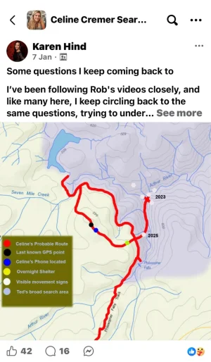
It has been said that Celine would have 'followed the Arthur river downstream (Eastbound), trying to reach the road'.From Rob’s video:
I don´t understand that, because the road towards the East is ki-lo-me-ters away.
Why wouldn't Celine have followed the river upstream instead? She already knew that her car was parked upstream, not downstream.
Another detail that I do NOT understand: the phone pings have shown a ping location at Waratah's golf course the day after the last ping near Magnet dam. According to the narrative, the pings at Waratah town, were caused by the presence of the masts in town. OK, so why were those golf course pings not gps-located at the mast? Why were they gps-located at the golf course? I don't get it.
If that is Celine, it’s weird that she went north east, especially if she was using a compass, as the carpark is south. Feels like a long walk in tough conditions and in the wrong direction. Possibly frozen, disoriented & just following the river. Wonder why Jarrod even headed that way and so far away from Rob’s search areas and where the phone was found.
Who knows the mindset of a fatigued person, but fr
Bones were found in area that was probable underwater in winter, the guy who found them seemed to indicate that were washed down stream. Maybe she stopped at the spot where the bottle and , then missed the water race, and proceeded down to the river, then went back towards the falls. But the bush was very steep and thick there. She than falls, breaks who knows what, or just falls into the freezing river exacerbating her hyperthermia.It has been said that Celine would have 'followed the Arthur river downstream (Eastbound), trying to reach the road'.
I don´t understand that, because the road towards the East is ki-lo-me-ters away.
Why wouldn't Celine have followed the river upstream instead? She already knew that her car was parked upstream, not downstream.
Another detail that I do NOT understand: the phone pings have shown a ping location at Waratah's golf course the day after the last ping near Magnet dam. According to the narrative, the pings at Waratah town, were caused by the presence of the masts in town. OK, so why were those golf course pings not gps-located at the mast? Why were they gps-located at the golf course? I don't get it.
Of course we still don't know it is her, but I think the chances are high.
Here´s a map where the remains have been found (approximately). It's quite far away from the water race:

 www.abc.net.au
"That location is consistent with our theory that potentially she could have been trying to reach the road and may have done so by moving towards the river, knowing that following it downstream may eventually lead to that road,"
www.abc.net.au
"That location is consistent with our theory that potentially she could have been trying to reach the road and may have done so by moving towards the river, knowing that following it downstream may eventually lead to that road,"
[Whereas Philosopher's Falls are upstream and whereas Celine's car was also parked upstream.]
Low water levels to aid police river search for Celine Cremer remains
Tasmania Police says six experts have been flown in via helicopter to conduct a line search of the Arthur River, where human remains were found this week.
www.abc.net.au
[Whereas Philosopher's Falls are upstream and whereas Celine's car was also parked upstream.]
- Joined
- May 24, 2012
- Messages
- 16,659
- Reaction score
- 117,676
Daily Mail
More grim discoveries made in the search for missing Belgian backpacker Celine Cremer
Items of clothing believed to belong to a Belgian tourist who disappeared more than two years ago have been discovered near more human remains.
Commander Nathan Johnston confirmed officers also found a polar fleece jacket, believed to belong to Ms Cremer, on Friday.
He said a bra and a thermal top had also been discovered, along with more bones.
'Whilst further forensic examination will need to be conducted to confirm the identity, due to the nature of the items located, and the location, we believe they are Celine's,' Mr Johnston told reporters.
- Joined
- May 24, 2012
- Messages
- 16,659
- Reaction score
- 117,676
Private searches take over when police resources run dry
Facing extreme weather and limited resources, Tasmania Police had to stop its search for Celine Cremer. But with her disappearance unresolved, loved ones turned to a private investigator instead.
www.abc.net.au
ABC News Australia
Celine Cremer case shows role of private investigators in helping families find answers
This sounding like she was way better prepared than I thought.
Thermal top, fleece jacket, then add garbage bag over the top for waterproofing your top, separate small bag that could have covered her head, along water bottle and probably backpack, and compass. Whilst it was cold, it makes me think that she got injured then hyperthermia impacted.
Thermal top, fleece jacket, then add garbage bag over the top for waterproofing your top, separate small bag that could have covered her head, along water bottle and probably backpack, and compass. Whilst it was cold, it makes me think that she got injured then hyperthermia impacted.
Images at the Arthur river. It's very shallow:


Source: Celine Cremer search paused after human remains and clothing found
Source: Celine Cremer search paused after human remains and clothing found
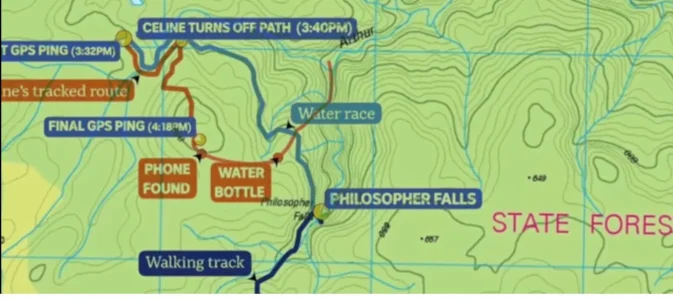
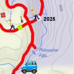
It appears that the final, fateful mistake came after Celine left the shelter with the bag and bottle. Without her phone to orient herself, she tried to head back toward the carpark and came close, but fatally missed the turnoff. Instead she went straight ahead, crossed the water race and continued on towards the Arthur River. I think that if she’d made that pivotal right‑hand turn back toward the falls and carpark, she would’ve made it out. I remember Rob mentioning Celine crossing the water race but didn't understand its significance until I saw the image below.
Attachments
- Joined
- May 24, 2012
- Messages
- 16,659
- Reaction score
- 117,676
ABC News Australia
Tasmania Police search for Celine Cremer 'paused', as wait on DNA results from human remains continues
Following a second day of searching in harsh terrain, Tasmania Police say efforts to find more items linked to missing backpacker Celine Cremer have been "paused".
Officers were dropped by helicopter along a section of the Arthur River, in the state's north-west, for a second day, following the discovery of further human remains and several items of clothing on Friday.
On Saturday, police said the team of six search and rescue experts had "focused on an area downstream from where the items of interest were located on Friday".
"While it is unfortunate we have not located any further items today, our crews have searched extensively over the past two days, and the discoveries made yesterday remain significant," Commander Johnston said.
"At this stage, the search will not resume tomorrow [Sunday], with a plan to reassess the situation.
"As we have previously stated, we understand the strong public interest in this case, and will continue to provide information to the community when we are able to do so."
It appears that the final, fateful mistake came after Celine left the shelter with the bag and bottle. Without her phone to orient herself, she tried to head back toward the carpark and came close, but fatally missed the turnoff. Instead she went straight ahead, crossed the water race and continued on towards the Arthur River. I think that if she’d made that pivotal right‑hand turn back toward the falls and carpark, she would’ve made it out. I remember Rob mentioning Celine crossing the water race but didn't understand its significance until I saw the image below.
Yes, I think Rob also said in the video where he was talking to Jarrod, that the path down the water race has been cleared now so it's more obvious than it probably was back then.
Likewise where the first mistake Celine made to turn off the main path because she probably thought she was heading away from the car park (which she was but the path turned back to the right later) - think they've put a sign there now as well.
The loss of the phone was the key though, I reckon she'd have made it out if she'd had her phone.
ABC News Australia
Tasmania Police search for Celine Cremer 'paused', as wait on DNA results from human remains continues
Following a second day of searching in harsh terrain, Tasmania Police say efforts to find more items linked to missing backpacker Celine Cremer have been "paused".
Officers were dropped by helicopter along a section of the Arthur River, in the state's north-west, for a second day, following the discovery of further human remains and several items of clothing on Friday.
On Saturday, police said the team of six search and rescue experts had "focused on an area downstream from where the items of interest were located on Friday".
"While it is unfortunate we have not located any further items today, our crews have searched extensively over the past two days, and the discoveries made yesterday remain significant," Commander Johnston said.
"At this stage, the search will not resume tomorrow [Sunday], with a plan to reassess the situation.
"As we have previously stated, we understand the strong public interest in this case, and will continue to provide information to the community when we are able to do so."
I guess after two and a half years it's fortunate that the remains have not been washed out to sea, though there do appear to be a lot of obstructions from fallen trees etc. I imagine they'll want to search upstream as well, given the amount of time it's been.
- Joined
- May 24, 2012
- Messages
- 16,659
- Reaction score
- 117,676

Chilling new theory over how Belgian backpacker Celine Cremer died
Celine Cremer was 31 when she vanished from the Philosopher Falls hiking trail near Waratah, 300km northwest of Hobart, in June 2023.
Daily Mail
Bones found 'scattered' along river: Chilling new theory about how Belgian backpacker Celine Cremer died in Tasmania
There is speculation that she may have tried to cross the Arthur River using downed trees, but possibly slipped and drowned, with her body becoming trapped among the debris.
Ken Gamble also told the Daily Mail:Daily Mail
'At this stage, it is far too early to draw any definitive conclusions about what happened to Celine. What can be said is that the discovery of scattered remains in and around sections of the Arthur River suggests a possibility that she may have entered the water at some point,' he said.
'This is a recognised natural process in river environments, but it should not be interpreted as a conclusion about what occurred in Celine's case.'
Police will resume searches coming Sunday
 www.abc.net.au
Police to resume searching for Celine Cremer items in wilderness
Tasmania Police will again head into thick bushland to continue searching for more items in the area where Belgian tourist Celine Cremer vanished in 2023 — after the shock discovery of bones last week.
www.abc.net.au
- Joined
- May 24, 2012
- Messages
- 16,659
- Reaction score
- 117,676
Car key, more bones found in search for Celine Cremer
Tasmania Police have located further items believed to be linked to missing Belgian tourist Celine Cremer, including more bones and a car key.
www.abc.net.au
Car key, teeth found by Tasmania Police searching for missing tourist Celine Cremer
Tasmania Police have located further items believed to be linked to missing Belgian tourist Celine Cremer.
Commander Nathan Johnston said the specialist search team "completed a detailed examination of a 350-metre section of the Arthur River on Sunday and Monday".
Searchers found "five additional bones, two teeth and a Honda car key," Commander Johnston said in a statement.
"Police have today formally verified that the car key belongs to Celine," he said.
"The search undertaken over the past two days was thorough and methodical, and many of these items were located beneath debris, embedded in the riverbed itself."
Why she would have done this, we'll never know, but crossing the river would also explain why Ted Mead found footprints on both the North and Eastern banks of the Arthur River. Maybe the river is not as brutal down stream in winter as suggested.Chilling new theory over how Belgian backpacker Celine Cremer died
Celine Cremer was 31 when she vanished from the Philosopher Falls hiking trail near Waratah, 300km northwest of Hobart, in June 2023.www.dailymail.co.uk
Daily Mail
Bones found 'scattered' along river: Chilling new theory about how Belgian backpacker Celine Cremer died in Tasmania
There is speculation that she may have tried to cross the Arthur River using downed trees, but possibly slipped and drowned, with her body becoming trapped among the debris.
Given that all the remains have been found relatively close together, perhaps she never had a backpack with her. I don't think it's ever been confirmed, aside from her mum telling the friend about a possible compass on the strap of the backpack in Rob's video. Céline intended to go on a short walk, so it would make sense not to bring a backpack. It would mean she carried the glass water bottle some other way however, which in turn might explain why she left it, as it became a burden.
Car key, more bones found in search for Celine Cremer
Tasmania Police have located further items believed to be linked to missing Belgian tourist Celine Cremer, including more bones and a car key.
Car key, teeth found by Tasmania Police searching for missing tourist Celine Cremer
Tasmania Police have located further items believed to be linked to missing Belgian tourist Celine Cremer.
Commander Nathan Johnston said the specialist search team "completed a detailed examination of a 350-metre section of the Arthur River on Sunday and Monday".
Searchers found "five additional bones, two teeth and a Honda car key," Commander Johnston said in a statement.
"Police have today formally verified that the car key belongs to Celine," he said.
"The search undertaken over the past two days was thorough and methodical, and many of these items were located beneath debris, embedded in the riverbed itself."
It has been said that Celine would have 'followed the Arthur river downstream (Eastbound), trying to reach the road'.
I don´t understand that, because the road towards the East is ki-lo-me-ters away.
Why wouldn't Celine have followed the river upstream instead? She already knew that her car was parked upstream, not downstream.
Another detail that I do NOT understand: the phone pings have shown a ping location at Waratah's golf course the day after the last ping near Magnet dam. According to the narrative, the pings at Waratah town, were caused by the presence of the masts in town. OK, so why were those golf course pings not gps-located at the mast? Why were they gps-located at the golf course? I don't get it.
The Butler Road theory doesn't make any sense to me either. It seems so apparant to follow the river upstream, as all the landmarks on the map she was intently studying on her phone just hours earlier are in that direction. I like Rob's theory however, that she used the river only as a guide to locate the water race, since she knew it to run parallel to the river, and that was the landmark she was focused on finding.
Guardians Monthly Goal

Goal Reached! We hit our target of 75 new Guardians!
New stretch goal: 100!
Our goal for the month is 75 new Guardians members to sign up. Have you been thinking about becoming a member?
Click here to find out how!
Online statistics
- Members online
- 94
- Guests online
- 4,726
- Total visitors
- 4,820
Totals may include hidden visitors.
Forum statistics
Community Rules
-
Be CivilTreat all members with respect. No personal attacks, harassment, or inflammatory language.
-
Victim FriendlyAlways show respect for victims and their families. No victim blaming or insensitive speculation.
-
Fact-based SourcingProvide credible sources for claims. Distinguish between verified facts and personal theories.
-
Social Media UseDo not post direct links to personal social media profiles of private individuals.
-
Copyright and PaywallsDo not copy full articles. Summarize and link to the original source instead.
-
Privacy and Personal InformationDo not post personal information such as addresses, phone numbers, or workplaces.
-
Registered Sex-OffendersDo not name or speculate about RSOs unless officially named in connection to a case.
-
Stay On TopicKeep discussions relevant to the case or topic at hand. Avoid off-topic tangents.
-
Accounts, Moderation, and DisputesOne account per person. Contact moderators privately for disputes or concerns.
-
Solicitation and FundraisingNo solicitation, fundraising, or promotion of personal ventures without approval.