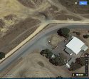
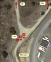
Yes I realise the image with the street signs of Stakehill and Baldivis is no where near the corner of the munitions centre shown in the 2017 images above.
But the overhead image, probably taken from the air is right on the intersection of the explosives facility. The same corner as above in the 2017 images. This is where the mystery pole is. The only sealed road is inside the perimeter fence of the ammunition centre. Stakehill is an unsealed road.
Corner of the Baldivis Ammunition facility with track leading to GR discovery.
Stakehill road is sealed. Always has been. I used to drive that way many years before.
The picture your showing above is at Baldivis Stskehill corner. There's now a roundabout there, because the government is moving the explosive facility and about to sell the land to developers. Back in 97 it was this sweeping bend because both Baldivis and Stakehill were 80kph roads. Before the freeway and the housing developments further north went in, Baldivis Rd, and Stakehill were a major shortcut to Mandurah Rd, especially if you came via Shepperton Rd, Albany Hwy, Nicholson Rd, King Rd and Mundijong Rd from the city,which was the usual route before the freeway was built.
The picture above is not the internal road inside the facility. As there are no power poles inside the facility (it has underground power) and the security fence that runs along the perimeter road is not in the picture.
The pole with a box, I've previously posted a street view of was removed when the roundabout went in and a transformer appears on a pole a bit further down in google Street View in 2015, which doesn't have a transformer on Google Street View in 2008. This is suggestive that the pole in the 1997 images was also a transformer. The poles shown in all these pics carry 3KiloVolt transmission wires. If street lights are required at the corner, or power for houses etc then a step down transformer is required to bring the voltage down to 240 volt. In those instances an extra set of 240V wires might appear below the 3KV line, or a cable running down the transformer to underground power might be visible. The 1997 images are not clear enough to ascertain, but the sheer size of the object on the pole is IMO too big to be a camera. I note in google Street View that there is an extremely large metal pole with what looks like a camera just south of the Gatehouse of the Explosives Depot, which probably has a complete View of the whole facility and main road in and out. The roadway in and the track are mostly parallel, but back in 1997 might of had pine trees between them. However, police did want to follow up reports of a white ute, and it might well be that a white use was glimpsed between trees from the gatehouse CCTV, confirming reports from other observers, eg Tennants at the facility, passing motorists, horse riders etc. Since 1997 all CCTV by Govt, Local Authorities, and many businesses had joined the blue iris project which allows police to quickly ascertain if an area of covered and contact tape holders, or in a lot of cases access live feeds where available. It's how they got the West Perth rapist.
Considering what Everett did there, I'm surprised by what I don't see in Google Earth images.
https://www.westpix.com.au/preview.asp?image=TWA-0064099&itemw=4&itemf=0001&itemstep=1&itemx=16 (incorrectly described as the crime scene)
https://www.westpix.com.au/preview.asp?image=TWA-0064096&itemw=4&itemf=0003&itemstep=1&itemx=72 (correctly described _ same location as the above)
Some articles about Blue Iris
https://thewest.com.au/news/wa/police-cctv-database-unusable-ng-ya-146050
http://www.perthnow.com.au/news/wes...w/news-story/d55f2ffe0f9c1c3b86f3a30508c97fd4
https://www.governmentnews.com.au/2015/04/cops-eye-massive-voluntary-cctv-expansion/
https://www.securityelectronicsandn...2/09/wa-plans-integrated-state-wide-cctv-2017
Sent from my HTC 2PQ910 using Tapatalk


