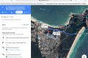
The path taken from Tennyson st has always bothered me. Why go that way to the Milne trail? I’ve done this before but if you drop a pin at the concrete slab and do a google map search to Tallows beach car park it’s 1.7km and would take 21 mins to walk( the shortest trip is past the yak, onto Gilmore, out onto Lawson and down Tallows beach road). Theo’s phone signal leaves the slab at 11:21pm. He/phone signal eventually make it out onto the beach next to abandoned camp at 11:48, that’s 27 mins of travelling and still not at Tallows beach car park. If he went the suggested google maps way he/phone would be at the car park roughly 11:42pm.
Also as mentioned in the podcast if you google map from CM the path takes you to Milne track. It does this as well from the end of Tennyson however I’ve found that it only takes you the Milne track when you search for Tallows beach. I think that’s because Tallows beach gps location marker is a little south. If you search for CC or lighthouse it takes you Lawson/tallows beach Rd but if you specifically search for Tallows beach it takes you Milne track.
From Tennyson going to Milne track actually backtracks you a little, making it a longer trip than going the Lawson/tallow beach Rd route.
Can someone explain to me what the purpose of going the Milne track/fire trail is?
It a longer, much more hazardous journey to take, even for a local. What is the point to go this way?
One thing that sticks out to me straight away is the isolation and the darkness. Once you make it to Milne, your totally off the grid and away from any witnesses.
IMO you only take a longer, more hazardous trip somewhere if you wanna stay outta sight.
Surely a local would know that route isn’t the shortest way to CC. What’s the motivation for taking that route?
Google maps walking pace is calculated around 4.5km/h IIRC. That’s the speed Theo/his phone went up the hill past massinger, he walked from Tennyson to massinger at 6km/h and walked the sandy trail at 7.5km/h. If he travelled at those speeds going the Lawson/tallows beach Rd route he most likely would have made it there in less than 21 mins IMO.
So seriously, why take the Milne track route? Cos it wasn’t to save time
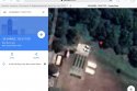
Also just to add, when I google maps from safari and not the app, you can see at least one car parked on the concrete slab. If you street view it you can see how easily you could get s vehicle on the slab. I wonder if there was a car/s parked there that night.
Also, I wonder if no.26 Tennyson heard or witnessed anything?
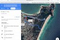
Also as mentioned in the podcast if you google map from CM the path takes you to Milne track. It does this as well from the end of Tennyson however I’ve found that it only takes you the Milne track when you search for Tallows beach. I think that’s because Tallows beach gps location marker is a little south. If you search for CC or lighthouse it takes you Lawson/tallows beach Rd but if you specifically search for Tallows beach it takes you Milne track.
From Tennyson going to Milne track actually backtracks you a little, making it a longer trip than going the Lawson/tallow beach Rd route.
Can someone explain to me what the purpose of going the Milne track/fire trail is?
It a longer, much more hazardous journey to take, even for a local. What is the point to go this way?
One thing that sticks out to me straight away is the isolation and the darkness. Once you make it to Milne, your totally off the grid and away from any witnesses.
IMO you only take a longer, more hazardous trip somewhere if you wanna stay outta sight.
Surely a local would know that route isn’t the shortest way to CC. What’s the motivation for taking that route?
Google maps walking pace is calculated around 4.5km/h IIRC. That’s the speed Theo/his phone went up the hill past massinger, he walked from Tennyson to massinger at 6km/h and walked the sandy trail at 7.5km/h. If he travelled at those speeds going the Lawson/tallows beach Rd route he most likely would have made it there in less than 21 mins IMO.
So seriously, why take the Milne track route? Cos it wasn’t to save time
Also just to add, when I google maps from safari and not the app, you can see at least one car parked on the concrete slab. If you street view it you can see how easily you could get s vehicle on the slab. I wonder if there was a car/s parked there that night.
Also, I wonder if no.26 Tennyson heard or witnessed anything?