Looks like someone has been arrested
http://www.police.nsw.gov.au/news/n...vdi5hdSUyRm1lZGlhJTJGNjYzODYuaHRtbCZhbGw9MQ==
Anyone we know? Too late now to search todays Court List. No doubt his name will be suppressed.


Looks like someone has been arrested
http://www.police.nsw.gov.au/news/n...vdi5hdSUyRm1lZGlhJTJGNjYzODYuaHRtbCZhbGw9MQ==
thanks for that. glad they got this creep! I live pretty close to these areas. Iluka is on the other side of the river from Yamba, takes at least 20-30 minutes to get from one place to the other...
So glad they got him too - for everyone's sake. I was in Yamba in July (the first week of the school hol's) with my daughter who is of similar age. Was at that very shopping centre. Kind of hits home. What a sick creep...
Iailwa, thank you for reporting on Kendall, and please do post your photographs. This is most interesting and relevant and not "clogging" the thread!

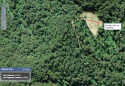
") but loose pixels and unable to see the roads leading out...
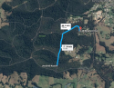
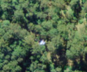
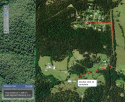
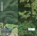
but loose pixels and unable to see the roads leading out... ") this is a close up cobb & co road (at the top of the screen) and the abandoned abattoir & house. where i start the line on the left is the abandoned abattoir with old machinery or something. i could definitely see a a lot of rust. or maybe it's an old cow milking shed? where the line finishes on the right is the abandoned house. not sure if it's one & the same property? easy to hide here for an hour or more before people have got this far. it's long abandoned. also private - being set a bit off cobb & co, and hidden behind a tree line. within-2km easy drive from william's house. or 1km as the crow flies..
this is a close up cobb & co road (at the top of the screen) and the abandoned abattoir & house. where i start the line on the left is the abandoned abattoir with old machinery or something. i could definitely see a a lot of rust. or maybe it's an old cow milking shed? where the line finishes on the right is the abandoned house. not sure if it's one & the same property? easy to hide here for an hour or more before people have got this far. it's long abandoned. also private - being set a bit off cobb & co, and hidden behind a tree line. within-2km easy drive from william's house. or 1km as the crow flies..ok another one, humour me

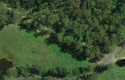
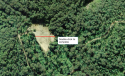
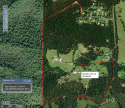
hey guys - until i find my phone - i just wanted to show you how easy & quick (altho it took me longer!) to get from the end of benaroon to that humpy place in the bush. I thought it was a dead end because it said private property - but now i don't think so, knowing which direction i took. Will show you close up from 6 maps too. Not suggesting these peeps did it at all. just showing how easy a 4wd can escape. From this house i notice two tracks that lead back to batar, that i noticed have a wire electric fence across them (looking from Batar creek road). No doubt for cattle but easily unlatched if you know how to. well used tracks too. anyone familiar could use these roads to get out onto batar creek rd.

Iailwa, would you please highlight the rest of this street if you have time, to demonstrate how you can get onto this property from Cobb and Co and from Batar Creek road, to show that it is all the same property? So from Benaroon dr, the cul de sac end through the state forest to the Batar Creek end and then Benaroon drive onto Batar Creek road entering at Cobb and co. TIA.
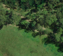
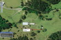
Close up pf the two tracks that merge with batar creek rd. the road at the bottom is the one that hooks up into kendall forest. They are both opposite foxes creek road, which you can see in the bottom right of the pic. If you look at google maps you can't see the lower road properly, just sightly (image from 2010), but you can see it here from 6 maps more clearly, which is more recent.