BBM.
You call them hills, I call them rocks, or more properly, rock formations.
")
Here are two screenshots from Google Earth, one showing the whole area with its various paths, and the other focused in on the larger rock formation on the south side of the creek bed, which I'm guessing was the goal of RT's and BT's walk.
That said, they look climbable, so maybe it doesn't matter what we call them. Still, I'm wondering whether RT would've referred to rock formation as a hill. Also,
@dbdb11's sister recalled that RT in a call to family said BT took the 360 photo that
morning, which doesn't fit with an early afternoon walk from Kelbaker/Hidden Hill. Again, the time-line is muddled. So maybe the 360 photo was taken from somewhere else??
On the other hand, if the 360 was taken from somewhere else, it's hard to see why RT thought the cars in the parking lot would be relevant to a possible abduction, unless he thought someone was following their truck or was clutching at straws. It's a conundrum.
CA - CA - Barbara Thomas, 69, Bullhead City, hiking wearing bikini in Mojave desert, 12 July 2019
The 360 photo aside, that's definitely the area where RT said BT disappeared; I agree with your other points. (I don't know whether the specialities of RT's attorney have been discussed in MSM.)
JMO
I'm calling them "hills" because they are known as the Granite Hills (for one reason) and because people here have been referring to them as hills since I came onto this thread. Of course they are rock formations. From a distance, to many people driving by, they do look like "hills" (although all hills have rocks inside of them).
Some of them are way more climbable than others. The highest part of the Granite Hills would not, I think, be accessible in a mere 1-2 hour hike. They are the darker rocks, too, and the temps there would have been higher. I wish we knew exactly where they went, but I'd bet good money they didn't go to the dark, taller part of that set of rocks - they went to the sandstone outcropping to the north (probably) or maybe even the one north of the creekbed (from which that northern square parking lot is visible). We see in the search photos that the dogs and SAR personnel are in the sandstone area.
To me, it's inconceivable that she would leave RT, and instead of heading toward the road, walk toward the really obvious opposite direction to the tallest point in the area (the granite). I don't think she walked back up those sandstone rock formations, either. That would have been so exerting and she was tired and hot. MOO.
It is so confusing. If she did head back toward any part of the Granite Hills/rocks, those were searched, but boy is that a weird thing to do. If she chose the wrong trail and headed south, she'd still hit the road. If she went north, she'd have run into RT again, and if she went the proper direction (east), she'd be at the RV within 5-7 minutes even at a slow pace.
It's easy to go to the grim proposition of "she was in the desert that day, and may have been atop those rock formations, but that's not where she went missing."
Or...she was in a very different state of mind than a calm woman, perfectly healthy, attempting to get to her RV for A/C and a brew.
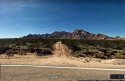
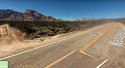
1. Granite Hills from the RV's POV (with the sandstone boulders to the right):
2. Granite Hills closer up, with better pictures of the sandstone boulders:
I've been inviting a few Mojave-based community groups to stop by this thread, so I keep posting the photos (ATV users, archers, rock collectors).