

You are using an out of date browser. It may not display this or other websites correctly.
You should upgrade or use an alternative browser.
You should upgrade or use an alternative browser.
Found Deceased CA - Fang Jin, 47, flew to LA from China, train to Palm Springs, Morongo Basin, 21 Jul 2023, w/ John Root Fitzpatrick, 55, (fnd dec.), 30 Jul ‘23 #3
- Thread starter imstilla.grandma
- Start date
- Joined
- Jun 30, 2010
- Messages
- 2,920
- Reaction score
- 13,353
Drones are prohibited in Anza-Borrego Desert State Park. Sorry, idk how to link on my phone but it's on the California State Park website.Who can provide recent detailed zoomable sattelite images , drone pictures of harper canyon , harper flat , pinyon wash ?
What would it cost to obtain ?
Drones are prohibited in Anza-Borrego Desert State Park. Sorry, idk how to link on my phone but it's on the California State Park website.

Drones are currently allowed in State Parks, State Beaches, State Historic Parks, State Recreational Areas, and State Vehicular Recreation Areas except where prohibited by a District Superintendent’s posted order. Posted orders may prohibit drones for numerous reasons, including: protection of threatened species; threats to cultural and natural resources; high fire danger; public safety; recreational conflicts; impacts upon visitor experience privacy; and park unit classification. Therefore, drone users should always check with their local State Park District for any specific posted orders.
Drones in State Wilderness Areas, Natural Preserves, and Cultural Preserves:
State Park regulations prohibit the use of motorized equipment (including UASs) within wilderness areas, cultural preserves, and natural preserves (Cal. Code Regs. tit. 14, § 4351.) Therefore, drone users should always check the designation of the park unit before operating a drone.

Last edited:
- Joined
- Jun 30, 2010
- Messages
- 2,920
- Reaction score
- 13,353
Drones are currently allowed in State Parks, State Beaches, State Historic Parks, State Recreational Areas, and State Vehicular Recreation Areas except where prohibited by a District Superintendent’s posted order. Posted orders may prohibit drones for numerous reasons, including: protection of threatened species; threats to cultural and natural resources; high fire danger; public safety; recreational conflicts; impacts upon visitor experience privacy; and park unit classification. Therefore, drone users should always check with their local State Park District for any specific posted orders.
Drones in State Wilderness Areas, Natural Preserves, and Cultural Preserves:
State Park regulations prohibit the use of motorized equipment (including UASs) within wilderness areas, cultural preserves, and natural preserves (Cal. Code Regs. tit. 14, § 4351.) Therefore, drone users should always check the designation of the park unit before operating a drone.
View attachment 456477
eta: bbm. The "District Superintendent’s posted order":
https://www.parks.ca.gov/pages/638/files/940-15-002 CDD Unmanned Aircraft.pdf
"No person shall launch, land, or operate a powered unmanned aircraft or Unmanned AerialSystem (UAS) within Anza-Borrego Desert State Park®..."
"The operation of powered unmanned aircraft,including drones, is prohibited in Anza-Borrego Desert State Park."
https://www.parks.ca.gov/pages/638/files/park magazine 2016_finalweb.pdf
And from the Anza-Borrego Desert State Park's official FB page:
"Remember that DRONES ARE NOT ALLOWED in the park."
https://www.facebook.com/profile/100075938105921/search/?q=drones
Last edited:
- Joined
- Sep 13, 2023
- Messages
- 139
- Reaction score
- 2,677
Ok in this case maybe we need to send a huge group of Chinese volunteers to this park to help searching the remains of Fang or prove of data that can explain why John and his car were found in that region..... Or we put it into media that authorities are blocking an International Search operation ???eta: bbm. The "District Superintendent’s posted order":
https://www.parks.ca.gov/pages/638/files/940-15-002 CDD Unmanned Aircraft.pdf
"No person shall launch, land, or operate a powered unmanned aircraft or Unmanned AerialSystem (UAS) within Anza-Borrego Desert State Park®..."
"The operation of powered unmanned aircraft,including drones, is prohibited in Anza-Borrego Desert State Park."
https://www.parks.ca.gov/pages/638/files/park magazine 2016_finalweb.pdf
And from the Anza-Borrego Desert State Park's official FB page:
"Remember that DRONES ARE NOT ALLOWED in the park."
https://www.facebook.com/profile/100075938105921/search/?q=drones
Great post! I added the point where the fence crosses the road to the case map, along with a screenshot of your post. I also noted another spot where it looks like the dirt road from Pinyon Wash is blocked by debris.@mark1969 Based on what has been posted here, IMO the truck was disabled somewhere in the purple area because there is a fence that blocks vehicle access to Harper Flat. The fence can be seen here on Google Maps. The foot route of escape is the yellow line toward Harper Canyon. Remains location is marked per reports (5 miles from the truck as the crow flies). The wash area away from Harper Canyon Trailhead and toward Hwy 78 (as described here where the backpack was found) would be that large yellow wash area flowing away from Harper Canyon and the remains.
View attachment 456439
Below is the same map turned around showing the location of Hwy 78 better. The search area should be the yellow wash area IMO unless FJ stayed with the truck. But the discovery of her backpack (seemingly in the yellow wash area) would make that area a priority IMO.
View attachment 456440
All roads
borregohiking.com
Last edited:
That would be pretty dangerous for the volunteers. The terrain is pretty rough. It might be better to call in a professional search organization like Tim Miller and Texas EquuSearch Search And Recovery Non-ProfitOk in this case maybe we need to send a huge group of Chinese volunteers to this park to help searching the remains of Fang or prove of data that can explain why John and his car were found in that region..... Or we put it into media that authorities are blocking an International Search operation ???
- Joined
- Jan 26, 2023
- Messages
- 500
- Reaction score
- 2,001
For the truck to be found at Harper Flat it must have been driven up one of the mountain tracks. But I feel it must have been more hidden for at least part of the time, and that suggests it was somewhere off the track.
The body and belongings could have been swept quite a long way depending on the amount of flooding. This is an ABC10 video of Death Valley during Storm Hilary:
I'm not sure which is more or less likely: that the remains would be completely unmoved by the storm flooding, or that they would have travelled so far. I feel the location where JRF's remains were found has to be at least some distance from where he actually died.
The Park reported that literal tons of sand & soil was freshly deposited on the gravelly surface of washes, some of the trails were washed out and that the rains were so powerful some boulders were carried miles away.
- Joined
- May 5, 2009
- Messages
- 8,618
- Reaction score
- 61,125
Sorry, that says that storms like we had are capable of moving boulders miles away. That is how washes form.The Park reported that literal tons of sand & soil was freshly deposited on the gravelly surface of washes, some of the trails were washed out and that the rains were so powerful some boulders were carried miles away.
View attachment 456501
It does not say that this particular storm moved any boulders miles away.
Somewhat possible, not proven.
That would be pretty dangerous for the volunteers. The terrain is pretty rough. It might be better to call in a professional search organization like Tim Miller and Texas EquuSearch Search And Recovery Non-Profit
Here is the link to the page which has the Request for assistance form to fill in, must include the NamUS and LE file for Fang Jin's case.

Request Our Help - Texas EquuSearch Search And Recovery
This form is intended to be completed by family or those with personal knowledge of the missing person. Although we make every effort to assist families and
 texasequusearch.org
Ok in this case maybe we need to send a huge group of Chinese volunteers to this park to help searching the remains of Fang or prove of data that can explain why John and his car were found in that region..... Or we put it into media that authorities are blocking an International Search operation ???
I think media coverage would help put a focus on the case of Fang Jin missing, but I think this has to be at the national level at this point since the local and state media aren't staying on this news. It has to be such a helpless feeling for FJ's loved ones on the other side of the world. Thank goodness, though, that her friend and friend's husband are in the U.S. and able to help in any way they can. Media will need U.S. contact individuals and information.
Bogbacal2
Well-Known Member
- Joined
- Oct 11, 2021
- Messages
- 286
- Reaction score
- 2,564
Wouldn’t you think as close as JRF and his friend DH were, that DH would be actively involved in providing any answers to Mark (VI) or the family? Would certainly help. I’m sure DH knows if JRF would have attempted “off road” activities in his truck, what the plans were when they got to the area….JMO
- Joined
- Mar 23, 2010
- Messages
- 4,033
- Reaction score
- 30,179
Wouldn’t you think as close as JRF and his friend DH were, that DH would be actively involved in providing any answers to Mark (VI) or the family? Would certainly help. I’m sure DH knows if JRF would have attempted “off road” activities in his truck, what the plans were when they got to the area….JMO
Based on our VI’s posts, I get the feeling the family distrusts DH.
MOO
Bogbacal2
Well-Known Member
- Joined
- Oct 11, 2021
- Messages
- 286
- Reaction score
- 2,564
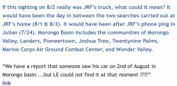
Timeline is starting to make sense to me..the maps provided tell a story and accident, washing away remains….EXCEPT-someone reports a sighting of the truck on 8/2 in Morengo Basin. If the sighting was 100% JRF, then accident theory is no longer my assumption. <mod edit: included link to referenced post>
Post in thread 'CA - Fang Jin, 47, flew to LA from China, train to Palm Springs, Morongo Basin, 21 Jul 2023, w/ John Root Fitzpatrick, 55, (fnd dec.), 30 Jul ‘23 #3'
CA - CA - Fang Jin, 47, flew to LA from China, train to Palm Springs, Morongo Basin, 21 Jul 2023, w/ John Root Fitzpatrick, 55, (fnd dec.), 30 Jul ‘23 #3
Attachments
Last edited by a moderator:
These guys hiked the area and also have downloadable KML tracks:

Harper Cabin and Dams Anza Borrego - I Hike San Diego
www.ihikesandiego.com
- Joined
- Jun 27, 2019
- Messages
- 15,985
- Reaction score
- 206,685
Yep, silly mistake. Meters.
It appears the Flat is far from "flat". At the south-western corner it's at 800m elevation and at the north-eastern corner where it leads into the canyon, it's dropping down to 700m. Anything washing down onto the "flat" would stand a high chance of heading down into the canyon--which is both where JRF's remains were found, and also in the vicinity of where our VI said JF's backpack may have been found closer to the road.
My suspicion is that the flood waters moved everything around.
")
I think that's the best theory right now. The map posted above showing the approximate location of the fence is very helpful. If the truck was up against the fence, it's possible it was moved by water as well.
The fact that items belong to path Fang and JRF were found nearby is very interesting. The fact that there were no camping supplies in the truck is interesting. Did they have a camp elsewhere? Were they free-camping in Anza-Borrego? If we start with them being at the western edge of Harper Flat (near the truck) then they must have traversed Harper Flat to get to the Canyon trailhead area.
I made a really rough estimate of how far it would be from the truck to the Canyon trailhead and it looks like about 3 miles. People used to camp right on Harper Flat (and still could, I believe, but the truck would be kept off the flat by the fence. It is possible that they established camp on the Flat itself (but all evidence of it was washed away). I feel this is not the strongest theory, since the Flat is in fact fairly flat, and the water coming down off of it would gather momentum as it went down the washes and canyons.
Still it's possible that the truck itself was pushed into the fence by water (but that would mean the truck was even further away from the top of the Canyon). Here's a view of the Flat taken from on the Flat:
There's no actual trail, but there are definitely traces of where trucks and cars have gone before. I'm just trying to imagine walking in heat across this area. And why anyone would decide to head for that particular canyon (Harper Canyon).
This next picture is apparently looking toward Harper Flat from the Pinyon Wash/Canyon where the fence was. Pinyon Wash is hikeable as well (and has some interesting rock formations) but JRF is found 3 miles or so away in Harper Canyon (at least that's what appears to be the case):
By now, I'm guessing that the canyon where JRF was found has been searched, I"m just trying to factor in the fence (in the past, it's been possible to drive onto Harper Flat and to camp there). Naturally, it's completely unimproved camping with no water. Was this a day trip gone wrong? I still can't fathom why there wasn't a big water canister in the truck.
IMO.
- Joined
- Jun 27, 2019
- Messages
- 15,985
- Reaction score
- 206,685
Timeline is starting to make sense to me..the maps provided tell a story and accident, washing away remains….EXCEPT-someone reports a sighting of the truck on 8/2 in Morengo Basin. If the sighting was 100% JRF, then accident theory is no longer my assumption.
I think someone simply saw a bright blue double cab Tacoma. I have been surprised at how many of them I saw on my daily commute during the time right after this pair when missing.
The way I read it, a blue truck was sighted, but I"m not sure the license plate was verified (I doubt most people would have the license plate memorized). I need way more than just a truck sighting in order to believe it was JRF's truck, as it makes no sense.
OTOH, I'm the one who has been suggesting that perhaps JRF did leave Morongo Valley, go down toward Julian, and then come back.
So...your theory is still on my list. If that sighting was indeed JRF, then the mobile home door being open at around the same time is very odd and concerning. It also would mean that the truck went to Pinyon Wash Road/edge of Harper Flat sometime after that. Since JRF's phone pinged near Julian on the 24th, he was in the general area prior - but perhaps not at Harper Flat. Odd that there are no more phone pings after the 24th. Did JRF acquire a new phone? Did he stop using his phone for some reason?
It's so hard to put all of this together.
IMO
- Joined
- Jun 27, 2019
- Messages
- 15,985
- Reaction score
- 206,685
The link I provided allows you to move around and find the elevations of the surrounding area.
Sunset Mountain and Whale Peak climb up to about 1300m on either side of the Flat, but the Flat itself is at around 700-800m. Just about everything else, including Harper Canyon and Pinyon Wash, heads DOWN from the Flat towards the road. Harper Canyon starts at about 300m elevation and ends at about 700m--that's a 1300ft elevation gain.
ETA: The Alltrails guide is talking about a steep 1300ft elevation gain from the road up to Harper Flat. When talking about the trip back down they simply say, "enter Harper Canyon and head back to car."
I finally got it - thank you for your patience. Is the road in question Pinyon Wash Road?
- Joined
- May 5, 2009
- Messages
- 8,618
- Reaction score
- 61,125
Is there no outcropping that would provide shade anywhere in the area?
If I’m going for the day, I would want to park with an overhang, if possible.
If I’m going for the day, I would want to park with an overhang, if possible.
Similar threads
- Locked
- Replies
- 977
- Views
- 112K
- Locked
- Replies
- 1,098
- Views
- 168K
Guardians Monthly Goal

Goal Reached! We hit our target of 75 new Guardians!
New stretch goal: 100!
Our goal for the month is 75 new Guardians members to sign up. Have you been thinking about becoming a member?
Click here to find out how!
Staff online
-
 CarlK90245UID Moderator
Online statistics
- Members online
- 226
- Guests online
- 3,490
- Total visitors
- 3,716
Totals may include hidden visitors.
Forum statistics
Community Rules
-
Be CivilTreat all members with respect. No personal attacks, harassment, or inflammatory language.
-
Victim FriendlyAlways show respect for victims and their families. No victim blaming or insensitive speculation.
-
Fact-based SourcingProvide credible sources for claims. Distinguish between verified facts and personal theories.
-
Social Media UseDo not post direct links to personal social media profiles of private individuals.
-
Copyright and PaywallsDo not copy full articles. Summarize and link to the original source instead.
-
Privacy and Personal InformationDo not post personal information such as addresses, phone numbers, or workplaces.
-
Registered Sex-OffendersDo not name or speculate about RSOs unless officially named in connection to a case.
-
Stay On TopicKeep discussions relevant to the case or topic at hand. Avoid off-topic tangents.
-
Accounts, Moderation, and DisputesOne account per person. Contact moderators privately for disputes or concerns.
-
Solicitation and FundraisingNo solicitation, fundraising, or promotion of personal ventures without approval.